Koshava Island
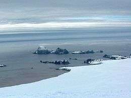 Zed Islands from Miziya Peak; Koshava Island is the rightmost one. | |
 Location of Varna Peninsula in the South Shetland Islands | |
 Koshava Island Location of Koshava Island  Koshava Island Koshava Island (Antarctica) | |
| Geography | |
|---|---|
| Location | Antarctica |
| Coordinates | 62°25′59″S 60°08′11″W / 62.43306°S 60.13639°WCoordinates: 62°25′59″S 60°08′11″W / 62.43306°S 60.13639°W |
| Archipelago | Zed Islands |
| Length | 0.34 km (0.211 mi) |
| Width | 0.22 km (0.137 mi) |
| Administration | |
| Administered under the Antarctic Treaty System | |
| Demographics | |
| Population | Uninhabited |
Koshava Island (Bulgarian: остров Кошава, ‘Ostrov Koshava’ \'os-trov ko-'sha-va\) is the easternmost island in the Zed group off Varna Peninsula, northeastern Livingston Island in the South Shetland Islands, Antarctica. The island is ice-free, extending 340 by 220 m (370 by 240 yd). Situated on the west side of the north entrance to McFarlane Strait, 140 m (150 yd) northeast of Lesidren Island, and 1.9 km (1.2 mi) north of Williams Point on Livingston Island. The area was visited by early 19th century sealers.
The island is named after the settlement of Koshava in northwestern Bulgaria.
Location
Koshava Island is located at 62°25′59″S 60°08′11″W / 62.43306°S 60.13639°W. Bulgarian mapping in 2009.
See also
Map
L.L. Ivanov. Antarctica: Livingston Island and Greenwich, Robert, Snow and Smith Islands. Scale 1:120000 topographic map. Troyan: Manfred Wörner Foundation, 2009. ISBN 978-954-92032-6-4
References
- Koshava Island. SCAR Composite Gazetteer of Antarctica.
- Bulgarian Antarctic Gazetteer. Antarctic Place-names Commission. (details in Bulgarian, basic data in English)
This article includes information from the Antarctic Place-names Commission of Bulgaria which is used with permission.

| General |
| .svg.png) |
|---|---|---|
| Geographic regions | ||
| Waterways | ||
| Famous explorers | ||