Chabrier Rock
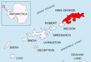
Location of King George Island in the South Shetland Islands.
Chabrier Rock (62°11′S 58°18′W / 62.183°S 58.300°WCoordinates: 62°11′S 58°18′W / 62.183°S 58.300°W) is a rock which lies 0.5 miles (0.8 km) southwest of Vauréal Peak in the east side of the entrance to Admiralty Bay, King George Island, in the South Shetland Islands. It was charted and named in December 1909 by the French Antarctic Expedition under Jean-Baptiste Charcot.
Maps
- Antarctic Digital Database (ADD). Scale 1:250000 topographic map of Antarctica. Scientific Committee on Antarctic Research (SCAR). Since 1993, regularly upgraded and updated.
References

| General |
| .svg.png) |
|---|---|---|
| Geographic regions | ||
| Waterways | ||
| Famous explorers | ||
This article is issued from
Wikipedia.
The text is licensed under Creative Commons - Attribution - Sharealike.
Additional terms may apply for the media files.