Hetty Rock
 Hetty Rock (in the centre) from near Hannah Point, with Bond Point behind it and Elephant Point on the left. | |
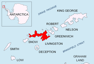 Location of Livingston Island in the South Shetland Islands | |
 Hetty Rock Location of Hetty Rock  Hetty Rock Hetty Rock (Antarctica) | |
| Geography | |
|---|---|
| Location | Antarctica |
| Coordinates | 62°40′05.6″S 60°43′54″W / 62.668222°S 60.73167°W |
| Archipelago | South Shetland Islands |
| Administration | |
| Administered under the Antarctic Treaty System | |
| Demographics | |
| Population | uninhabited |
Hetty Rock is the largest of several rocks in Walker Bay off John Beach in western Livingston Island in the South Shetland Islands, Antarctica. The area was visited by early 19th century sealers.
The feature is named after the British sealing ship Hetty under Captain Ralph Bond that operated in the South Shetlands in 1820-21.
Location
The rock is located at 62°40′05.6″S 60°43′54″W / 62.668222°S 60.73167°W which is 7.02 km (4.36 mi) east-northeast of Elephant Point, 1.92 km (1.19 mi) southeast of John Beach and 6.24 km (3.88 mi) west-southwest of Hannah Point (British mapping in 1935 and 1968, Chilean in 1971, Argentine in 1980, and Bulgarian in 2005 and 2009).
See also
Maps
- L.L. Ivanov et al. Antarctica: Livingston Island and Greenwich Island, South Shetland Islands. Scale 1:100000 topographic map. Sofia: Antarctic Place-names Commission of Bulgaria, 2005.
- L.L. Ivanov. Antarctica: Livingston Island and Greenwich, Robert, Snow and Smith Islands. Scale 1:120000 topographic map. Troyan: Manfred Wörner Foundation, 2009. ISBN 978-954-92032-6-4
References
External links

Topographic map of Livingston Island, Greenwich, Robert, Snow and Smith Islands.
This article is issued from
Wikipedia.
The text is licensed under Creative Commons - Attribution - Sharealike.
Additional terms may apply for the media files.