Devil Island
 Devil Island Antarctic Peninsula | |
| Geography | |
|---|---|
| Location | Antarctica |
| Coordinates | 63°48′S 57°17′W / 63.800°S 57.283°WCoordinates: 63°48′S 57°17′W / 63.800°S 57.283°W |
| Archipelago | James Ross Island group |
| Administration | |
|
None | |
| Administered under the Antarctic Treaty System. | |
Devil Island is a 128 ha, ice-free island about 2 km long, in the James Ross Island group near the north-eastern tip of the Antarctic Peninsula. It lies in a small cove 1 km north of Vega Island, east of the Trinity Peninsula. It is characterised by several low hills rising to a maximum height of about 150 m.[1]
Important Bird Area
The site has been identified as an Important Bird Area (IBA) by BirdLife International because it supports a large breeding colony of about 15,000 pairs of Adélie penguins. Other birds recorded as nesting there include brown skuas and snow petrels.[1]
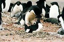
The island is an important breeding site for Adélie penguins
References
- 1 2 "Devil Island". BirdLife data zone: Important Bird Areas. BirdLife International. 2012. Archived from the original on 2007-07-10. Retrieved 2012-12-15.
This article is issued from
Wikipedia.
The text is licensed under Creative Commons - Attribution - Sharealike.
Additional terms may apply for the media files.