Tirunelveli district
| Tirunelveli district Nellai Mavattam, Nellai Seemai, Then Pandi Seemai, Then Pandi Nadu, Mudikonda Cholamandalam | |
|---|---|
| District | |
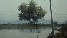
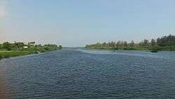 Thamirabarani River from Authoor Bridge | |
| Nickname(s): நெல்லை | |
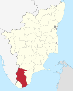 Location in Tamil Nadu, India | |
| Coordinates: 8°43′55″N 77°42′01″E / 8.73194°N 77.70028°ECoordinates: 8°43′55″N 77°42′01″E / 8.73194°N 77.70028°E | |
| Country |
|
| State | Tamil Nadu |
| District formed on | September 1, 1790 |
| Headquarters | Tirunelveli |
| Talukas | Alangulam, Ambasamudram, Nanguneri, Palayamkottai, Radhapuram, Sankarankoil, Shenkottai, Sivagiri, Tenkasi, Tirunelveli, Veerakeralamputhur, Cheranmahadevi, Kadayanallur, Manur, Thiruvenkatam |
| Government | |
| • Collector | Shilpa Prabhakar Satish, IAS |
| • Superintendent of Police | Dr. P.VE. Arunshakthi Kumar, IPS |
| Area | |
| • Total | 6,823 km2 (2,634 sq mi) |
| Population (2011)[1] | |
| • Total | 3,077,233 |
| • Density | 410.5/km2 (1,063/sq mi) |
| Languages | |
| • Official | Tamil |
| Time zone | UTC+5:30 (IST) |
| PIN | 627*** |
| Telephone code | 0462 |
| Vehicle registration |
TN-72 (Tirunelveli City) , TN-76 (Tenkasi Region) , TN-79 (Sankarankoil Region), TN-76A (Ambasamudram Region), TN-72A (Valliyur Region) |
| Coastline | 48.9 kilometres (30.4 mi) |
| Largest city | Tirunelveli |
| Sex ratio | M-49%/F-51% ♂/♀ |
| Literacy | 82.90% (2011) |
| Legislature type | elected |
| Legislature Strength | 11 |
| Precipitation | 814.8 millimetres (32.08 in) |
| Avg. summer temperature | 37 °C (99 °F) |
| Avg. winter temperature | 22 °C (72 °F) |
| Website |
www |
Tirunelveli District is a district of Tamil Nadu state in southern India. The city of Tirunelveli is the district headquarters. Tirunelveli District was formed on 1 September 1790[2][3] by the East India Company (on behalf of the British government), and comprised the present Tirunelveli and Thoothukudi districts and parts of Virudhunagar and Ramanathapuram districts. It is the second-largest district (as of October 2008), after Villupuram district. As of 2011, the district had a population of 3,077,233.
History
Under the rule of the Pandyan Dynasty, the district was known as Thenpandiyanadu. The Chola dynasty then named it Mudikonda Cholamandalam. The Madurai Nayaks called it Tirunelveli Seemai. Under the British East India Company, it was Tinnevelly district, which included the modern Tirunelveli and Thoothukudi districts and parts of the Virudhunagar and Ramanathapuram districts.
In 1910, Ramanathapuram District was formed from portions of the Madurai and Tirunelveli Districts, which comprised portions of the modern Virudhunagar District.
After the Independence of India, Tirunelveli District was bifurcated on 20 October 1986 to Nellai-Kattabomman district (Tirunelveli) and Chidambaranar district (Tuticorin). Subsequently, the Government of Tamil Nadu decided to name each district according to the name of the headquarters town, so the region's name changed from Tirunelveli-Kattabomman to Tirunelveli.[4]
Geography
The district is located in the southern part of Tamil Nadu. It borders Virudhunagar District to the north, Thiruvananthapuram, Kollam, Pathanamthitta and Idukki districts of Kerala to the west, Kanyakumari District to the south and Thoothukudi District to the east. The district covers an area of 6,823 square kilometres (2,634 sq mi). It lies between 8°05' and 9°30' north latitude and 77°05' and 78°25' east longitude.
The district contains mountains (a stretch of the Western Ghats) and lowland plains, including sandy soil and fertile alluvium, and a variety of flora, fauna and protected wildlife. The district also has inland and mountainous forests. Tirunelveli is said to be the only district of Tamil Nadu to have all the five types of ecological zones as described in the ancient Tamil Literature Kurunji (hilly), Mullai (Forest), Marutham (Flat fertile land), Neithal (area forming the seashore) and Palai (Dry desert lands).
Climate
Tirunelveli has rainfall in all seasons (953.1 millimetres (37.52 in) in 2005 and 2006), and benefits from both the northeast and southwest monsoons. Most precipitation came from the northeast monsoon (548.7 millimetres (21.60 in)) followed by the southwest monsoon (147.8 millimetres (5.82 in)) and summer rains (184.2 millimetres (7.25 in)). The district is irrigated by several rivers originating in the Western Ghats, such as the Pachaiyar River, which flows into the perennial Tambaraparani River. The Tambaraparani and Manimuthar Rivers have many dams, with reservoirs providing water for irrigation and power generation. The Tamiraparani River provides consistent irrigation to a large agricultural area.[5] The Chittar River also originates in this district. The Courtallam and Manimuthar waterfalls are the two major falls in the district.
Administration and politics
Tirunelveli is the Administration centre of Tirunelveli District, it is a part of the Tirunelveli Lok Sabha constituency.
Tirunelveli District has two Lok Sabha constituencies - Tenkasi,Tirunelveli and ten state assembly constituencies.
Leglislative Assembly Constituencies of Tirunelveli District:
Tenkasi (Lok Sabha constituency):
- Tenkasi
- Kadayanallur
- Sankarankovil (SC)
- Vasudevanallur (SC)
Note: There are two more assembly constituencies under Tenkasi (Lok Sabha constituency) viz Srivilliputhur and Rajapalayam - which are not part of the Tirunelveli district.
Demographics
According to 2011 census, Tirunelvei district had a population of 3,077,233 with a sex-ratio of 1,023 females for every 1,000 males, much above the national average of 929.[6] A total of 321,687 were under the age of six, constituting 164,157 males and 157,530 females. Scheduled Castes and Scheduled Tribes accounted for 18.51% and .33% of the population respectively. The average literacy of the district was 73.88%, compared to the national average of 72.99%.[6] The district had a total of 815,528 households. There were a total of 1,436,454 workers, comprising 107,943 cultivators, 321,083 main agricultural labourers, 215,667 in house hold industries, 626,714 other workers, 165,047 marginal workers, 7,772 marginal cultivators, 58,680 marginal agricultural labourers, 23,997 marginal workers in household industries and 74,598 other marginal workers.[7]
As per the religious census of 2011, Tirunelveli District had 78.82% Hindus, 9.85% Muslims, 11.12% Christians, 0.008% Sikhs, 0.012% Buddhists and 0.17% belonging to Other Beliefs & Groups.[8]
Infrastructure
The district is well-connected by a network of roads and railways. Tirunelveli city serves as the main junction. It has no airports; the nearest airports are at Tuticorin (40 kilometres (25 mi) away), Madurai (150 kilometres (93 mi)) and Thiruvananthapuram (158 kilometres (98 mi)). The district has a total of 27 railway stations. The tables below list the lengths of roads and railways in the district.[9]
| Roads | National highways | State highways | Corporation and Municipalities Roads | Panchayat Union and Panchayat Road | Town Panchayat and Townships Road | Others (forest roads) |
|---|---|---|---|---|---|---|
| Length (km.) | 174.824 | 442.839 | 1,001.54 | 1,254.10 and 1,658.35 | 840.399 | 114.450 |
| Railways | Route length (km) | Track length (km) |
|---|---|---|
| Broad gauge | 257.000 | 495.448 |
| Meter gauge | 0.000 | 0.000 |
Canals, wells, tanks and reservoirs are the sources of irrigation in the district. As of 2005–2006, the district had a total of 151 canals with a length of 499 kilometres (310 mi), 85,701 irrigation wells, 640 tube wells, eight reservoirs and 2,212 tanks. The district also has 21,776 wells used for domestic purposes.
Electricity is provided by the Tamil Nadu Electricity Board (TNEB).[9] The district has hydroelectric power plants and windmills, with an installed capacity of 1,089.675 megawatt-hours (3,922.83 GJ); it is one of the major producers of wind energy in the state.
The Koodankulam Nuclear Power Plant project is being undertaken (with Russian aid) at the village of Koodankulam, 24 kilometres (15 mi) north-east of Kanyakumari, 36 kilometres (22 mi) from Nagercoil and about 106 kilometres (66 mi) from Thiruvananthapuram . Koodankulam is also the location of hundreds of windmills used for power generation, eight of which are located inside the grounds of the nuclear plant. These wind turbines have currently a total capacity of 2000 MW and represent one of the largest wind farms in India. Since the beginning of 2011, this place has been embroiled in a nuclear plant controversy over fears of the plant safety.
Education and social development
Tirunelveli is known for its educational institutions, many of which are located at Palayamkottai (east of Tirunelveli). For this reason, Palayamkottai is known as the "Oxford of South India". The district has a literacy rate of 76.97%, which is above the state average. As of 2005–2006, the district had a total of 2,494 schools. It has one university, the Manonmaniam Sundaranar University. There are also four government colleges, eleven government-sponsored colleges and seven private colleges.[9]
Tirunelveli has the following educational institutions:
- Universities: 1[10]
- Arts and science colleges: 25
- Medical College: 1
- Siddha medical college: 1
- Veterinary College and Research institute
- Engineering colleges: More than 20
- Law school: 1
- Pre-kindergartens: 241
- Primary schools: 1,501
- Middle schools: 431
- High schools: 114
- Higher secondary schools: 185
- Teacher-training institutes: 28
University
It has Manonmaniam Sundaranar University (MSU), which was established in 1990. Named after poet Sundaram Pillai, the university has a network of 102 affiliated colleges. Many of these colleges have contributed to higher education for decades; five colleges are more than 100 years old. The University campus is located at Abishekapatti, 9 kilometres (5.6 mi) from Tirunelveli town. Advanced studies are offered in a number of departments, and postgraduate programmes in Tamil, Management studies, Chemistry, Communications, Computer science, English, Environmental studies, History, Mathematics, Physics, Sociology, Criminology studies, Psychology and Statistics are offered.
The university has introduced compulsory core courses in Indian studies. The curriculum includes "History of Freedom Movement in India", "Gandhian Thought", "Ecology, Environment and Pollution Studies", "Status of Women in India", "History of Science", "Indian Economy Since Independence", "Rural India", "Consumer Protection and Social Responsibility in Business" and "Secularism". It has set up a centre for environmental studies at Alwarkurichi in collaboration with the Amalgamations corporation. Eco-friendly ventures in aquaculture and fishing are encouraged. The centre has developed an organic manure, "Mano compost".
Collegiate education
In 1878, there were two colleges in the district: the Madurai Diraviam Thayumanavar Hindu College and St. John’s College. The first college for women (and third college of the district), Sarah Tucker College, began in 1895. The fourth and fifth colleges, St. Xavier’s and St. Ignatius Colleges of Education, were established in 1923 and 1957, respectively. In 1963–64, two more colleges, the Paramakalyani and Parasakthi Colleges, were added. The Ambai Arts and Thiruvalluvar Colleges (1969), Muthuramalinga Thevar College and Government Arts College for Women (1970), and the Sadaktathullah Appa and T.D.M.N.S. Colleges (1971) followed. Except for the Government Arts College for Women, all of the schools are private colleges run by educational trusts. There are three self-financing colleges: Saratha College for Women (1986), Sattanathakarayalar College (1994–1995) and Jayaraj Annabakkiam College (1997–1998).
Of the 17 arts colleges in the district, eight are coeducational institutions, five are for women and four for men. The colleges in Tirunelveli district were originally affiliated with the University of Madras. Upon the creation of Madurai Kamaraj University in 1966, they were affiliated with MKU from 1966 to 1990. In 1990, their affiliation transferred to Manonmaniam Sundaranar University. The university has granted autonomous status to St. Xavier’s College in Palayamkotti and Sri Parasakthi College for Women in Courtallam.
The Regional Directorate of the Collegiate Education in the district was formed on 10 September 1979 to regulate colleges in Tirunelveli, Thoothukudi and Kanyakumari districts.
School districts
In 1986, the Revenue District of Tirunelveli was divided into Tirunelveli and Thoothukkudi districts. A new post, District Educational Officer at Tenkasi, was created. The office of "District Educational Officer, Tirunelveli Central" was changed to "District Education Officer, Tirunelveli"; the "District Educational Officer, Tirunelveli South" was redesignated "District Educational Officer, Cheranmahadevi". The three District Education Officers serve under the Chief Education Officer.
| Education officials | Jurisdiction |
|---|---|
| District Educational Officer, Tirunelveli | Taluks of Tirunelveli, Palayamkottai and Sankarankovil |
| District Educational Officer, Cheranmahdevi | Taluks of Ambasamudram, Nanguneri and Radhapuram |
| District Educational Officer, Tenkasi | Taluks of Tenkasi, Shencottai, Alangulam, VK Pudur and Sivagiri |
| District Adult Education Officer | Entire district |
| District Elementary Educational Officer | Entire Tirunelveli district (primary and upper-primary schools) |
| Assistant Elementary Educational Officers (21) | One for each of the 19 panchayat unions and two for urban areas |
| Additional Assistant Elementary Educational Officers (21) | One for each of the 19 panchayat unions and two for urban areas |
Legal education
In 1996, the Government Law College, Tirunelveli was established to meet the requirements of the people of the southernmost part of Tamil Nadu. It opened on 14 October 1996 with 80 students in its three-year law course affiliated to Manonmaniam Sundaranar University as the fifth institution of its kind in the state. Since the academic year 1997–98, the college is affiliated with the Tamil Nadu Dr. Ambedkar Law University, Chennai. At first, classes were held at the Ponnusamy Pillai Bungalow on Tiruchendur Road in Palayamkottai before its new building was constructed. The College has functioned in its own new building in an area of 15 acres adjacent to District Court Buildings on the Tiruchendur High Road since October 2000.
Another milestone in the history of this college when M.L Degree in Constitutional Law and Human Rights was started in 1997. A five-year B.L. course was introduced in the academic year 2000–01. As directed by the Bar Council of India, a semester system was introduced for both (three years and five years) Law Courses, beginning with the academic year 2002–2003.
Medical education
The Tirunelveli Medical College and its teaching hospital are located on about 280 acres of land at High Grounds, Palayamcottai. It was established in 1965 and affiliated with the University of Madras, with 75 students for the academic year 1965–1966. These students took their first-year courses at local arts and science colleges. In July 1966, the first group of second-year MBBS students attended the classes in the newly constructed Anatomy Block. Other departments (such as pharmacology, pathology, microbiology and social and preventive medicine) began in subsequent years and the district-headquarters hospital was converted to Tirunelveli Medical College Hospital. The college was affiliated with Madurai Kamaraj University after its inception in 1967. Since 1988, upon the formation of The TN Dr MGR Medical University, Chennai, it has been affiliated with that university. The college was recognised by the Medical Council of India, New Delhi in 1978. The number of seats for the MBBS course was increased from 75 to 100 in 1980, and that year the state government also authorised postgraduate courses. The college celebrated its silver jubilee in 1990. The number of MBBS seats offered was increased to 150 seats in 2003 and was recognised in 2008 (like Madras Medical College, Government Stanley Medical College, and Madurai Medical College).
The Government Siddha Medical College was established at Palayamkottai on 30 November 1964. This was an affiliated College of the University of Madras until March 1966; from then until 1988 it was an affiliate of Madurai Kamaraj University, and since March 1989 of Dr. MGR Medical University.
Technical education
Technical education in the district dates to 1844, when Mrs. Caldwell (wife of Bishop Robert Caldwell) began a school to teach girls lace-making at Idyangudi. The government of Tamil Nadu set up a State Board of Technical Education and Training and a separate Directorate of Technical Education, effective 1 October 1957. Since then, the Directorate of Technical Education has assumed the administration of both engineering colleges and polytechnics.
The Government College of Engineering was established in October 1981 to fulfill the needs of people in the southern region. At first, the college met in a bungalow near Tirunelveli Medical College, while new buildings were under construction. In 1984, the college moved into the new buildings on its 25-hectare (62-acre) campus, about 8 km from Tirunelveli Junction on the Tirunelveli-Trivandrum Highway. From its inception, the College admitted students in three undergraduate departments: civil, electronics and communication and mechanical engineering; electrical and electronics engineering was introduced during 1986–1987, and computer science and engineering was added in 1989–1990. A postgraduate course in computer science and engineering was introduced in 1994–1995.. It also have post graduate courses in Engineering design and power electronics.
Economy
Tirunelveli has been an agricultural area throughout its history. The district is a major producer of rice, coconuts, bananas, spices and forest-based products. The district is home to almost 50% of the buffalo population of Tamil Nadu.[11] The district's livestock and poultry populations are as follows:[9]
| Cattle | Buffalo | Sheep | Goats | Pigs | Horses and Ponies | Donkeys | Rabbits | Total livestock | Total poultry |
|---|---|---|---|---|---|---|---|---|---|
| 418,694 | 78,777 | 487,273 | 390,570 | 12,752 | 245 | 961 | 2401 | 67,877 | 1,218,583 |
Since it is a coastal district, Tirunelveli is also involved in fishery development and production. For the period 2005–2006, the total inland fish catch was 1,874 tonnes, and the total marine fish catch was 7,014 tonnes.[9]
India Cements Limited is the third largest cement company in India, and began at Sankarnagar in Tirunelveli in 1949.
The district is also rich in minerals, with a total of 407 mines and quarries. Limestone, granite and garnet sand are some of the minerals mined or produced in the district. Major industries include textile, food and forestry products.
A Special Economic Zone (SEZ) was introduced at Nanguneri in 2001. A pharma park and windmill spare-parts and television-manufacturing factories have been planned in this SEZ. The Tamil Nadu Industrial Development Corporation (TIDCO) has planned a Rs 700-crore high-tech industrial park in Nanguneri in association with INFAC Group and Axes Technologies Inc of the US.[12][13] The state government is planning light manufacturing, design and assembly facilities, modern infrastructure facilities and amenities in this SEZ to attract a workforce from around the world.
Recreation
Manjolai Hills
Located between 1,000 metres (3,300 ft) and 1,500 metres (4,900 ft) of elevation, the Manjolai area is set deep within the Western Ghats within the Kalakad Mundanthurai Tiger Reserve in the Tirunelveli District. Located on top of the Manimuthar Dam and the Manimuthar Water Falls, the Manjolai area comprises tea plantations, small settlements, the Upper Kodaiyar Dam and a windy view point called Kuthiravetti.
The whole of the Manjolai Estates and the tea plantations are operated by The Bombay Burmah Trading Corporation Ltd on forest land leased by the Government of Tamil Nadu. There are three tea estates within the Manjolai area: Manjolai Estate, Manimutharu Estate and Oothu Estate. The Estates are located at elevations ranging from 700 metres (2,300 ft) to 1,300 metres (4,300 ft).
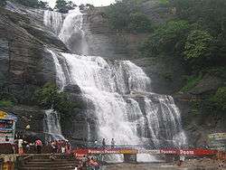
Courtallam
Courtallam is situated at a mean elevation of 160 metres (520 ft) on the Western Ghats in Tirunelveli District of Tamil Nadu, India. The numerous waterfalls and cascades along with the ubiquitous health resorts in the area have earned it the title of "Spa of South India". The falls are fullest with rain on the hills. They are Main Falls, Five Falls, the Shenbhaga Falls, the Tiger Falls, old Courtallam Falls, Honey Falls, Orchard falls and Sitraruvi.[14]
Tiger Reserve
The 900 square kilometres (350 sq mi) Kalakkad Mundanthurai Tiger Reserve was established in 1988. The reserve, at 8°39′N 77°23′E / 8.650°N 77.383°E, is about 45 km west of Tirunelveli and is known as KMTR to forest and tiger researchers. Kalakkad is the nearest town. Kalakkad has a temple called Malainambi temple with a falls.
Papanasam
Papanasam is a famous picnic spot in Tirunelveli district in the Indian state of Tamil Nadu. It falls under the Ambasamudram Taluk and is situated 50 km from Tirunelveli. The site is popular for its tourists attractions such as the Thamirabarani River, Agasthiyar Falls, the Shiva Temple, Papanasam dam and the hydroelectric power plant.
Bird Sanctuary
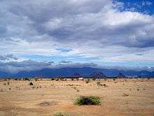
A tiny village in the far south, Koonthankulam in Nanguneri Taluk of Tirunelveli District is emerging as a new favourite of the migratory birds. It is just 38 kilometres (24 mi) away. About 35 species of birds visit this calm but congenial village for breeding. The painted storks are coming from North India and East European Countries to this place. Similarly the flamingoes which flew in mainly from the Rann of Kutch have hatched and reared their young in the village.[14]
Sankarankovil
Sankaranayinarkoil temple was built in the early part of the 11th century C.E. The temple at Sankarankovil depicts Hari (Lord Vishnu) and Hara (Lord Shiva) as one God. There is a deity named Sankara Narayanar who is half Lord Shiva and half Lord Vishnu. There is another deity named Avodai ambal or Gomathi Ambal, after whom the temple is named. It was built by King Ukrama Pandiyan in 900 C.E. The sand in this region is believed by some to have curative powers. August is marked by the Adi Thabasu festival.[14]
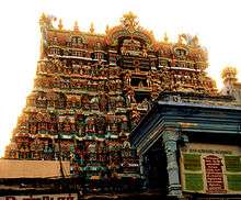
Swamy Nellaiappar and Kanthimathi Ambal Temple
The Nellaiappar Temple is located at Tirunelveli. It is rooted in tradition and history, and is known for its musical pillars and other sculpted figures.[15] The nearest airport is Tuticorin Airport (TCR) at Vagaikulam, a 30-minute drive (32 km) from Tirunelveli.[14]
Melaseval Navaneethakrishnan Temple
The Navaneethakrishnan Temple at Melasevel Village, 16 km from Tirunelveli Town on the road leading to Ambasamudram, is around 730 years old. Adhithyavarneshwar Temple, devoted to Lord Shiva is also famous in this village. Twice a year, the sun's rays fall straight on the Lingam in the morning. Annual festivals are conducted at both these temples by people to whom the deity is kuladeivam (family deity). Dolotsavam utsavam on every month, on the day of Star ROHINI at the Navaneethakrishnan temple is quite familiar, and many childless couples take part in this pooja. Garuda Sevai is conducted on all four Saturdays of the Tamil month of Purattasi and attracts a large number of devotees from the neighbouring villages. With the kind permission of the HRE department of the State Government, the Melaseval Bhaktha Jana Seva Trust maintains the temple with daily rituals and regular poojas. The Uriyadi festival during Krishnashtami is an important event in this small village.
Gallery
 Courtallams Falls
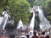 Five falls
 Old Courtallam
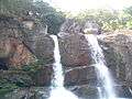 Chenbahadevi falls
 Tiger falls
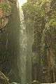 Honey falls
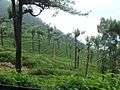 Manjolai hills
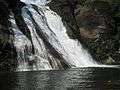 Vanatheertham falls at Papanasam
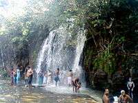 Agastiyar falls
 Manimuthar
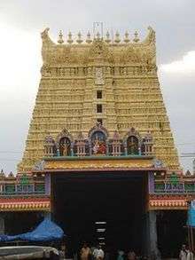 Sankarankovil temple
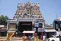 Nellaiappar temple
_at_Koonthakulam_Bird_Sanctuary.jpg) Bird Sanctuary Koonthakulam
Bird Sanctuary Koonthakulam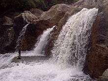 Manimuthar falls
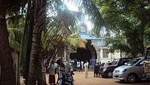 Sivasailam Temple
 Gadananathi River or Karunai river dam
See also
References
- ↑ "2011 Census of India" (Excel). Indian government. 16 April 2011.
- ↑ http://www.edreamsinetcafe.in/tirunelveli/history.htm%5Bpermanent+dead+link%5D
- ↑ "Archived copy". Archived from the original on 25 October 2009. Retrieved 22 October 2009.
- ↑
- ↑ "Tirunelveli District Irrigation". Archived from the original on 8 September 2006. Retrieved 24 September 2006.
- 1 2 "Census Info 2011 Final population totals". Office of The Registrar General and Census Commissioner, Ministry of Home Affairs, Government of India. 2013. Retrieved 26 January 2014.
- ↑ "Census Info 2011 Final population totals – Tirunelveli district". Office of The Registrar General and Census Commissioner, Ministry of Home Affairs, Government of India. 2013. Retrieved 26 January 2014.
- ↑ "Population By Religious Community - Tamil Nadu" (XLS). Office of The Registrar General and Census Commissioner, Ministry of Home Affairs, Government of India. 2011. Retrieved 13 September 2015.
- 1 2 3 4 5 Microsoft Word – Format.doc
- ↑ http://www.collegesintamilnadu.com/Education_News/20114/20111214c.asp
- ↑ Tamil Nadu animal-husbandry report Retrieved 15 September 2011.
- ↑ "The Hindu Business Line : TN plans to reorient Nanguneri SEZ with Tuticorin". Archived from the original on 3 December 2007. Retrieved 12 November 2007.
- ↑ Nanguneri.Com India Portal
- 1 2 3 4
- ↑ Tirunelveli District, National Informatics Centre, Tirunelveli Tourism & Places of Importance
External links
| Wikimedia Commons has media related to Tirunelveli district. |
| Wikivoyage has a travel guide for Tirunelveli. |
| State symbols |
|
|---|---|
| Governance |
|
| Topics | |
| Districts |
|
| Major cities | |