Chittar, Kerala
| Chittar | |
|---|---|
| town/village | |
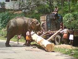 An Elephant used to load timber in Chittar | |
 Chittar Location in Kerala, India  Chittar Chittar (India) | |
| Coordinates: 9°19′58″N 76°55′58″E / 9.33278°N 76.93278°ECoordinates: 9°19′58″N 76°55′58″E / 9.33278°N 76.93278°E | |
| Country |
|
| State | Kerala |
| District | Pathanamthitta |
| Government | |
| • Type | Democratic |
| • Body | Chittar grama panchayath |
| Area | |
| • Total | 25.9 km2 (10.0 sq mi) |
| Population (2001) | |
| • Total | 33,977 |
| • Density | 1,300/km2 (3,400/sq mi) |
| Languages | |
| • Official | Malayalam, English |
| Time zone | UTC+5:30 (IST) |
| PIN | 689663 |
| Telephone code | 04735 |
| Vehicle registration | KL-62, KL-03 |
| Coastline | 0 kilometres (0 mi) |
| Nearest city | Vadasserikkara, Angamoozhy |
| Climate | Tropical summer (Köppen) |
| Avg. summer temperature | 35 °C (95 °F) |
| Avg. winter temperature | 18 °C (64 °F) |
| Website | lsgkerala.in/chittarpanchayat/ |
Chittar is a village in Pathanamthitta district, located in Kerala state, India. It is a Panchayat and is situated in the Ranni taluk and in Konni constituency in Pathanamthitta District. It is located 29 km away from Pathanamthitta town at its east. Nearby Panchayats are Seethathodu, Perunad, Vadaserikkara and Thannithodu. Formerly Chittar was included in the Ranni legislative assembly constituent, but now in Konni assembly. Also previous parliament constituent was Idukki and currently it is Pathanamthitta.Chittar also awarded' Nirmal gram ' award from former president Prathibha patel.
Economy
Chittar is predominantly a plantation township. Earlier famed for tea/coffee plantations, nowadays swaying rubber trees have replaced them, fuelled by the fertile land and rich ecosystem. In addition to rubber cultivation, pineapple, tapioca, nuts, ginger, and pepper are cultivated. It was once a part of the demolished Nilakkal trade centre.
Location
Chittar lies in the eastern part of Pathanamthitta district and bordered by Perunad panchayath in north, Thannithodu in south, Vadasserikkara in west and Seethathodu in east.
Administration
The panchayath of Chittar was formed in 30 September 1970 by partitioning the Vadaseerikkara and Seethathodu panchayaths in Ranni taluk. For administrative convenience, the panchayath is divided into 13 wards.
- Pambini
- Panniyar
- Manakkayam
- Chittar
- Chittar thottam
- Meenkuzhi
- Kulangaravali
- Vayyattupuzha
- Manpilavu
- Neelipilavu
- Kattachira
- Chittar thekkekkara
- Kodumudi[1]
Education
Chittar has one Government High School, two higher secondary education facilities, in addition to several middle schools and lower primary schools.Chittar also have college also.
Important schools:
- Govt. L.P.S. Chittar Estate
- L.P.School Neeliplavu,
- Holy Family Public School,
- Govt. H. S. S., Chittar,
- Govt. Model L. P. S., Chittar,
- V. K. N. M. V. H. S. S, Vayyattupuzha
- Komala Vilasm School, Padayanippara
- Little Angels English Medium High School
- Royal Parallel College, Chittar
- Santhinikethan College chittar.
Nearby Colleges:
- SNDP Arts College, Ettichuvadu - Meenkuzhi,chittar
- Caarmel Engineering College, R-Perunad
- Ideal Parallel College, Chittar
- Musalliar Engineering College, *Malayalappuzha
- Mount Zion Engineering College, Kadammanitta
- Pushpagiri Medical College, Tiruvalla
- Muthoot Nursing College, Pathanamthitta
- St. Thomas College, Ranni,
- Catholicate College, Pathanamthitta
- Mar Ivanios ITC, Seethathodu
Population
The people of Chittar are mainly agriculturists and plantation workers. People began settling down in Chittar about 75 years ago. The people mainly belong to Hindu, Christian and Muslim religions. People live together in good harmony. There are several places of religious worship in Chittar. In many of the families based in Chittar, there are large numbers of people working outside Kerala as well as outside India. The new generation is highly educated and well placed in different parts of the world.
As of 2001 India census, Chittar had a population of 33977 with 16498 males and 17479 females.[2]
See also
References
- ↑ "LSGI Election 2010". www.lsgkerala.gov.in. Retrieved 2016-11-29.
- ↑ "Census of India : Villages with population 5000 & above". Registrar General & Census Commissioner, India. Archived from the original on 2008-12-08. Retrieved 2008-12-10.
| Wikimedia Commons has media related to Chittar. |