Andal, Paschim Bardhaman
| Andal | |
|---|---|
| Census Town | |
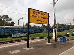 Andal Jn. railway station | |
 Andal Location in West Bengal, India | |
| Coordinates: 23°36′N 87°12′E / 23.60°N 87.20°ECoordinates: 23°36′N 87°12′E / 23.60°N 87.20°E | |
| Country |
|
| State | West Bengal |
| District | Paschim Bardhaman |
| Elevation | 76 m (249 ft) |
| Population (2011) | |
| • Total | 19,924 |
| Languages | |
| • Official | Bengali, English |
| Time zone | UTC+5:30 (IST) |
| Lok Sabha constituency | Asansol |
| Vidhan Sabha constituency | Raniganj |
| Website |
bardhaman |
Andal (also spelled Ondal) is a census town, and location of a police station, in Andal CD Block in Durgapur subdivision of Paschim Bardhaman district in the Indian state of West Bengal.
Geography
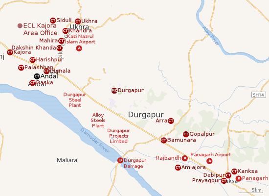 |
| Cities and towns in the southern portion of Durgapur subdivision in Paschim Bardhaman district MC: Municipal Corporation, CT: census town, R: rural centre, A: airport, B: barrage Owing to space constraints in the small map, the actual locations in a larger map may vary slightly |
Location
Andal is located at 23°36′N 87°12′E / 23.60°N 87.20°E. It has an average elevation of 76 metres (249 feet).
The Asansol-Durgapur region is composed of undulating laterite soil. This area lies between two mighty rivers – the Damodar and the Ajay. They flow almost parallel to each other in the region – the average distance between the two rivers is around 30 km. For ages the area was heavily forested and infested with plunderers and marauders. The discovery of coal in the 18th century led to industrialisation of the area and most of the forests have been cleared.[1]
Singaran, a small stream about 35 km long has its origin near Ikra in the Jamuria area, flows past Topsi and Andal and joins the Damodar near Waria.[2]
Urbanisation
As per the 2011 census, 79.22% of the population of Durgapur subdivision was urban and 20.78% was rural. Durgapur subdivision has 1 municipal corporation at Durgapur and 38 (+1 partly) census towns (partly presented in the map alongside; all places marked on the map are linked in the full-screen map).[3]
Andal, a part of Andal (gram), Dignala, Palashban and Baska lying south of NH 19 (old numbering NH 2)/ Grand Trunk Road form a cluster of census towns. This cluster is linked to a cluster of census towns located north of NH 19.[4]
Police station
Andal police station has jurisdiction over parts of Andal CD Block. The area covered is 106 km2 and the population covered is 236,000.[5][6]
Demographics
As per 2011 Census of India Ondal had a total population of 19,924 of which 10,321 (52%) were males and 9,603 (48%) were females. Population below 6 years was 2,176. The total number of literates in Ondal was 14,613 (82.34% of the population over 6 years).[7]
As of 2001 India census, Andal had a population of 19,504. Males constitute 53% of the population and females 47%. Andal has an average literacy rate of 75%, higher than the national average of 59.5%: male literacy is 81%, and female literacy is 68%. In Andal, 11% of the population is under 6 years of age.[8]
Transport
Road
Andal is on the Grand Trunk Road or NH 19, now part of the Golden Quadrilateral. It is easily approachable from all other cities and towns in the region.
Rail
The best option to communicate Andal through Rail Station named as Andal railway station. It is on the Howrah-Delhi track and is linked with Sainthia through the Andal-Sainthia branch line.

Asansol division of Eastern Railway has the largest goods yard at Andal. The marshalling of wagons is done by a hump yard fitted with mechanical retarders.[9]
Kazi Nazrul Islam Airport
The Union Civil Aviation Ministry and the West Bengal Government announced on 7 September 2007 plans to set up a new airport — along with a township, IT and logistics hub — at Durgapur-Andal Region. This earmarked the beginning of the Aerotropolis Project in Andal. Spread over approximately 2,182 acres (8.83 km2), the Durgapur Aerotropolis Project is shaping up in the Asansol Durgapur Planning Area (ADPA) of Burdwan District in West Bengal.
An Integrated Township, IT Park and Logistics Hub will see the light of the day along with the Durgapur Aerotropolis Project. These will help in enhancing the growth prospects of Durgapur. BAPL has completed most of its legal procedures like receiving the In-Principal Clearance from the Ministry of Civil Aviation and getting the Land Use Development Control Plan (LUDCP) approved by Asansol Durgapur Development Authority (ADDA). It has also entered into a Technical Services Agreement with Changi Airports India Pte Ltd, Singapore. In the area both Burnpur and Durgapur have airstrips for the landing of small planes. The airfield at Panagarh is under Indian Air Force.
The honourable chief minister of West Bengal, Mamata Banerjee announced on 25 May 2013 (Nazrul Islam's Birth Anniversary) that she has proposed to name the airport at Durgapur after the iconic Indian Bengali poet, author, musician, freedom fighter and the National poet of Bangladesh, Kazi Nazrul Islam. This has been a matter of great joy and pride for the people. [10]
Politics & Social life
In the 1957 General Elections, Ondal was a dual constituency. While Ananda Gopal Mukherjee of INC won the open seat, Dwajadhari Mondal of INC won the seat reserved for Scheduled Castes. Dr.Chandi Charan Mukherjee was one of the most well known person.He died on Thursday 4th July 1974. His Grandson Sri Tara Prasad Mukherjee is also a well known Social Worker.[11] For election results in other years for the area see Ausgram and Durgapur
As per orders of the Delimitation Commission, from 2011 Andal community development block is part of Raniganj (Vidhan Sabha constituency).[12]
Education
Andal has seven primary, four secondary and three higher secondary schools,[13] including Andal Hindu Hindi vidyalaya which is the biggest Hindi medium school in the area. Also having an Eastern Railways owned school E.Rly. High School, Andal and a Kendriya Vidyalaya. Andal has a Bengali medium high school named Ondal High School. There are two English medium secondary schools named St. Mary's (Station Road) and St. Francis Xavier School. One of the Urdu medium schools is Iqbal Academy High school.
Healthcare
There is a primary health centre at Andal.[14]<
See also
References
- ↑ Chattopadhyay, Akkori, Bardhaman Jelar Itihas O Lok Sanskriti (History and Folklore of Bardhaman District.), (in Bengali), Vol I, pp 14-15, Radical Impression. ISBN 81-85459-36-3
- ↑ Chattopadhyay, Akkori, p34
- ↑ "District Statistical Handbook 2014 Burdwan". Table 2.2, 2.4(a). Department of Statistics and Programme Implementation, Government of West Bengal. Retrieved 15 September 2018.
- ↑ "District Census Handbook Bardhaman, Series 20, Part XII A, Census of India 2011" (PDF). Map of Ondal CD Block, page 229. Directorate of Census Operations, West Bengal. Retrieved 16 September 2018.
- ↑ "District Statistical Handbook 2014 Bardhaman". Tables 2.1, 2.2. Department of Statistics and Programme Implementation, Government of West Bengal. Retrieved 23 September 2018.
- ↑ "Asansol Durgapur Police Commissionerate". Find your police station. Asansol Durgapur Police. Retrieved 18 February 2017.
- ↑ "2011 Census – Primary Census Abstract Data Tables". West Bengal – District-wise. Registrar General and Census Commissioner, India. Retrieved 20 February 2017.
- ↑ "Census of India 2001: Data from the 2001 Census, including cities, villages and towns (Provisional)". Census Commission of India. Archived from the original on 2004-06-16. Retrieved 2008-11-01.
- ↑ Eastern Railway – Asansol Archived 23 July 2011 at the Wayback Machine.
- ↑ "New airport planned near Durgapur". The Hindu Business Line, 8 September 2007. Archived from the original on 30 September 2007. Retrieved 2007-09-08.
- ↑ "Statistical Report on General Elections 1957 to the Legislative Assembly of West Bengal" (PDF). Election Commission of India. Archived (PDF) from the original on 7 March 2008. Retrieved 2008-01-26.
- ↑ "Delimitation Commission Order No. 18" (PDF). Government of West Bengal. Archived from the original (PDF) on 18 September 2010. Retrieved 2010-08-21.
- ↑ (Eastern Rail way High School)7th All-India School Education Survey 2003 Archived 2007-09-27 at the Wayback Machine.
- ↑ "Bardhaman district". Medical Institutions. Bardhaman district administration. Retrieved 6 March 2017.
External links
Cities, towns and locations in Paschim Bardhaman district | |||||
|---|---|---|---|---|---|
| Cities, municipal and census towns | |||||
| Locations other than cities and towns |
| ||||
| Neighbourhoods in Asansol |
| ||||
| Related topics |
| ||||