Arendal
| Arendal kommune | |||
|---|---|---|---|
| Municipality | |||
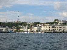
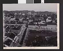
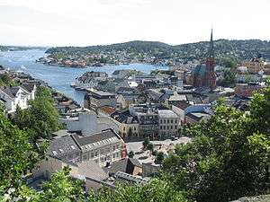 View of Arendal's city centre (2006) | |||
| |||
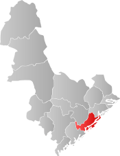 Arendal within Aust-Agder | |||
| Coordinates: 58°28′56″N 08°46′57″E / 58.48222°N 8.78250°ECoordinates: 58°28′56″N 08°46′57″E / 58.48222°N 8.78250°E | |||
| Country | Norway | ||
| County | Aust-Agder | ||
| District | Sørlandet | ||
| Administrative centre | Arendal | ||
| Government | |||
| • Mayor (2015) | Robert Cornels Nordli (Ap) | ||
| Area | |||
| • Total | 270.21 km2 (104.33 sq mi) | ||
| • Land | 255.14 km2 (98.51 sq mi) | ||
| • Water | 15.07 km2 (5.82 sq mi) | ||
| Area rank | #288 in Norway | ||
| Population (2017) | |||
| • Total | 44,576 | ||
| • Rank | #20 in Norway | ||
| • Density | 174.7/km2 (452/sq mi) | ||
| • Change (10 years) | 11.3% | ||
| Demonym(s) | Arendalitt[1] | ||
| Time zone | UTC+01:00 (CET) | ||
| • Summer (DST) | UTC+02:00 (CEST) | ||
| ISO 3166 code | NO-0906 | ||
| Official language form | Bokmål | ||
| Website |
www | ||
Arendal (Urban East Norwegian pronunciation: [²ɑːɳ̍ɖɑːl] (![]()
The 270-square-kilometre (100 sq mi) municipality is the 288th largest by area out of the 422 municipalities in Norway. Arendal is the 20th most populous municipality in Norway with a population of 44,576. The municipality's population density is 174.7 inhabitants per square kilometre (452/sq mi) and its population has increased by 11.3% over the last decade.[3]
General information
Municipal history
The town of Arendal was established as a municipality on 1 January 1838 (see formannskapsdistrikt). On 1 January 1875, a small area with 22 inhabitants was transferred from the town to the neighboring municipality of Østre Moland and another small area with 52 residents was transferred to the neighboring municipality of Øyestad.[4]
On 1 January 1902, the rural municipality of Barbu (population: 6,787) was merged into the town of Arendal. In 1944, a small area of Moland with a population of 21 inhabitants was transferred to Arendal as well. On 1 January 1992, the town was vastly expanded. The neighboring rural municipalities of Hisøy (pop: 4,026), Moland (pop: 8,148), Tromøy (pop: 4,711), and Øyestad (pop: 8,679) were all merged with the town of Arendal which had a population of 12,478, bringing the total population of the new municipality of Arendal to 38,042.[4]
Origin of the name
The Old Norse form of the name was probably Arnardalr. The first element is the genitive case of ǫrn which means "eagle" and the last element is dalr which means "valley" or "dale", thus meaning the "eagle valley".[2]
Coat-of-arms
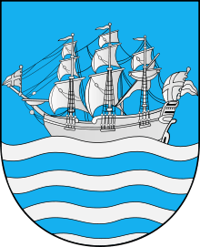
The coat-of-arms of Arendal were granted on 7 November 1924 (based upon an older seal). The blue and silver arms show a sailing ship as a symbol for the importance of fisheries and sailing to the local economy. A ship appeared on the oldest known seal of the town, dating back to the 17th century. In the late 19th and early 20th century the arms showed the ship in the upper part and a landscape with the coat of arms of Norway in the base of the shield.[5][6]
Churches
The Church of Norway has six parishes (sokn) within the municipality of Arendal. It is part of the Arendal prosti (deanery) in the Diocese of Agder og Telemark.
| Parish (Sokn) | Church Name | Location of the Church | Year Built |
|---|---|---|---|
| Barbu | Barbu Church | Barbu | 1880 |
| Hisøy | Hisøy Church | His | 1849 |
| Moland | Austre Moland Church | Brekka | 1673 |
| Flosta Church | Flostaøya | 1632 | |
| Stokken Church | Saltrød | 1878 | |
| Trefoldighet | Trinity Church | Arendal | 1888 |
| Tromøy | Færvik Church | Færvik | 1884 |
| Tromøy Church | Brekka | c. 1150 | |
| Øyestad | Bjorbekk Church | Bjorbekk | 1884 |
| Engene Church | Nedenes | 1849 | |
| Øyestad Church | Rykene | c. 1200 |
History
The village of Arendal was established in the middle of the 16th century, and was then called Arendall. Initially, it had no formal town status.
When the town of Christianssand was founded by King Christian IV in 1641, he granted the citizens a monopoly on all trade in Nedenæs and Lister og Mandal counties (including the area of Arendal). This grant, intended to subsidize Christianssand and its fortifications, placed existing towns in a difficult position. Both towns and the peasants in the rural countryside protested the hardships this caused. As a result, Arendal received royal permission in 1622 to continue as a loading-place for timber until a means could be found to transfer its trade to Christianssand.
The town of Arendal was given market city privileges in 1723. However the peasants in the surrounding district, who by law were to sell their goods only at Arendal, were smuggling their goods out on cutters and selling them in Denmark, in the Baltic, and in Britain.
This continued until 1735, when Arendal was granted a full town charter. This charter, combined with Danish imposition of a monopoly on grain imports, caused great poverty and starvation among the peasants in the surrounding districts, leading to several famous rebellions.
As a result of the rebellions, the age of privileges for towns like Christianssand and Arendal came to an apparent end in 1768 by royal proclamation. But the problems did not end then; a farmer, Christian Jensen Lofthuus, in nearby Vestre Moland led a rebellion in 1786 which resulted in the government actually remedying some of the most repressive trade policies, but Lofthus died in prison. The charges against Lofthus were that he dealt in grain and other commodities to the detriment to Arendal's privileges.
Shipping, shipbuilding, and timber trade as well as mining and ironworks were important branches of industry in Nedenæs county for many centuries, especially in the Arendal region. Frequent contacts with the world abroad put their mark on our culture and traditions. In 1880, it was the country's biggest port in terms of tonnage handled. At the end of the 19th century, Arendal was recognized as a major shipping centre with many wealthy shipowners. However, this came to an end following the 1886 Arendal crash, in which Axel Nicolai Herlofson had defrauded many bank customers in the city, leading to bankruptcies and extreme unemployment.[7]
Around the turn of the twentieth century, when thousands of Norwegians sought to take advantage of the more stable economic climate of the United States by emigrating, many of those from Arendal took their economic traditions with them. In New York City and the surrounding areas, a great deal of Americans who claim Norwegian ancestry can trace their roots to Arendal, as a great deal of Norwegian sailors, trimmers, shipbuilders, and carpenters from Arendal settled in areas of New York such as Brooklyn, Port Richmond (Staten Island), and several industrial centers in northern New Jersey such as Jersey City, Bayonne, Perth Amboy, and Elizabeth. In 1939, Arendal had the 4th largest Norwegian tanker fleet; only Oslo, Bergen, and Stavanger were larger.
During the German invasion of Norway on 9 April 1940, Arendal was captured by the German torpedo boat Greif.[8]
Today, the town has small boat manufacturing, mechanical industry, electronics industry, as well as one of the world's largest silicon carbide refining plants.
Government
All municipalities in Norway, including Arendal, are responsible for primary education (through 10th grade), outpatient health services, senior citizen services, unemployment and other social services, zoning, economic development, and municipal roads. The municipality is governed by a municipal council of elected representatives, which in turn elect a mayor.
Municipal council
The municipal council (Kommunestyre) of Arendal is made up of 39 representatives that are elected to four year terms. Currently, the party breakdown is as follows:[9]
| Party Name | Name in Norwegian | Number of representatives | |
|---|---|---|---|
| Labour Party | Arbeiderpartiet | 15 | |
| Progress Party | Fremskrittspartiet | 6 | |
| Conservative Party | Høyre | 8 | |
| Christian Democratic Party | Kristelig Folkeparti | 3 | |
| Green Party | Miljøpartiet De Grønne | 1 | |
| Pensioners' Party | Pensjonistpartiet | 1 | |
| Centre Party | Senterpartiet | 1 | |
| Socialist Left Party | Sosialistisk Venstreparti | 2 | |
| Liberal Party | Venstre | 2 | |
| Total number of members: | 39 | ||
Geography
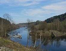
The municipality is bordered to the southwest by Grimstad, to the northwest by Froland, to the northeast by Tvedestrand, and to the southeast by the Skaggerak. The lake Rore is located on the Grimstad border along with the river Nidelva.
Arendal is the geologic type locality of the mineral Babingtonite, which was first described from specimens discovered here in 1824.[10]
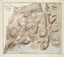
The coastal municipality includes several populated islands such as Hisøya, Tromøya, Merdø, Flostaøya, and Tverrdalsøya as well as many unpopulated or sparsely populated islands such as Ærøya. The island of Merdø was a major export port in the 17th and 18th centuries and now has a museum, a kiosk, and several beaches. There is regular boat service from Arendal to the island every day during the summer season.
Attractions
Townscape
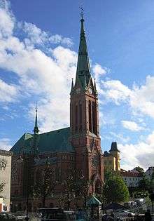
In the middle of the town centre of Arendal is an area with wooden houses dating back to the 17th century. This area is called Tyholmen, and is what is left of buildings from before the 19th century. The inner harbour of Arendal is called "Pollen", where the fish market, pubs, and restaurants are located. Trinity Church dominates the skyline of this area.
Arendal has grown from a traditional sleepy summer-town (with culture activities just in the summer) to a more "all year" city. The building of the new library and the combined city hall/concert house has greatly improved culture life.
Lighthouses
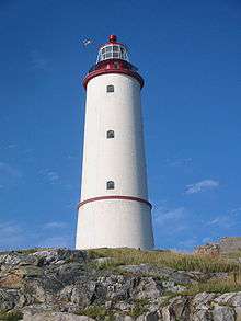
The Store Torungen Lighthouse is located on the island of Store Torungen outside Arendal. It was constructed in 1844 and electrified in 1914. It is 34.3 metres (113 ft) high and contains a 2nd order lens. It is reachable by a 55-minute boat trip from the town centre. The lighthouse is still in use.
The Lille Torungen Lighthouse is situated on the small island of Lille Torungen outside Arendal. The lighthouse is 28.9 metres (95 ft) high. Lille Torungen and Store Torungen were constructed as twin lighthouses, and both are located in the Arendal shipping lane.
The Sandvigodden Lighthouse is also located in Arendal.
Strømsbo gård
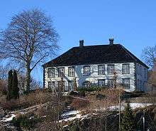
Strømsbo gård is a manor house on a historic farm located west of the center of Arendal. The manor dates from the 1760s. From 1804 the manor and farm were owned by members of the Herlofson family. Peter Herlofson took over the farm and gave the building its present form. In 1883, Axel Herlofsen (1845–1910) built the Strømsbo steam sawmill at the head of Strømsbubukt. Nicolai Benjamin Herlofson (1876-1945), former mayor of Arendal, was born and raised at Strømsbo.[11]
Music festivals
- Canal Street is Arendals yearly jazz and bluesfestival during the summer. It has been arranged since 1996, at that time by the name of Arendal Jazz and Blues Festival. The popularity of the arrangement has been steadily increasing.
- From 2007 until 2014, the Hove Festival was located on the island of Tromøy just outside Arendal town. It was the largest festival scene in Norway the debut year, and it has an audience capacity of up to 25,000.
Transport
The European route E18 highway is a major transportation route through Arendal heading to Oslo in the northeast and Kristiansand to the southwest. Other main roads in Arendal include the Norwegian County Road 407, Norwegian County Road 408, and Norwegian County Road 410. The local railway line Arendalsbanen runs to Nelaug where it connects with the main Sørlandsbanen railway line, which runs between the cities of Oslo and Stavanger.
The Setesdal Bilruter (on behalf of public transit authority AKT) provides bus connections throughout the Arendal area, the Setesdal-region including Froland, as well as to the neighboring towns of Grimstad, Lillesand and Kristiansand, and a handful of their suburbs and outlying villages. A few more destinations can be reached with other bus operators (namely Agder Buss, Nettbuss, Konkurrenten.no, and Lavprisekspressen), including places such as Risør, Tvedestrand, Oslo, and Stavanger.[12] There is also a bus connection to Kristiansand Airport operated by Agder Flyekspress and Nettbuss express (the latter on behalf of Flybussen.no).[13] Ferries run between the city center and the islands of Hisøya and Tromøya.[14][15] Arendal does also have an airport, Arendal Airport, Gullknapp, although it does not have any commercial airlines regularly stopping here.[16]
Climate
The climate here is mild, and generally warm and temperate. Arendal has a significant amount of rainfall during the year. This is true even for the driest month. The climate here is classified as Cfb by the Köppen-Geiger system. The average annual temperature in Arendal is 7.2 °C (45.0 °F). In a year, the average rainfall is 1,010 millimetres (40 in).
| Climate data for Arendal | |||||||||||||
|---|---|---|---|---|---|---|---|---|---|---|---|---|---|
| Month | Jan | Feb | Mar | Apr | May | Jun | Jul | Aug | Sep | Oct | Nov | Dec | Year |
| Average high °C (°F) | 1.8 (35.2) |
1.4 (34.5) |
3.4 (38.1) |
7.7 (45.9) |
13.0 (55.4) |
16.8 (62.2) |
19.2 (66.6) |
19.0 (66.2) |
15.3 (59.5) |
11.0 (51.8) |
6.7 (44.1) |
3.8 (38.8) |
9.9 (49.8) |
| Daily mean °C (°F) | −0.4 (31.3) |
−1.0 (30.2) |
0.9 (33.6) |
4.7 (40.5) |
9.6 (49.3) |
13.3 (55.9) |
15.9 (60.6) |
15.8 (60.4) |
12.5 (54.5) |
8.7 (47.7) |
4.5 (40.1) |
1.7 (35.1) |
7.2 (45) |
| Average low °C (°F) | −2.5 (27.5) |
−3.4 (25.9) |
−1.6 (29.1) |
1.7 (35.1) |
6.3 (43.3) |
9.9 (49.8) |
12.6 (54.7) |
12.6 (54.7) |
9.8 (49.6) |
6.4 (43.5) |
2.3 (36.1) |
−0.3 (31.5) |
4.5 (40.1) |
| Average precipitation mm (inches) | 85 (3.35) |
60 (2.36) |
67 (2.64) |
49 (1.93) |
61 (2.4) |
64 (2.52) |
78 (3.07) |
105 (4.13) |
107 (4.21) |
122 (4.8) |
120 (4.72) |
92 (3.62) |
1,010 (39.75) |
| Source: Climate-Data.org[17] | |||||||||||||
International relations
Twin towns — sister cities
Arendal has sister city agreements with the following places:[18]
In fiction
The 2013 Disney film Frozen is set in a fictional kingdom named Arendelle, which is derived from and loosely based on the city of Arendal.
Notable residents
- Sam Eyde (1866–1940), industrialist
- Øystein Grødum (1977), speedskater
- Finn Iunker (1969), playwright
- Karl Ove Knausgård (1968), writer
- Bård Torstensen (1961), Guitarist for heavy metal/rap band Clawfinger
- Jan Gunnar Solli (1981), football player and DJ
- Øyvind Sauvik (1976), Hip hop music
- Marit Fiane Christensen (1980), international footballer
- Ronald Frostestad, resident of San Francisco, California, respected health care consultant and manufacturer of Arendal audiophile speakers (d. 2016).
References
- ↑ "Navn på steder og personer: Innbyggjarnamn" (in Norwegian). Språkrådet. Retrieved 2015-12-01.
- 1 2 Thorsnæs, Geir, ed. (2017-06-21). "Arendal". Store norske leksikon (in Norwegian). Kunnskapsforlaget. Retrieved 2017-12-09.
- ↑ Statistisk sentralbyrå (2017). "Table: 06913: Population 1 January and population changes during the calendar year (M)" (in Norwegian). Retrieved 2017-12-09.
- 1 2 Jukvam, Dag (1999). "Historisk oversikt over endringer i kommune- og fylkesinndelingen" (PDF) (in Norwegian). Statistisk sentralbyrå.
- ↑ "Civic heraldry of Norway - Norske Kommunevåpen". Heraldry of the World. Retrieved 2017-12-09.
- ↑ "Byvåpenet" (in Norwegian). Arendal kommune. Retrieved 2017-12-09.
- ↑ Torstveit, Johannes G. (2012). "Storsvindel bankkrakk og nytt politisk parti 1886-88". Arendals Tidende (in Norwegian). Arendal.
- ↑ Frøstrup, Johan Christian (1998). Krigsår: Arendal under okkupasjonen 1940-1945 (in Norwegian). Arendal: Friluftsforl. p. 35. ISBN 8291495068.
- ↑ "Table: 04813: Members of the local councils, by party/electoral list at the Municipal Council election (M)" (in Norwegian). Statistics Norway. 2015.
- ↑ "Babingtonite". Mindat.org.
- ↑ "Strømsbo gård". kulturminnesok.no. Archived from the original on June 28, 2013. Retrieved February 5, 2016.
- ↑ "Arendalsområdet" (in Norwegian). AKT. Retrieved 2017-12-09.
- ↑ "Flybuss" (in Norwegian). AKT. Retrieved 2017-12-09.
- ↑ "Ferry Tromøy-Arendal-Hisøy". VisitNorway.com. Retrieved 2017-12-09.
- ↑ "Archived copy". Archived from the original on 2016-09-10. Retrieved 2013-06-27.
- ↑ "Arendal lufthavn Gullknapp" (in Norwegian). Retrieved 2017-12-09.
- ↑ "Climate: Arendal". Climate-Data.org. Retrieved 18 April 2014.
- ↑ "Vennskapsbyer" (in Norwegian). Arendal kommune. Archived from the original on 11 February 2009. Retrieved 2009-01-18.
- ↑ "Twin municipalities Norway-Iceland" (in Norwegian). Norwegian government. Retrieved 24 April 2012.
External links
| Wikimedia Commons has media related to Arendal. |
| Wikisource has the text of the 1911 Encyclopædia Britannica article Arendal. |
| Look up Arendal in Wiktionary, the free dictionary. |
- Municipal fact sheet from Statistics Norway (in Norwegian)

- Arendal official tourist information (in English)
- Arendal tourist information from Reiselivsbasen (in English)
- UNEP/GRID-Arendal, UN Environment Programme office in Arendal (in English)
- Arendal on Google Maps
- Map of Aust-Agder including Arendal municipality (in German)
- Municipality of Arendal (in Norwegian)
- Agderposten — The leading newspaper covering Aust-Agder, with base in Arendal (in Norwegian)
- County museum & archive: Aust-Agder kulturhistoriske center (in Norwegian)
- Webcam of Arendal centre (in Norwegian)
- Canal Street - Arendal Jazz and Blues festival (in Norwegian)
| Authority control |
|---|