Sibulan
| Sibulan | |
|---|---|
| Municipality | |
| Municipality of Sibulan | |
 Sibulan Public Plaza | |
 Map of Negros Oriental with Sibulan highlighted | |
.svg.png) Sibulan Location within the Philippines | |
| Coordinates: 9°21′N 123°17′E / 9.35°N 123.28°ECoordinates: 9°21′N 123°17′E / 9.35°N 123.28°E | |
| Country |
|
| Region | Central Visayas (Region VII) |
| Province | Negros Oriental |
| District | 2nd district of Negros Oriental |
| Barangays |
List
|
| Government [1] | |
| • Type | Sangguniang Bayan |
| • Mayor | Jose Abiera |
| • Vice Mayor | Marcela Bartoces |
| • Electorate | 27,774 voters (2016) |
| Area [2] | |
| • Total | 163.00 km2 (62.93 sq mi) |
| Population (2015 census)[3] | |
| • Total | 59,455 |
| • Density | 360/km2 (940/sq mi) |
| Time zone | UTC+8 (PST) |
| ZIP code | 6201 |
| PSGC | 074620000 |
| IDD : area code | +63 (0)35 |
| Climate type | Tropical climate |
| Income class | 2nd municipal income class |
| Revenue (₱) | 144,587,520.76 (2016) |
| Native languages |
Cebuano Tagalog |
| Website |
www |
Sibulan, officially the Municipality of Sibulan, (Cebuano: Lungsod sa Sibulan; Filipino: Bayan ng Sibulan), is a 2nd class municipality in the province of Negros Oriental, Philippines. According to the 2015 census, it has a population of 59,455 people.[3]
Sibulan is bordered to the south by the provincial capital of Dumaguete City. It is the location of the Dumaguete Airport, the main airport for Negros Oriental.
Sibulan is also the location of the Balinsasayao Twin Lakes Natural Park, composed of Lake Balinsasayao and Lake Danao. The site, managed by the provincial government, is located 1,047 metres (3,435 ft) above sea level on Mount Talinis.
Barangays
Sibulan is politically subdivided into 15 barangays.
- Agan-an
- Ajong
- Balugo
- Boloc-boloc
- Calabnugan
- Cangmating
- Enrique Villanueva
- Looc
- Magatas
- Maningcao
- Maslog
- Poblacion
- San Antonio
- Tubigon
- Tubtubon
Sibulan has six coastal barangays: from north to south they are Ajong, Looc, Poblacion, Cangmating, Maslog, Agan-an and Boloc-boloc. The provincial airport, known as the Dumaguete Airport, is actually in Agan-an, Sibulan. There is a growing number of guest houses and beach resorts from Cangmating southward to Dumaguete and the coral reefs of Ajong are attracting more dive boats.
The municipal seat is in barangay Poblacion, approximately midway along the coast of the town. The main municipal port facility is in Poblacion, where a fast ferry runs every hour to Santander on the tip of Cebu island. There is also a fishing and freight port in barangay Looc.
Sibulan has two small Marine Protected Areas (MPAs), which are coral reef areas that prohibit fishing, swimming and diving. One is in Agan-an, just north of the airport, the other is in Cangmating. These were established to improve the sustainability of the local fishery.
The inland barangays are primarily agricultural and residential with minimal business and public facilities. Most commercial development is along the national highway, which runs the length of the town from Dumaguete in the south to San Jose at the north. Most business and light industry is along the highway in Boloc-Boloc, Maslog, Agan-an and Poblacion. This is largely urban sprawl from Dumaguete seeking the advantageous tax rates in Sibulan.
Sibulan also boasts a golf course resort, perched on the foothills in barangay San Antonio, just north of the town center.
Demographics
| Population census of Sibulan | ||
|---|---|---|
| Year | Pop. | ±% p.a. |
| 1903 | 8,413 | — |
| 1918 | 9,833 | +1.05% |
| 1939 | 9,884 | +0.02% |
| 1948 | 8,096 | −2.19% |
| 1960 | 12,026 | +3.35% |
| 1970 | 16,861 | +3.43% |
| 1975 | 20,108 | +3.60% |
| 1980 | 23,123 | +2.83% |
| 1990 | 27,172 | +1.63% |
| 1995 | 31,206 | +2.63% |
| 2000 | 37,523 | +4.03% |
| 2007 | 47,162 | +3.20% |
| 2010 | 51,519 | +3.27% |
| 2015 | 59,455 | +2.77% |
| Source: Philippine Statistics Authority[3][4][5][6] | ||
Education
Public High Schools[7]
| Name | Location |
|---|---|
| Ajong National High School | North National Highway, Ajong Negros Oriental |
| Bolocboloc High School | Bolocboloc, Sibulan |
| Enrique Villanueva High School | Tubod, Enrique Villanueva Sibulan |
| Maningcao National High School | Maningcao, Sibulan |
| San Antonio National High School | San Antonio, Negros Oriental |
| Sibulan National High School | Osmena St., Poblacion |
| Sibulan NHS - Balugo Ext. | Balugo, Sibulan Negros Oriental |
| Sibulan National High School - Maslog Ext. | Maslog, Sibulan |
| Sibulan Science High School | Campaclan, Sibulan |
| Tubigon High School | Tubigon, Sibulan |
| Sibulan Night High School | Poblacion, Sibulan |
Elementary Schools[7]
- Bagtic Public School (Tubod)
- Balugo Elementary School
- Bolocboloc Elementary School
- Calabnugan Elementary School
- Calinawan Elementary School
- Cambajao Elementary School
- Cangmating Elementary School
- Cantalawan Elementary School
- Escaguit Elementary School
- Libertad Ong Calderon Memeorial ES (Ajong Elementary School)
- Lo-oc Elementary School
- Magatas Elementary School
- Magsaysay Memorial Elementary School
- Maningcao Elementary School
- Maslog Elementary School
- San Antonio Elementary School
- Sibulan Central Elementary School
- Tubigon Elementary School
- Tubtubon Elementary School
Gallery
 Municipal hall
 Bell-gabled Church
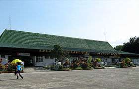
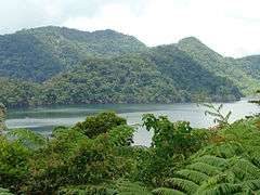 Lake Balinsasayao
References
- ↑ "Municipality". Quezon City, Philippines: Department of the Interior and Local Government. Retrieved 31 May 2013.
- ↑ "Province:". PSGC Interactive. Quezon City, Philippines: Philippine Statistics Authority. Retrieved 12 November 2016.
- 1 2 3 Census of Population (2015). "Region VII (Central Visayas)". Total Population by Province, City, Municipality and Barangay. PSA. Retrieved 20 June 2016.
- ↑ Census of Population and Housing (2010). "Region VII (Central Visayas)". Total Population by Province, City, Municipality and Barangay. NSO. Retrieved 29 June 2016.
- ↑ Censuses of Population (1903–2007). "Region VII (Central Visayas)". Table 1. Population Enumerated in Various Censuses by Province/Highly Urbanized City: 1903 to 2007. NSO.
- ↑ "Province of". Municipality Population Data. Local Water Utilities Administration Research Division. Retrieved 17 December 2016.
- 1 2 "dumaguete.com". Retrieved Sep 30, 2014.
External links
| Wikimedia Commons has media related to Sibulan, Negros Oriental. |
- The travel guide Wikivoyage includes Sibulan in its Dumaguete article.
- Philippine Standard Geographic Code
- Philippine Census Information
- Local Governance Performance Management System
Places adjacent to Sibulan | |
|---|---|