Kanlaon
| Kanlaon Volcano | |
|---|---|
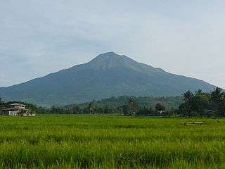 Kanlaon Volcano as seen from the east | |
| Highest point | |
| Elevation | 2,465 m (8,087 ft) |
| Prominence | 2,430 m (7,970 ft) |
| Listing | Ultra prominent peaks |
| Coordinates | 10°24′42″N 123°07′54″E / 10.41167°N 123.13167°ECoordinates: 10°24′42″N 123°07′54″E / 10.41167°N 123.13167°E |
| Geography | |
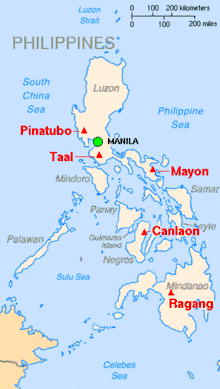
.svg.png) Kanlaon Volcano Map of the Philippines | |
| Country | Philippines |
| Region | |
| Provinces | |
| Geology | |
| Mountain type | Stratovolcano |
| Volcanic arc/belt | Negros Volcanic Belt |
| Last eruption | June 18, 2016 |
Kanlaon (Hiligaynon: Bulkan sang Kanlaon; Cebuano: Bulkan sa Kanlaon; Spanish: Volcán de Canlaon, Malaspina), also spelled as Kanla-on or sometimes Canlaon, is an active stratovolcano on the island of Negros, Philippines. It is the highest point in Negros, as well as the whole Visayas, with an elevation of 2,465 m (8,087 ft) above sea level.
The volcano straddles the provinces of Negros Occidental and Negros Oriental, approximately 30 km (19 mi) southeast of Bacolod, the capital and most populous city of Negros Occidental and of the whole island region. It is one of the active volcanoes in the Philippines and part of the Pacific Ring of Fire.
Physical features
Kanlaon has a peak elevation of 2,465 m (8,087 ft) at its highest point, although it is 2,435 m (7,989 ft) in some sources, with a base diameter of 30 km (19 mi) and is dotted with pyroclastic cones and extinct craters lining to the north-northwest. Just below and north of the summit is the active Lugud crater. North of Lugud is a 2 by 0.8 km (1.24 by 0.50 mi) caldera known as Margaja Valley, with a small, often seasonal crater lake.[1]
The volcano has three hot springs on its slopes: Mambukal Hot Springs on the northwest, Bucalan Hot Spring and Bungol Hot Spring. Its adjacent volcanic edifices are Mount Silay and Mount Mandalagan, north of Kanlaon.
Canlaon, the component city that has jurisdiction on the Negros Oriental side of the volcano, lies on its lower slope about 8.5 km (5.3 mi) ESE of the summit.[1]
Hiking Destination and Trails
The volcano is a favorite spot for mountain climbers and is the centerpiece of Mount Kanlaon Natural Park, a national park originally established on August 8, 1934.[2][3]
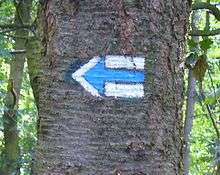
The hiking trails usually start in the center of the Guintubdan village. Locals have been active in international cooperation working with several European institutions to introduce the pioneering Unified Hiking Marker System as the first inland tourist location in the Philippines. The system is unified across a number of countries. This makes the mountain more attractive for tourists in an ecologically responsible way.
Trails & Hiking Markers System
In 2016, first three hiking trails have been marked, with additional and more extensive trails added in 2017 from the center of the Guintubdan village including a trail to the top. The works have been implemented by the Mendel University, in cooperation with De La Salle University Bacolod and DENR. The project has been financed by the Embassy of the Czech Republic in Manila in the framework of Czech Aid Development program [4]. Three color- coded trails using the colors of the Philippine flag were opened:
- Red Trail from Guintubdan to Buslugan Falls (marked in 2016)
- Yellow Trail from Guintubdan to Oro Falls (marked in 2016)
- Blue Trail from Guintubdan to Salas Park new Pavillion (marked in 2016)
- Red Trail from Guintubdan to Mt. Kanla-On Summit (marked in 2017)
- Adventure Trail and additional new trails (marked in 2017)
Hiking Markers Standard on Mt. Kanla-on

This system uses three bars - usually one color in between two white bars,[5] with different meanings attached to different colors: red indicates the most difficult or summit trails,[6] blue for difficult trails and yellow and green for easy or interconnecting trails. These marks may be posted on wooden boards or metallic plates.
Basic trail markers are square, 10x10 cm in size. The volunteers marking these trails usually prepare sheet metal or cardboard matrices to keep the signs uniform in size.
Any change of direction is marked with arrows of the same color and similar design.
Eruptions
The most active volcano in central Philippines, Kanlaon has erupted 30 times since 1819. Eruptions are typically phreatic of small-to-moderate size that produce minor ash falls around the volcano. In 1902, the eruption was classified as Strombolian, typified by the ejection of incandescent cinders, lapilli, lava bombs and gas fumes.[1] However, its eruptive history has not yet been recorded and larger Vesuvian eruptions generated by this stratovolcano hos not yet been known.
Volcanic activity at Kanlaon is continuously monitored by the Philippine Institute of Volcanology and Seismology (PHIVOLCS), the government's bureau that monitors the volcanoes and earthquakes in the nation, although unlike Mayon and Pinatubo, the volcano has never been studied in-depth and its age is not yet accurately calculated. Kanlaon Volcano Observatory is located at the campus of La Carlota City College in the barangay of Cubay, La Carlota City in Negros Occidental.[1]
1996 Kanlaon Incident
On August 10 of 1996, 24 mountain climbers hiked at the volcano when Kanlaon erupted without warning, killing British student Julian Green and Filipinos Jamrain Tragico and Neil Perez, who were trapped near the summit close to the crater. The local authorities rescued 17 others, including 10 Belgians, another British climber and six Filipinos while Edwin Ematong, a member of the Negros Mountaineering Club Inc. and who, along with his cousin Neil Perez, guided the British Nationals survived this eruption. He descended the volcano ahead of his group that fateful day.
One of the rescued Belgians, Caroline Verlinde, said she and her group were about to leave a site near the crater rim when suddenly the volcano ejected ash, stones and hot gas. She ran to a tree for cover and saw her friends being hit by falling hot tephra. She said their Filipino guide told them the smoke billowing out from the crater "was just ordinary."[7][8][9]
Recent volcanic activity
2001
PHIVOLCS noted in a 22 March report that since January 2001 earthquake clusters or occurrences have been recorded by the seismic monitoring network around the volcano. These earthquakes may signify a reactivation of the volcanic system at depth and could be a precursor to more vigorous activity, such as ash explosions. This interpretation is based on similar earthquake clusters manifested prior to the 10 August 1996 phreatic explosion from the active summit crater of the volcano. In view of the possibility of a sudden ash ejection, PHIVOLCS recommends the immediate suspension of all treks to the summit crater until further notice. As an additional precaution, the pre-defined 4-km-radius Permanent Danger Zone (PDZ) should be avoided at all times.
2002
An increase in seismic activity during February to April 2002 was followed by raising alert on the volcano. An ash eruption occurred on November 28, 2002.
2003
On March 17, 2003, a gray plume was observed above Kanlaon Volcano. Small eruptions produced plumes that rose 100 m above the crater of the volcano. A total of 46 minor ash ejections were recorded. After July 23, 2003, only weak emission was noted and seismic activity returned to normal.
2005
A brief phreatic ash eruption occurred at Canlaon volcano on 21 January 2005, producing a 500 m high ash plume. A fine layer of ash fell on the town of Cabagnaan 5.5 km SW of the crater. Ash emissions began again on 20 March and caused minor ash fall in the town of Guintubdan 5 km W of the volcano. Until 4 April, occasional ash eruptions reached 1 km above the volcano, and small ash fall was reported in the towns of La Castellana (16 km SW of the crater), Upper Sag-ang, Yubo (5–6 km SW), and Guintubdan (5–6 km WNW). Ash eruptions stopped after 25 May 2005.
2006
On June 3, 2006, Kanlaon again exhibited restiveness and spewed steam and ash. Alert Level 1 was issued on June 12, 2006. Until 25 July, a total of 23 ash eruptions were reported. All eruptions were phreatic (i.e. no fresh magma was ejected), and ejected ash and steam up to 2 km above the crater. No significant seismic activity had occurred before or after the ash emissions, indicating the explosions were near surface hydrothermal events.
2008
On February 10, 2008 PHIVOLCS issued an alert stating that the seismic network at Kanlaon Volcano recorded a total of 21 low frequency volcanic earthquakes (LFVQ) during the past 24 hours. Due to the increasing number of recorded volcanic earthquakes, PHIVOLCS raised Kanlaon Volcano’s alert status from Alert Level 0 to Alert Level 1, which means the volcano is at slightly elevated unrest and volcanic activity could lead to steam and ash ejections.[10] A 4-kilometre (2.5 mi) Permanent Danger Zone (PDZ) was maintained around the volcano, as sudden explosions may occur without warning, but no eruptions occurred.
2009
In the 8 days from August 23 to September 1, 257 volcanic earthquakes were recorded. Usual seismic activity during quiet periods is 0 to 4 quakes in any 24-hour period. Epicenters of the recorded quakes were clustered at the north-west slope which may indicate movement of an active local fault at the slope induced by pressure beneath the volcano. Surface observations did not show any significant change in the steam emission from the crater. PHIVOLCS maintained the alert status at Level 0.[11]
2015
On November 23, Kanlaon had a small, steam-driven explosion. PHIVOLCS raised the alert level to 1 (mild restiveness). On December 12, 2015, Kanlaon had two low energy ash eruption. The volcano is still in the state of unrest. The minor ash eruption of the volcano reached as high as 984 ft (300m). On December 27, 2015, an ash eruption occurred at Kanlaon's active crater. The eruption plume reached as high as 3281 ft (1000m). Light ashfall were reported in some barangays near Kanlaon Volcano.
On 2 January, people in Hinigaran got sick. Many suffered from a respiratory illness with cough and flu-like symptoms.
2016
In March 29 at 6:20 pm, Kanlaon erupted for 12 minutes which produced a volcanic plume 1500 meters above the crater and a "booming sound" was heard in some barangays near the volcano. According to the police department of Canlaon City, several fire balls, which were coming from the crater of the volcano, started to flow following a booming sound and causing a bush fire. PHIVOLCS issued alert level number 1. No casualties were reported.[12]
See also
References
- 1 2 3 4 "Kanlaon Volcano Page". Philippine Institute of Volcanology and Seismology.
- ↑ "NIPAS's 202 Initial list of components" Archived 2012-03-20 at the Wayback Machine.. Protected Areas and Wildlife Bureau. Retrieved on 2011-08-13.
- ↑ "Protected Areas of Region 6". Protected Areas and Wildlife Bureau. Retrieved on 2011-08-13.
- ↑ https://web.archive.org/web/20161220194818/http://www.eaglenews.ph/new-hiking-markers-in-negros-occidental/ New Hiking Markers in Negros Occidental
- ↑ "Czech Tourist Klub (KČT) | KLUB ČESKÝCH TURISTŮ". Kct.cz (in Czech). Retrieved 2017-03-25.
- ↑ "Hiking in the Czech Republic". Retrieved 25 November 2016.
- ↑ "Canlaon Volcano Eruption". aenet.org. Retrieved 13 December 2015.
- ↑ "Canlaon volcano eruptions". volcanodiscovery.com. VolcanoDiscovery Team. Retrieved 13 December 2015.
- ↑ The Kanlaon Volcano unrest, 10 August-14 October 1996. Philippine Institute of Volcanology and Seismology. Retrieved 13 December 2015.
- ↑ Phivolcs Kanlaon Update
- ↑ PHIVOLCS
- ↑ http://cnnphilippines.com/regional/2016/03/29/Negros-Oriental-Kanlaon-Volcano-erupts-Phivolcs.html
External links
| Wikimedia Commons has media related to Kanlaon (volcano). |