Xainza
- not to be confused with Naktsang Town in the Haa District of southwestern Bhutan
| Xainza | |
|---|---|
| Town | |
| Tibetan transcription(s) | |
| • Tibetan | ཤན་རྩ་རྫོང |
| • Wylie transliteration | shan rtsa rdzong |
| • official transcription (PRC) | Xainza |
| • THDL | Shentsa |
| Chinese transcription(s) | |
| • Traditional | 申扎镇 |
| • Simplified | 申扎县 |
| • Pinyin | Shēnzhā Xiàn |
 Xainza Location within Tibet | |
| Coordinates: 30°56′5″N 88°42′17″E / 30.93472°N 88.70472°E | |
| Country | China |
| Region | Tibet |
| Prefecture | Nagqu Prefecture |
| County | Xainza County |
| Area | |
| • Total | 2,146 km2 (829 sq mi) |
| Population (2004) | |
| • Total | 17,000 |
| • Major Nationalities | Tibetan |
| • Regional dialect | Tibetan language |
| Time zone | +8 |
Xainza (also Naktsang,[1] Xainza Town or Shantsa) is a town and township-level administrative unit and seat of Shentsa County or Xainza County, Nagqu Prefecture, Tibet Autonomous Region, China.
It covers an area of 2146 square kilometres and in 2004 had a total population of about 17,000.[2] The township was established by the Chinese in 1961.[3] The main occupation is animal husbandry, mainly yak, goat and sheep rearing.[3]
Villages
The township-level division contains the following settlements:[2]
- Gasangduo (neighborhood) (嘎桑多居委会)
- Rongsaiduo (neighborhood) (融塞多居委会)
- Nacha (拿查村)
- Luopu (罗普村 )
- Qiangrong (羌戎村)
- Qubu (曲布村)
- Yongzhu Woma (永珠沃玛村)
- Rennaduo (仁那多村)
Footnotes
References
- Dorje, Gyurme. Footprint Tibet Handbook. 4th Edition. (2009) Bath, U.K.
External links
| District | 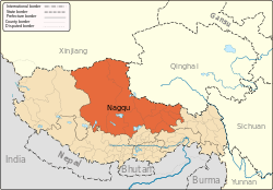 | |
|---|---|---|
| Counties | ||
| Towns and villages |
| |
| Geography |
| |
This article is issued from
Wikipedia.
The text is licensed under Creative Commons - Attribution - Sharealike.
Additional terms may apply for the media files.