Nagqu Town
| Nagqu 那曲镇 · ནག་ཆུ་གྲོང་རྡལ། | |
|---|---|
| Town | |
 Railway station | |
 Nagqu | |
| Coordinates: 31°29′N 92°03′E / 31.483°N 92.050°E | |
| Country | People's Republic of China |
| Autonomous region | Tibet Autonomous Region |
| Prefecture-level city | Nagqu |
| District | Seni |
| Elevation | 4,526 m (14,849 ft) |
| Time zone | UTC+8 (CST) |
Nagqu Town, Nagchu in original Tibetan or Naqu (Chinese: 那曲; pinyin: Nàqū), also known as Nagchuka or Nagquka, is a town in northern Tibet, seat of Nagqu, approximately 328 km (204 mi) by road north-east of the capital Lhasa, within the People's Republic of China.
Nagqu railway station to the town's west sits on the Qingzang railway at 4,526 m (14,849 ft). "Ngachu (...) is an important stop on both the road and railway line between Qīnghǎi and Tibet. In fact, this is where Hwy 317 ends as it joins the Qīnghǎi–Tibet Hwy (Hwy 109) on its way to Lhasa."[1]
At the time of the visit in 1950 of Thubten Jigme Norbu, the elder brother of Tenzin Gyatso the 14th Dalai Lama, Nagchukha was a small town with only a few clay huts but was also the headquarters of the District Officer, the Dzongpön. It was on the main caravan route coming from Amdo to Central Tibet.[2]
China is planning to build Nagqu Airport, the highest airport in the world at an altitude of 4,436 m (14,554 ft). The construction is planned to start in 2011 and expected to take three years to complete. When completed, it will overtake the current highest, Qamdo Bangda Airport, with an elevation of 4,334 m (14,219 ft).[3]
In 2015 Phayul reported that, "the local Tibetans of Nagshoe Township in Driru County were forced to abide by a four point imposition by the Chinese authorities who warned that failure to follow them would prohibit them to harvest the Yartsa Gunbo (Ophiocordyceps sinensis) for a period of five years. Tibetans in the area hugely depend for livelihood on the harvest of the fungus valued highly for its herbal remedy. The four point imposed by the Chinese authorities dictated the locals must have a ‘talent show’ where local Tibetans must perform songs and dances wearing costumes with wildlife pelts, a move to turn the Tibetans against an appeal by the exiled Tibetan leader to stop the use of animal products in costumes."[4]
With all months having a mean temperature below 10 °C, due to the town's very high altitude, Nagqu has an alpine climate (Köppen climate classification: EH), with long, very cold and dry winters, and short, cool summers.
| Climate data for Nagchu, Elevation = 4,505 m | |||||||||||||
|---|---|---|---|---|---|---|---|---|---|---|---|---|---|
| Month | Jan | Feb | Mar | Apr | May | Jun | Jul | Aug | Sep | Oct | Nov | Dec | Year |
| Average high °C (°F) | −2 (28) |
−1 (30) |
2 (36) |
6 (43) |
10 (50) |
14 (57) |
15 (59) |
14 (57) |
12 (54) |
7 (45) |
1 (34) |
−2 (28) |
6 (43) |
| Daily mean °C (°F) | −13 (9) |
−10 (14) |
−6 (21) |
−1 (30) |
3 (37) |
7 (45) |
9 (48) |
8 (46) |
5 (41) |
0 (32) |
−7 (19) |
−11 (12) |
−1 (30) |
| Average low °C (°F) | −22 (−8) |
−19 (−2) |
−14 (7) |
−9 (16) |
−3 (27) |
0 (32) |
3 (37) |
2 (36) |
0 (32) |
−6 (21) |
−15 (5) |
−21 (−6) |
−8 (18) |
| Average precipitation mm (inches) | 2 (0.08) |
2 (0.08) |
3 (0.12) |
10 (0.39) |
26 (1.02) |
82 (3.23) |
106 (4.17) |
94 (3.7) |
69 (2.72) |
20 (0.79) |
3 (0.12) |
3 (0.12) |
419 (16.5) |
| Source: weatherbase.com[5] | |||||||||||||
Footnotes
- ↑ Planet, Lonely. "Nagchu travel - Lonely Planet". Lonely Planet. Retrieved 2018-01-24.
- ↑ Tibet is My Country: Autobiography of Thubten Jigme Norbu, Brother of the Dalai Lama as told to Heinrich Harrer, p. 160. First published in German in 1960. English translation by Edward Fitzgerald, published 1960. Reprint, with updated new chapter, (1986): Wisdom Publications, London. ISBN 0-86171-045-2.
- ↑ "Tibet to be location of highest airport in the world." 12 Jan. 2010
- ↑ "Livelihood clampdown on Tibetans in Diru County". Phayul.com. Retrieved 2018-01-24.
- ↑ "Nagchu Climate Guide" - weatherbase.com
| District | 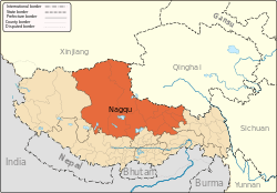 | |
|---|---|---|
| Counties | ||
| Towns and villages |
| |
| Geography |
| |