Gangnyi
| Gangnyi | |
|---|---|
| Township | |
 Gangnyi Location within Tibet | |
| Coordinates: 32°49′21″N 91°25′35″E / 32.82250°N 91.42639°ECoordinates: 32°49′21″N 91°25′35″E / 32.82250°N 91.42639°E | |
| Country | China |
| Region | Tibet |
| Prefecture | Nagqu Prefecture |
| County | Amdo County |
| Area | |
| • Total | 5,019 km2 (1,938 sq mi) |
| Population (2004) | |
| • Total | 1,300 |
| • Major Nationalities | Tibetan |
| • Regional dialect | Tibetan language |
| Time zone | +8 |
Gangnyi, Gangni, Gangnyixiang or Gangnixiang (Chinese: 岗尼乡) is a village and township-level division of Amdo County in the Nagqu Prefecture of the Tibet Autonomous Region, in China. It is located roughly 60 kilometres (37 mi) northwest of Amdo Town.[1] The township covers an area of 5,019 kilometres (3,119 mi) and as of 2004 it had a population of about 1300.[2] The principal economic activity is animal husbandry, pastoral yak, goat, sheep, and so on.[3]
Administrative divisions
The township-level division contains the following villages:[2]
- Longmu Village (隆木村)
- Dangguo Gangni Village (当果岗尼村)
- Nima Longmu Village 尼玛隆木村
- Nanacha Village (纳那查村)
- Domar Miri Gongou Village (多玛米日贡欧村)
- Duozhuo Jiajiang Village (多卓加江村)
See also
References
- ↑ Maps (Map). Google Maps.
- 1 2 "Gangnyi Township". CF Guide. Retrieved 29 May 2012.
- ↑ 岗尼乡 (in Chinese). Chinaquhua.cn. Retrieved 29 May 2012.
| District | 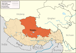 | |
|---|---|---|
| Counties | ||
| Towns and villages |
| |
| Geography |
| |
This article is issued from
Wikipedia.
The text is licensed under Creative Commons - Attribution - Sharealike.
Additional terms may apply for the media files.