Pana, Tibet
| Pana | |
|---|---|
| Town | |
 Pana Location within Tibet | |
| Coordinates: 32°15′45″N 91°40′42″E / 32.26250°N 91.67833°ECoordinates: 32°15′45″N 91°40′42″E / 32.26250°N 91.67833°E | |
| Country | China |
| Region | Tibet |
| Prefecture | Nagqu Prefecture |
| County | Amdo County |
| Population (2004) | |
| • Total | 2,700 |
| • Major Nationalities | Tibetan |
| • Regional dialect | Tibetan language |
| Time zone | +8 |
Pana, also Pagnag (Chinese: 帕那镇) is a small town and township-level division of Amdo County in the Nagqu Prefecture of the Tibet Autonomous Region, in China. It is located just outside Amdo Town.[1] As of 2004 it had a population of about 2700, 683 of which were living in the town of Pana.[2][3] The principal economic activity is animal husbandry, pastoral yak, goat, sheep, and so on.[3] Blueschist outcrops are found in the area. The villagers in recent times organized a railway protecting committee to select locals to monitor the Qinghai-Tibet Railway.[4]
Administrative divisions
The township-level division contains 42 villages and four village committees which are as follows:[2]
- Pana Neighborhood (帕纳居委会)
- Zhaliejin Village (扎烈金村)
- Turuo Village (土若村)
- Jiage Kagang Village (甲格卡岗村)
See also
References
- ↑ Maps (Map). Google Maps.
- 1 2 "Pana Town, Amdo". CF Guide. Retrieved 29 May 2012.
- 1 2 帕那镇 (in Chinese). Hudong Encyclopedia. Retrieved 29 May 2012.
- ↑ "Guarding Tibetan railway". Tibet Travel. Retrieved 29 May 2012.
| District | 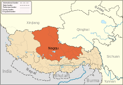 | |
|---|---|---|
| Counties | ||
| Towns and villages |
| |
| Geography |
| |
This article is issued from
Wikipedia.
The text is licensed under Creative Commons - Attribution - Sharealike.
Additional terms may apply for the media files.