Beartooth Highway
| |
|---|---|
 | |
| Route information | |
| Length | 68.7 mi[1] (110.6 km) |
| Major junctions | |
| West end |
|
| East end |
|
| Highway system | |
|
National Forest Scenic Byway | |
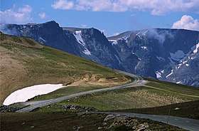 Approaching Beartooth Pass from the East along the Beartooth Highway | |
| Elevation | 10,947 ft (3,337 m) |
| Traversed by |
|
| Location | Montana / Wyoming, United States |
| Range | Beartooth Mountains |
| Coordinates | 44°58.1′N 109°27.9′W / 44.9683°N 109.4650°W |


The Beartooth Highway is an All-American Road on a section of U.S. Route 212 in Montana and Wyoming between Red Lodge and the Northeast entrance of Yellowstone National Park, passing over the Beartooth Pass in Wyoming at 10,947 feet (3,337 m) above sea level. It has been called "the most beautiful drive in America," by late CBS correspondent Charles Kuralt.[2] Because of heavy snowfall at the top, the pass is usually open each year only from mid May through mid October, weather conditions permitting.[3]
Route description
The Beartooth Highway is the section of U.S. Route 212 between Red Lodge, Montana and Cooke City, Montana. It traces a series of steep zigzags and switchbacks, along the Montana-Wyoming border to the 10,947 ft (3,337 m) high Beartooth Pass. The approximate elevation rise is from 5,200 ft (1,600 m) to 8,000 ft (2,400 m) in 12 mi (19 km) in the most daring landscapes.
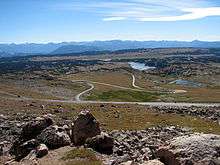
When driving east to west the highest parts of the Beartooth Highway level off into a wide plateau near the top of the pass, then descend to the junction with Wyoming Highway 296 (Chief Joseph Scenic Byway) near Cooke City, the northeast gateway to Yellowstone National Park. On the way one passes numerous lakes typical of the Absaroka-Beartooth Wilderness Area which borders the highway along much of its route.
The highway officially opened June 14, 1936.
Snowstorms can occur even in the middle of the summer at this altitude and the pass is also known for strong winds and severe thunderstorms. Drivers should plan on a driving time of at least two hours for the 69-mile (111 km) trip from Red Lodge to Cooke City. It is a good idea to check with the Red Lodge Chamber of Commerce or the Beartooth Ranger District beforehand in case of road closures.[3] Montana Traveler Information[4] and Wyoming Travel Information Service[5] both provide online information on Beartooth Highway travel conditions for their respective portions of the highway.
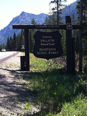
The Beartooth Highway passes through portions of Custer National Forest, and Shoshone National Forest and near the Absaroka-Beartooth Wilderness.
History
In August 1872, the pass was crossed by Civil War General Philip Sheridan and 120 men returning from an inspection tour of Yellowstone National Park. Rather than take the long detour down the Clarks Fork Yellowstone River to return to Billings, Sheridan took the advice of an old hunter named Shuki Greer, who claimed intimate knowledge of the Beartooth Mountains. When the road was opened in 1936, it essentially followed Sheridan's route over the pass.
2005 closure
Several large mudslides and rockslides on May 19-20, 2005 damaged or destroyed the Montana side of the Beartooth Highway in a dozen places between mile markers 39 and 51. The road was closed for reconstruction, and a $20.4 million construction contract issued which stipulated an October 2005 completion date. Construction was completed ahead of schedule however the highway never reopened for the year. An estimated 100,000 cubic yards (76,000 m3) of rock were removed from a 0.5-mile-long (0.80 km) section of the highway near the top of the switchbacks, and construction crews drilled down to solid bedrock to create new supports for the road.
References
- ↑ "Beartooth Highway". America's Byways. Federal Highway Administration. Retrieved August 18, 2015.
- ↑ Kulbacki, Michael; McCauley, Bert & Moler, Steve (July–August 2006). "An Orphaned Highway". Public Roads. Federal Highway Administration. Retrieved 2008-08-14.
- 1 2 Beartooth Highway Points of Interest, Red Lodge Montana Chamber of Commerce. Retrieved 2010-08-25.
- ↑ Montana Traveler Information, Retrieved 2010-08-25.
- ↑ Wyoming Travel Information Service, Retrieved 2010-08-25.
- Current Conditions
- Montana Scenic Byway: Beartooth Highway
- National Scenic Byways Project: Beartooth Highway, US Department of Transportation: National Scenic Highways Program.
External links
Route map:
| Wikimedia Commons has media related to Beartooth Highway. |
- Beartooth Highway website
- Historic American Engineering Record (HAER) No. WY-92, "Beartooth Highway, Red Lodge, Montana to Cooke City, Montana, Cody vicinity, Park County, WY"
- HAER No. WY-92-A, "Beartooth Highway, Beartooth Lake Bridge, Spanning Beartooth Lake outlet on U.S. Highway 212, Cody vicinity, Park County, WY"
- HAER No. WY-92-B, "Beartooth Highway, Little Bear Creek Bridge No. 1, Spanning Little Bear Creek on U.S. Highway 212 at Milepost 28.2, Cody vicinity, Park County, WY"
- HAER No. WY-92-C, "Beartooth Highway, Little Bear Creek Bridge No. 2, Spanning Little Bear Creek on U.S. Highway 212 at Milepost 29.0, Cody vicinity, Park County, WY"
- HAER No. WY-92-D, "Beartooth Highway, Long Lake Bridge, Spanning Long Lake outlet on U.S. Highway 212 at Milepost 31.2, Cody vicinity, Park County, WY"
Yellowstone National Park - Tower-Roosevelt and Lamar Valley | ||
|---|---|---|
Geography, historic structures and other attractions in the Tower Roosevelt and Lamar Valley areas | ||
| Structures and History |  | |
| Geography and Geology |
| |
| ||
