McLeod Glacier (South Orkney Islands)
| McLeod Glacier | |
|---|---|
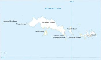 Location of McLeod Glacier in the South Orkney Islands | |
| Location | South Orkney Islands |
| Coordinates | 60°44′S 45°38′W / 60.733°S 45.633°W |
| Length | 1 nmi (2 km; 1 mi) |
| Thickness | unknown |
| Terminus | Clowes Bay |
| Status | unknown |
McLeod Glacier is a glacier 1 nautical mile (2 km) long, flowing in a southeasterly direction into Clowes Bay on the south side of Signy Island, in the South Orkney Islands off Antarctica. It was named by the UK Antarctic Place-Names Committee in 1954 for Michael McLeod, following a survey by the Falkland Islands Dependencies Survey in 1947. On December 12, 1821, the cutter Beaufoy under McLeod sailed to a position at least 60 nautical miles (110 km) west of the South Orkney Islands, where a chart annotation indicates that land was sighted, possibly Coronation Island.[1][2]
See also
References
- ↑ "McLeod Glacier". Geographic Names Information System. United States Geological Survey. Retrieved 2013-09-09.
- ↑ Alberts, Fred G., ed. (June 1995). Geographic Names of the Antarctic (PDF) (second ed.). United States Board on Geographic Names. p. 479. Retrieved 2012-04-05.
![]()
Coordinates: 60°44′S 45°38′W / 60.733°S 45.633°W