North Dakota Highway 3
| ||||
|---|---|---|---|---|
| Route information | ||||
| Maintained by NDDOT | ||||
| Length | 247.530 mi[1] (398.361 km) | |||
| Existed | 1939 – present | |||
| Major junctions | ||||
| South end |
| |||
| North end |
| |||
| Highway system | ||||
| ||||
.svg.png)
North Dakota Highway 3 (ND 3) is a 247.530-mile-long (398.361 km) major north–south state highway in the U.S. state of North Dakota. It travels from South Dakota Highway 45 (SD 45) at the South Dakota state line, south of Ashley north to Manitoba Highway 10 (PTH 10) at the International Peace Garden on the Canada–United States border.
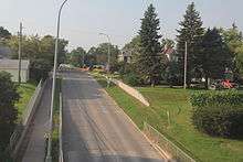
ND 3 in Rugby
Major intersections
| County | Location | mi[1] | km | Destinations | Notes |
|---|---|---|---|---|---|
| McIntosh | | 0.000 | 0.000 | Continuation into South Dakota | |
| Ashley | 6.810 | 10.960 | Eastern end of ND 11 concurrency | ||
| | 15.193 | 24.451 | Western end of ND 11 concurrency | ||
| Wishek | 31.974 | 51.457 | Eastern end of ND 13 concurrency | ||
| | 41.862 | 67.370 | Western end of ND 13 concurrency | ||
| Logan | Napoleon | 59.566 | 95.862 | ||
| Kidder | Sibley Township | 85.111 | 136.973 | Eastern end of I-94 concurrency; exit 208 | |
| Sibley–Woodlawn township line | 88.742 | 142.816 | Robinson | Exit 205 | |
| Woodlawn Township | 93.053 | 149.754 | Western end of I-94 concurrency; exit 200 | ||
| Clear Lake Township | 113.232 | 182.229 | |||
| Wells | Bull Moose Township | 134.277 | 216.098 | Western end of ND 200 concurrency | |
| Hurdsfield | 136.278 | 219.318 | Eastern end of ND 200 concurrency | ||
| Forward Township | 157.366 | 253.256 | Southern end of US 52 concurrency; southern terminus of US 52 Bus. | ||
| Hillsdale Township | 159.341 | 256.434 | Northern end of US 52 concurrency | ||
| 159.630 | 256.900 | ||||
| 159.863 | 257.275 | Short Spur to US 52 | |||
| Pierce | | 177.190 | 285.160 | ||
| Rugby | 201.386 | 324.099 | |||
| | 212.311 | 341.681 | Western terminus of ND 17; southern terminus of ND 60 | ||
| Rolette | Kohlmeier Township | 224.336 | 361.034 | Western terminus of ND 66 | |
| Dunseith | 233.548 | 375.859 | Eastern end of ND 5 concurrency; southern end of US 281 concurrency | ||
| 233.987 | 376.566 | Western end of ND 5 concurrency | |||
| | 244.140 | 392.905 | Eastern terminus of ND 43 | ||
| | 247.530 | 398.361 | Continuation into Manitoba; northern end of US 281 concurrency | ||
1.000 mi = 1.609 km; 1.000 km = 0.621 mi
| |||||
See also

References
- 1 2 Cartography Section, Planning/Asset Management Section (2015). Route and Mileage Map (PDF) (Map). c. 1:1,900,800. Bismarck: North Dakota Department of Transportation. Retrieved July 22, 2016.
External links
Route map:
- Geelhart, Chris. "Highways 1 to 30". The North Dakota Highways Page. Retrieved 2007-04-29.
This article is issued from
Wikipedia.
The text is licensed under Creative Commons - Attribution - Sharealike.
Additional terms may apply for the media files.