Maalaea, Hawaii
| Maalaea, Hawaii | |
|---|---|
| Census-designated place | |
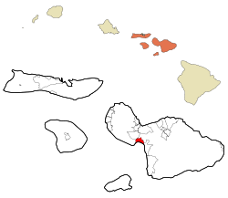 Location in Maui County and the state of Hawaii | |
| Coordinates: 20°48′34″N 156°29′27″W / 20.80944°N 156.49083°WCoordinates: 20°48′34″N 156°29′27″W / 20.80944°N 156.49083°W | |
| Country | United States |
| State | Hawaii |
| County | Maui |
| Area | |
| • Total | 7.8 sq mi (20.1 km2) |
| • Land | 5.4 sq mi (14.1 km2) |
| • Water | 2.3 sq mi (6.0 km2) |
| Elevation | 98 ft (30 m) |
| Population (2010) | |
| • Total | 352 |
| • Density | 45/sq mi (18/km2) |
| Time zone | UTC-10 (Hawaii-Aleutian) |
| Area code(s) | 808 |
| FIPS code | 15-46400 |
| GNIS feature ID | 0361945 |
Māʻalaea is a census-designated place (CDP) in Maui County, Hawaiʻi, United States. The population was 352 at the 2010 census.[1] Māʻalaea is the site of a small boat harbor, as well as the Maui Ocean Center.
Geography
Māʻalaea is located at 20°48′34″N 156°29′27″W / 20.80944°N 156.49083°W (20.809336, -156.490729).[2]
According to the United States Census Bureau, the CDP has a total area of 7.8 square miles (20.1 km2), of which 5.4 square miles (14.1 km2) is land and 2.3 square miles (6.0 km2), or 29.99%, is water.[3]
Demographics
As of the census of 2010, there were 352 people, 196 households, and 81 families residing in the CDP. The population density is 45 people per square mile (36.7/km²). The racial makeup of the CDP was 78.1% White, 2% African American, 0.3% Native American, 9.7% Asian, 5.4% Pacific Islander, 1.1% from other races, and 3.4% from two or more races. Hispanic or Latino of any race were 3.7% of the population.[4]
There were 196 households out of which 3.6% had children under the age of 18 living with them, 37.2% were married couples living together, 2.6% had a female householder with no husband present, and 58.7% were non-families. 51% of all households were single individuals and 42.3% had someone living alone who was 65 years of age or older. The average household size was 1.56 and the average family size was 2.15.[4]
In the CDP the population was spread out with 4.5% under the age of 18, 2.8% from 18 to 24, 15.3% from 25 to 44, 44.6% from 45 to 64, and 22.9% who were 65 years of age or older. The median age was 59 years. For every 100 females, there were 114 males. For every 100 females age 18 and over, there were 135 males.[5]
The median income for a household in the CDP was $73,083, and the median income for a family was $101,250. Males had a median income of $53,750 versus $72,708 for females. The per capita income for the CDP was $53,152. About 2.3% of families and 9.7% of the population were below the poverty line, including 16.7% of those under age 18 and 7.2% of those age 65 or over. [6]
Surfing
The wave called Māʻalaea, or freight train, is a right-hander off the breakwall and over a shallow coral reef. It is considered to be one of the world's fastest rideable waves, but is rideable only on large southerly swells.[7]
Gallery
 Maalaea "Coral Gardens" beach, looking north
 Maalaea "Coral Gardens" beach, looking south
 Maalaea "Coral Gardens" near Pali tunnel
Notes
- ↑ "Profile of General Population and Housing Characteristics: 2010 Demographic Profile Data (DP-1): Maalaea CDP, Hawaii". U.S. Census Bureau, American Factfinder. Retrieved December 29, 2011.
- ↑ "US Gazetteer files: 2010, 2000, and 1990". United States Census Bureau. 2011-02-12. Retrieved 2011-04-23.
- ↑ "Geographic Identifiers: 2010 Demographic Profile Data (DP-1): Maalaea CDP, Hawaii". U.S. Census Bureau, American Factfinder. Retrieved December 29, 2011.
- 1 2 Bureau, U.S. Census. "American FactFinder - Results". factfinder.census.gov. Retrieved 2018-05-21.
- ↑ Bureau, U.S. Census. "American FactFinder - Results". factfinder.census.gov. Retrieved 2018-05-21.
- ↑ Bureau, U.S. Census. "American FactFinder - Results". factfinder.census.gov. Retrieved 2018-05-21.
- ↑ "Maalaea Freight Trains Maui Surfing". World News. Retrieved 2018-05-21.
References
- Clark, John R. K. (1989), The Beaches of Maui County, University of Hawaii Press, pp. 50–51, ISBN 0-8248-1246-8
External links

- Maalaea Community Association web site.
Honolulu (capital) | ||
| Topics | ||
| Society | ||
| Main islands | ||
| Northwestern Islands | ||
| Communities | ||
| Counties | ||
| Sovereignty Movement | ||
Islands, municipalities, and communities of Maui County, Hawaii, United States | ||
|---|---|---|
| CDPs |  | |
| Unincorporated communities | ||
| Footnotes | ‡This populated place also has portions in an adjacent county or counties | |