Molokini
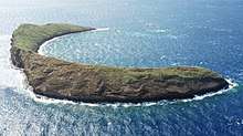
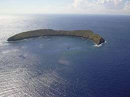 Aerial photo of Molokini | |
 Molokini  Molokini | |
| Geography | |
|---|---|
| Location | 20°38′00″N 156°29′46″W / 20.63333°N 156.49611°W[1] |
| Area | 23 acres (9.3 ha) |
| Highest elevation | 161 ft (49.1 m) |
| Administration | |
|
Hawaiʻi, United States | |
| Demographics | |
| Population | 0 |
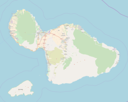
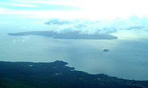
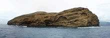
Molokini is a crescent-shaped, partially submerged volcanic crater which forms a small, uninhabited islet located in ʻAlalākeiki Channel between the islands of Maui and Kahoʻolawe, within Maui County in Hawaiʻi.
It is the remains of one of the seven Pleistocene epoch volcanoes that formed the prehistoric Maui Nui island, during the Quaternary Period of the Cenozoic Era.
The islet has an area of 23 acres (9.3 ha),[2] a diameter of about 0.4 miles (0.6 km), is 161 feet (50 m) at its highest point[3] and is located about 2.5 miles (4.0 km) west of Makena State Park and south of Maʻalaea Bay.
The islet is a Hawaiʻi State Seabird Sanctuary.
Recreation
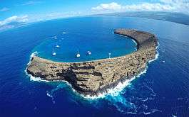
Molokini is a popular tourist destination for scuba diving, snuba, and snorkeling. Its crescent shape protects divers from waves and the channel's powerful currents. However, experienced scuba divers will also drift dive off the 300-foot (91.5-meter) sheer outer wall, using the channel currents to carry them along. In the morning, when winds are calmer, smaller tour boats can also bring guests to safely snorkel the backwall of Molokini[4] as well.
The crater houses a lush reef with excellent visibility as deep as 150 feet (46 m). Molokini is home to about 250 species of fish, many endemic (see Ecology below). The best conditions occur in early morning.[5] The water depth ranges from a single foot near the shore to 20–50 feet in the majority of the allowed dive spots.
Because Molokini attracts many boats, the Hawaii State Division of Boating and Recreation established mooring buoys and "Day Use Mooring Rules" for Molokini to protect against damage from dropped anchors. Its popularity has led many water-sport guides to lament that overcrowding has made the experience less attractive.
Mythology
In Hawaiian legend, Molokini was a beautiful woman. She and Pele, the fire goddess, were in love with the same man. The jealous Pele cut her rival in two and transformed her into stone. The woman's head is supposedly Puʻu Olai, the cinder cone by Makena Beach.
This is one of various legends involving Molokini Crater.
History
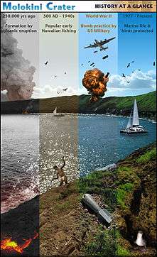
Potassium-argon dating by Yoshitomo Nishimitsu of Kyoto University indicates that Molokini erupted approximately 230,000 years ago.[6]
Archaeological evidence, primarily in the form of stone sinkers and lures, show that early Hawaiians visited Molokini to fish. They also likely harvested seabirds, eggs and feathers.[7]
During World War II, the United States Navy used Molokini for target practice, as its shape is somewhat similar to a battleship.[8] In 1975 and 1984, the Navy detonated in-place unexploded munitions found within the crater, resulting in the destruction of large areas of coral. This resulted in a public outcry. A thorough search and risky manual removal of unexploded munitions to deep water was carried out by volunteer divers as a result. As well, a 2006 survey found no evidence of unexploded munitions on the islet.[9] As a result of the extensive target practice, the southwest rim of the islet is fairly mutilated.
From the 1950s through the 1970s, commercial harvesting of black coral occurred in Molokini.[10]
In 1977 Molokini islet, the crater, and the surrounding 77 acres (31 ha) of underwater terrain were declared a Marine Life Conservation District (MLCD).[11]
Ecology
Molokini crater is home to approximately 250 to 260 marine species. Most commonly observed among these are the black triggerfish, yellow tang, Moorish idol, parrotfish, raccoon butterflyfish and bluefin trevally. Due to constant exposure to park visitors and the long history as a conservation district, the fish of Molokini are extremely comfortable with the presence of nearby divers. Small whitetip reef sharks and moray eels are occasionally seen in the crater. In addition, Red pencil urchins can be seen quite frequently.
The waters of Molokini contain 38 hard coral species and approximately 100 species of algae. Although quite dense on the seafloor, they are not as densely packed as they had historically been due to the constant tourism and activity there.
The islet is home to at least two species of nesting seabirds — Bulwer's petrels and wedge-tailed shearwaters. Additionally great frigatebirds have been observed on Molokini islet.[8]
Restrictions on access and activities
Molokini islet is federally owned and is a state seabird sanctuary. Thus, unauthorized landing is prohibited. Permission to land must be obtained both from the U.S. Coast Guard and the Hawaii Division of Forestry and Wildlife.[8]
Regulations covering the Molokini Shoal MLCD (see History above) prohibit fishing, collection or removal of specimens, and fish feeding within its bounds. Additionally, dropping anchor within the MLCD is not permitted due to the potential of damage to the coral reef. Tour boat operators have been allocated fixed mooring points instead.
Snorkeling and scuba diving is by far the most popular activity at the crater. Since the crater is made entirely of rock, the water remains relatively undisturbed by sand and sediment. Visibility at Molokini regularly exceeds 150 feet, and the inside of the crater is generally sheltered from strong winds and waves. The back wall of the island has been named one of the top 100 diving destination in the world according to scubadiving,com[12] This drift dive offers steep drop offs 360 feet to the ocean floor dramatic terrain, vibrant reef and unique underwater life.
References
- ↑ "Molokini". Geographic Names Information System. United States Geological Survey.
- ↑ "Molokini: Block 9000, Block Group 9, Census Tract 303.02, Maui County, Hawaii". United States Census Bureau.
- ↑ "CRAMP Study Sites: Molokini Island, Island of Maui". Coral Reef Assessment and Monitoring Program. University of Hawaii. Archived from the original on 2010-09-24. Retrieved 2010-11-28.
- ↑ "Snorkeling At Molokini". Retrieved September 5, 2014.
- ↑ "Hawaiiweb > Sites > Molokini". Archived from the original on January 2, 2002. Retrieved September 18, 2009.
- ↑ "USGS Hawaiian Volcano Observatory Update, Feb 8, 2001".
- ↑ "Molokini Crater History".
- 1 2 3 "Offshore Islet Restoration Committee".
- ↑ "Geology & History of Molokini".
- ↑ Severns, Mike; Fiene-Severns, Pauline (1993). Molokini Island: Hawaii's premier marine preserve. Pacific Islands Publishing, Inc. p. 19.
- ↑ "Maui - Molokini Shoal". Marine Life Conservation District. Hawaii Division of Aquatic Resources. Archived from the original on 2011-05-10. Retrieved 2011-03-27.
- ↑ "Top 100 Destination: Maui Diving". Scuba Diving. Retrieved 2018-02-06.
| Wikimedia Commons has media related to Molokini. |
Islands, municipalities, and communities of Maui County, Hawaii, United States | ||
|---|---|---|
| CDPs |  | |
| Unincorporated communities | ||
| Footnotes | ‡This populated place also has portions in an adjacent county or counties | |