English Bazar
| English Bazar | |
|---|---|
| Metropolitan City | |
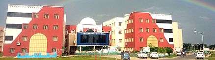
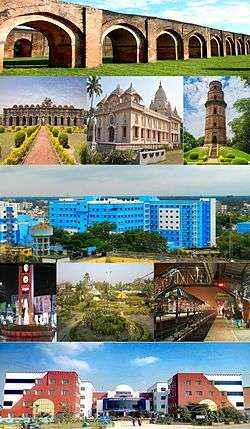 Malda city skyline, Adina Mosque, Gour, Ramkrishna Mission, Malada Medical College, Foara More, Park, University of Gour Banga | |
| Nickname(s): Mango City/ Gateway of North Bengal | |
 English Bazar Location in West Bengal, India  English Bazar English Bazar (India) | |
| Coordinates: 25°01′N 88°08′E / 25.01°N 88.14°ECoordinates: 25°01′N 88°08′E / 25.01°N 88.14°E | |
| Country |
|
| State | West Bengal |
| District | Malda |
| Division | Malda |
| Railway Station | Malda Town |
| No. of Wards | 29 |
| Government | |
| • Type | Civic Administration |
| • Body | English Bazar Municipality |
| • Chairman | Nihar Ranjan Ghosh |
| Area | |
| • Metropolitan City | 81 km2 (31 sq mi) |
| Elevation | 17 m (56 ft) |
| Population (2017)[1] | |
| • Metropolitan City | 600,000 |
| • Rank | 4th in West Bengal |
| • Density | 7,400/km2 (19,000/sq mi) |
| • Metro[2] | 600,000 |
| Demonym(s) | Maldabasi |
| Languages | |
| • Official | Bengali, English |
| Time zone | UTC+5:30 (IST) |
| PIN | 732101, 732102, 732103, 732141, 732142, 732128 |
| Telephone code | 91-3512-2xxxxx |
| Vehicle registration | WB-65/WB-66 |
| Lok Sabha constituency | Maldaha Dakshin |
| Vidhan Sabha constituency | Old Malda |
| River | Mahananda River |
| Website |
www |
| 1The coordinates given here are metric and based upon the Microsoft Encarta Reference Library Map Center 2005. | |
English Bazar or Ingraj Bazar, better known as Malda, the "Mango City", is a city in Malda district in the Indian state of West Bengal. It serves as the district headquarters. It is the fourth largest city in West Bengal.[3] Malda is a municipal corporation with two municipalities, English Bazar municipality and Old Malda municipality. This is a Undeveloped City becoming bigger since 1925-1930 and the city is rapidly growing and its population had now cross over a half of million people. English Bazar is the divisional headquarters of Malda Division in this state.
Geography
Malda is at 25°00′39″N 88°08′28″E / 25.0108°N 88.1411°E[4] It has an average elevation of 17 metres (56 feet). It is on the western bank of the river Mahananda.
As in much of Bengal, the weather is usually extremely humid and tropical. Temperatures can reach as high as 46 °C during the day in May and June and fall as low as 4 °C overnight in December and January.
History
The district of Malda formed in 1813 out of the outlying areas of Purnia, Dinajpur, and Rajshahi districts. In 1832 a separate treasury was established, and in 1859 a magistrate and collector were appointed.
Up to 1876 this district formed part of Rajshahi Division, and from 1876 to 1905 it formed part of Bhagalpur Division. In 1905, it was again transferred to Rajshahi Division, and until 1947 Malda remained in this division.
In August 1947 this district was affected by the Partition of India. Between 12 and 15 August 1947 whether the district would become part of India or Pakistan was unknown, as the announcement of the Radcliffe Line did not make this point clear. During these few days the district was under a magistrate of East Pakistan; after the details of the Radcliffe award were published, the district became part of West Bengal on 17 August 1947.
Civic administration
There are two municipalities in Malda. The English Bazar Municipality and the municipality of Old Malda.
The municipality of English Bazar is divided into 29 wards. The Trinamool Congress with 15 councillors holds power (as of 2015).
Metropolitan area
The metropolitan area of English bazar consist of Mangalbari, Old Malda(M), Chatianmore, Sahapur(CT), Bagbari(CT), Narayanpur,Jodupur Heart of the city is Rathbari (The gateway of Malda District) It is the most busiest Business Centre.
Transport
Road
NH 12 crosses through the heart of the city. The Gour Kanya Bus Terminus serves as bus depot for both Private Buses and Government Bus Service which is operated by the NBSCT (North Bengal State Transport Corporation). It is connected to all the other districts and cities in West Bengal like Siliguri, East Midnapur, Bankura, Purulia, Burdwan, Kalna, Ranaghat, Kalyani, Barackpore, Digha, Bolpur, Rampurhat, Durgapur, Asansol, Siuri, Cochbehar Mathabhanga and Berhampore. Lots of private buses connect the local short and long distance routes, including Nalagola, Bululbi, Aiho, Pakua, Gazole, Manikchak, Kaliachak, Sujapur, Samsi, Farakka, Chanchal, Gangarampur, Balurghat, Baharampur, Raiganj and Siliguri.
E-rickshaws (TOTO) are mostly available in the city to cover short distance. There are also private cars and taxis, Maxi, Tata Magic and Maximo Presents for local transportation.
Rail
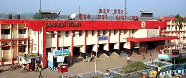
There are four railway stations which serves the metropolitan city. These are Malda Town Railway Station which serves the English Bazar area. Second one is Old Malda Railway Station which serves the Old Malda area.The third one is Malda Court Railway Station which serves the Mangalbari and Naldubi area and Gour Malda Railway Station which serves the Mohhadipur and Gauḍa (city) area. Malda's main railway station is Malda Town. It is a busy station and all trains stop here. According to Indian Railway, Malda Town is in the top 100 ticket booking stations all over India. It is the Divisional Headquarters of Eastern Railway's Malda Division; about 70% of this division is in Bihar and Jharkhand. Financial department officials have offices there. Almost all trains bound for North Bengal and the north eastern states of India pass through Malda Town station.
Lots of Express and mail trains depart from this station. Howrah-NJP Line passes through this station.
Most top class trains Like Shatabdi Express stop in this station. Mega cities like Delhi, Mumbai, Kolkata, Chennai, Bangalore Lucknow, Surat, Patna, Hyderabad, Tiruvanathapuram, Bhubaneshwar, Ranchi, Raipur, Guwahati and Agartala all are well connected through the rail route. Howrah-Njp Shatabdi Express which is cover the fastest train in this region.
Air
Malda Airport (IATA: LDA, ICAO: VEMH) was closed in 1972 due to the Bangladesh War. Before that there were direct daily flights from Malda to Kolkata, Delhi, and Guwahati. In 2014 direct helicopter services were started between Malda and Kolkata, the capital of West Bengal, by the government of West Bengal. As of 2017 the airport is under construction and the flight service will start very soon.
Demographics
As of the 2011 census, English Bazar municipality had a population of 216,083[1] and the metropolitan city had a population of 324,237.[5] The municipality had a sex ratio of 877 females per 1,000 males and 14.9% of the population were under six years old.[1] Effective literacy was 84.69%; male literacy was 85.44% and female literacy was 83.86%.[1]
Hotels& resorts
There are lots of hotels and resorts in Malda. The Golden Park hotel and resort located at Narayanpur is the best in malda with helipad. Some other hotels are Hotel Kalinga, Hotel Purvanchal, Hotel pratapaditya, Hotel Landmark, Hotel Samrat, Hotel Hari Om, Hotel Silver Arcade, Hotel Parvat, Hotel Mango leaf, Hotel MMC, Motel Pother Sathi etc.A Water Park for enjoyment Aquatic Bengal at Narayanpur is also best in the city.
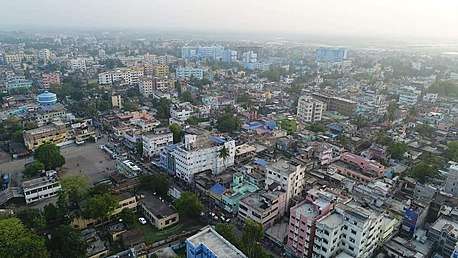
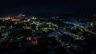
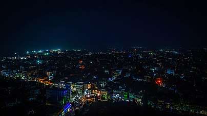
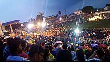
Malda City Skyline
Education
Colleges and universities
Several colleges and universities are in and around English Bazar. The largest is the University of Gour Banga, established in 2008. Almost all the 28 colleges in Malda, Uttar Dinajpur and Dakshin Dinajpur districts, except for Raiganj University College, are affiliated with it.
Other notable institutions include Malda College, established on 23 July 1944, the oldest higher educational institution in the city; and Malda Women's College, the only women's college in the city. English Bazar has three engineering colleges:Ghani Khan Choudhury Institute of Engineering & Technology established in 2010 is a Centrally Funded Technical Institute under Ministry of Human Resource Development Government of India; IMPS College of Engineering and Technology, established in 2003; and Malda Polytechnic, one of the oldest and best polytechnic colleges in West Bengal
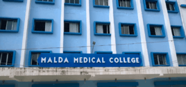
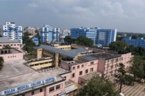
Malda Medical College and Hospital is the only medical college.
Universities
General degree Colleges
- Malda College
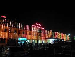 Malda Town Railway Station at night
 - Malda Women's College
Engineering colleges
- Ghani Khan Choudhury Institute of Engineering & Technology (GKCIET)
- IMPS College of Engineering and Technology
ITI colleges
- ITI Malda
- Malda Polytechnic
Medical colleges
Boys' high schools
- A. C. Institution
- Badalmoni High School
- Bibhuti Bhusan High School
- Lalit Mohan Shyam Mohini High School
- Maheshmati Dhirendranath Saha Vidyabhaban
- Malanchapally High School
- Malda Bibhuti Bhushan High School
- Malda Town High School
- Malda Umesh Chandra Bastuhara Vidyalaya
- Malda Zilla School
- Ramakrishna Mission Vivekananda Vidyamandir
- UCB High School
Girls' high schools
- Barlow Girls' High School
- Chintamani Chamatkar Girls' High School
- Jalalia Girls' High School
- Kanya Sikshalaya
- Malda Girls High School
- Nivedita Girls High School
- Ramkinkar Balika Vidyashram
- Thakur Anukul Chandra Girls High School
Hindi language schools
- J M S Hindi High School
Muslim schools
- Al Ameen Mission Academy
- Malda Model Madrasa
- Malda English Medium Madrasa
- Tarbiyah Cambridge International School
Rail schools
Primary schools
- Jingle Bell School
- Naalanda Shishu Shikhaniketan
- Park Ghat Prathomik Bidyalay
- Pathshala Prathomik Vidyalay
- Sabuj Abujh Shishu Angan
English medium schools
- Daffodils English Academy
- Holy Child English Academy
- North Point English Academy
- Swami Vivekananda Academy
- The St. Xavier's School
- Usha Martin School, Malda
- Delhi Public World School
- St. Mary's school
Kendriya Vidyalaya
- Kendriya Vidyalaya, Malda
- Kendriya Vidyalaya, Aradhpur (Near BSF Camp)
Pre-School
- Kidzee
Hospitals and health care
Malda is becoming the medical hub of this region. Malda Medical College and Hospital is a top class hospital in the district and also nearby district. There are lots of primary healthcare centers in the city. Private nursing homes, a pathology centre, clinics, and medical stores are present.

Malda Medical College and Hospital
The Government of West Bengal decided to set up a new medical college at the strategically located district of Malda, which is easily accessible to the districts in the region of North Bengal.
Malda Railway Hospital
Malda Railway Hospital is established to serve health care for railway needs. It is situated near the Malda Town Railway Station.
Private hospitals and nursing homes

Lots of private hospitals and nursing homes like Sonoscan; Dishari Health Care Point; Malda Medical Centre; Mangalbari Nursing Home; Mullick Nursing Home are available in the city. A top class private pathology care center is also available.
Media And Newspapers
All national channels and also some local media channels like High TV, Sabar Cable, Sabar Monoranjan, MCN News, CCN and DAM's TV are local channels which are operated throughout the city. And also serves nearby districts news like North Dinajpur, South Dinajpur, and Murshidabad
Newspapers
- Aamader Malda
- Guide Malda
- Rupantare Pathe
- Uttarbanga Sangbad
Sports facilities
There are lots of indoor and outdoor stadiums. Satya Choudhury Indoor Stadium has games like table tennis, badminton, and judo. District Sports Association Stadium is used for outdoor games like cricket. A swimming pool is also available for swimming competitions. Laxman Sen Outdoor Stadium is another outdoor stadium. Brindabani Maidan which is situated in the middle of the city is an outdoor stadium with a large capacity. All school sports and local and state level cricket and football matches are playing in this ground.Hussein Sah Indoor stadium is an Indoor Railway Stadium.
Notable people
See also
References
- 1 2 3 4 "Provisional Population Totals, Census of India 2011; Cities having population 1 lakh and above" (pdf). Office of the Registrar General & Census Commissioner, India. Retrieved 27 March 2012.
- ↑ http://censusindia.gov.in/2011-prov-results/paper2/data_files/India2/Table_2_PR_Cities_1Lakh_and_Above.pdf
- ↑ "Urban Agglomerations/Cities having population 1 lakh and above" (PDF). Provisional Population Totals, Census of India 2011. Retrieved 10 October 2011.
- ↑ "Maps, Weather, and Airports for Ingraj Bazar, India". fallingrain.com.
- ↑ "Provisional Population Totals, Census of India 2011; Urban Agglomerations/Cities having population 1 lakh and above" (pdf). Office of the Registrar General & Census Commissioner, India. Retrieved 27 March 2012.
Further reading
- Chakrabarti D.K. (1992). Notes on the archaeology of Maldaha and West Dinajpur districts, West Bengal. South Asian Studies, 9:pp. 123–135
External links
![]()
Cities, towns and locations in Malda district | |||||
|---|---|---|---|---|---|
| Cities, municipal and census towns |
| ||||
| Locations other than cities and towns | |||||
| Related topics |
| ||||