Radcliffe Line
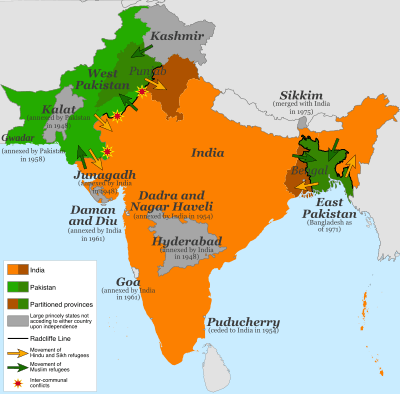
The Radcliffe Line was the boundary demarcation line between the Indian and Pakistani portions of the Punjab and Bengal provinces of British India. It was named after its architect, Sir Cyril Radcliffe, who, as the joint chairman of the two boundary commissions for the two provinces, received the responsibility to equitably divide 175,000 square miles (450,000 km2) of territory with 88 million people.[1]
The demarcation line was published on 17 August 1947 upon the Partition of India. Today its western side still serves as the Indo-Pakistani border and the eastern side serves as the India-Bangladesh border.
Background
Events leading up to the Radcliffe Boundary Commissions
On 15 July 1947, the Indian Independence Act 1947 of the Parliament of the United Kingdom stipulated that British rule in India would come to an end just one month later, on 15 August 1947. The Act also stipulated the partition of the Presidencies and provinces of British India into two new sovereign dominions: the Union of India and the Dominion of Pakistan.
The Indian Independence Act, passed by the British parliament, abandoned the suzerainty of the British Crown over the princely states and dissolved the Indian Empire, and the rulers of the states were advised to accede to one of the new dominions.[2]
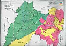
Pakistan was intended as a Muslim homeland, while the Union of India remained secular. Muslim-majority British provinces in the north were to become the foundation of Pakistan. The provinces of Baluchistan (91.8% Muslim before partition) and Sindh (72.7%) were granted entirely to Pakistan. However, two provinces did not have an overwhelming majority—Bengal in the north-east (54.4% Muslim) and the Punjab in the north-west (55.7% Muslim).[3] The western part of the Punjab became part of West Pakistan and the eastern part became the Indian state of East Punjab, which was later divided between a smaller Punjab State and two other states. Bengal was also partitioned, into East Bengal (in Pakistan) and West Bengal (in India). Following independence, the North-West Frontier Province (whose borders with Afghanistan had earlier been demarcated by the Durand Line) voted in a referendum to join Pakistan.[4] This controversial referendum was boycotted by the most popular Pukhtun movement in the province at that time. The area is now a province in Pakistan called Khyber Pakhtunkhwa.
The Punjab's population distribution was such that there was no line that could neatly divide Hindus, Muslims, and Sikhs. Likewise, no line could appease the Muslim League, headed by Jinnah, and the Indian National Congress led by Jawaharlal Nehru and Vallabhbhai Patel, and by the British. Moreover, any division based on religious communities was sure to entail "cutting through road and rail communications, irrigation schemes, electric power systems and even individual landholdings."[5] However, a well-drawn line could minimize the separation of farmers from their fields, and also minimize the numbers of people who might feel forced to relocate.
As it turned out, on "the sub-continent as a whole, some 14 million people left their homes and set out by every means possible—by air, train, and road, in cars and lorries, in buses and bullock carts, but most of all on foot—to seek refuge with their own kind."[6] Many of them were slaughtered by an opposing side, some starved or died of exhaustion, while others were afflicted with "cholera, dysentery, and all those other diseases that afflict undernourished refugees everywhere".[7] Estimates of the number of people who died range between 200,000 (official British estimate at the time) and two million, with the consensus being around one million dead.[7]
Prior ideas of partition
The idea of partitioning the provinces of Bengal and Punjab had been present since the beginning of the 20th century. Bengal had in fact been partitioned by the then viceroy Lord Curzon in 1905, along with its adjoining regions. The resulting 'Eastern Bengal and Assam' province, with its capital at Dhaka, had a Muslim majority and the 'West Bengal' province, with its capital at Calcutta, had a Hindu majority. However, this partition of Bengal was reversed in 1911 in an effort to mollify Bengali nationalism.[8]
Proposals for partitioning Punjab had been made starting from 1908. Its proponents included the Hindu leader Bhai Parmanand, Congress leader Lala Lajpat Rai, industrialist G. D. Birla, and various Sikh leaders. After the Lahore resolution (1940) of the Muslim League demanding Pakistan, B. R. Ambedkar wrote a 400-page tract titled Thoughts on Pakistan,[9] wherein he discussed the boundaries of the Muslim and non-Muslim regions of Punjab and Bengal. His calculations showed a Muslim majority in 16 western districts of Punjab and non-Muslim majority in 13 eastern districts. In Bengal, he showed non-Muslim majority in 15 districts. He thought the Muslims could have no objection to redrawing provincial boundaries. If they did, "they [did] not understand the nature of their own demand".[10][11]
After the breakdown of the 1945 Simla Conference of viceroy Lord Wavell, the idea of Pakistan began to be contemplated seriously. Sir Evan Jenkins, the private secretary of the viceroy (later the governor of Punjab), wrote a memorandum titled "Pakistan and the Punjab", where he discussed the issues surrounding the partition of Punjab. K. M. Panikkar, then prime minister of the Bikaner State, sent a memorandum to the viceroy titled "Next Step in India", wherein he recommended that the British government concede the principle of 'Muslim homeland' but carry out territorial adjustments to the Punjab and Bengal to meet the claims of the Hindus and Sikhs. Based on these discussions, the viceroy sent a note on "Pakistan theory" to the Secretary of State.[12] The viceroy informed the Secretary of State that Jinnah envisaged full provinces of Bengal and Punjab going to Pakistan with only minor adjustments, whereas Congress was expecting almost half of these provinces to remain in India. This essentially framed the problem of partition.[13]
The Secretary of State responded by directing Lord Wavell to send 'actual proposals for defining genuine Muslim areas'. The task fell on V. P. Menon, the Reforms Commissioner, and his colleague Sir B. N. Rau in the Reforms Office. They prepared a note called "Demarcation of Pakistan Areas", where they defined the western zone of Pakistan as consisting of Sindh, N.W.F.P., British Baluchistan and three western divisions of Punjab (Rawalpindi, Multan and Lahore). However, they noted that this allocation would leave 2.2 million Sikhs in the Pakistan area and about 1.5 million in India. Excluding the Amritsar and Gurdaspur districts of the Lahore Division from Pakistan would put a majority of Sikhs in India. (Amritsar had a non-Muslim majority and Gurdaspur a marginal Muslim majority.) To compensate for the exclusion of the Gurdaspur district, they included the entire Dinajpur district in the eastern zone of Pakistan, which similarly had a marginal Muslim majority. After receiving comments from John Thorne, member of the Executive Council in charge of Home affairs, Wavell forwarded the proposal to the Secretary of State. He justified the exclusion of the Amritsar district because of its sacredness to the Sikhs and that of Gurdaspur district because it had to go with Amritsar for 'geographical reasons'.[14][15][lower-alpha 1] The Secretary of State commended the proposal and forwarded it to the India and Burma Committee, saying, "I do not think that any better division than the one the Viceroy proposes is likely to be found".[16]
Sikh concerns
While Master Tara Singh confused Rajagopalchari's offer with the Muslim League demand he could see that any division of Punjab would leave the Sikhs divided between Pakistan and Hindustan. He espoused the doctrine of self-reliance, opposed partition and called for independence on the grounds that no single religious community should control Punjab. Other Sikhs argued that just as Muslims feared Hindu domination the Sikhs also feared Muslim domination. Sikhs warned the British government that the morale of Sikh troops in the British Army would be affected if Pakistan was forced on them. Since Hindus seemed more concerned about the rest of India than Punjab, Master Tara Singh refused to ally with them and preferred to approach the British directly. Giani Kartar Singh drafted the scheme of a separate Sikh state if India was divided.[17]
During the Partition developments Jinnah offered Sikhs to live in Pakistan with safeguards for their rights. Sikhs refused because they opposed the concept of Pakistan and also because they were opposed to being a small minority within a Muslim majority. There are various reasons for the Sikh refusal to join Pakistan but one clear fact was that the Partition of Punjab left a deep impact on the Sikh psyche with many Sikh holy sites ending up in Pakistan.[18]
While the Congress had insisted for an India which was united and the Muslim League asked for a separate country, Sikh leader Dr. Vir Singh Bhatti proposed the creation of a separate Sikh state "Khalistan".[19] Sikh leaders who were unanimous in their opposition to Pakistan wanted a Sikh state to be created. Master Tara Singh wanted the right for an independent Khalistan to federate with either Hindustan or Pakistan. However, the Sikh state being proposed was for an area where no religion was in absolute majority.[20] Negotiations for the independent Sikh state had commenced at the end of World War II and the British initially agreed but the Sikhs withdrew this demand after pressure from Indian nationalists.[21] The proposals of the Cabinet Mission Plan had seriously jolted the Sikhs because while both the Congress and League could be satisfied the Sikhs saw nothing in it for themselves. as they would be subjected to a Muslim majority. Master Tara Singh protested this to Pethic-Lawrence on May 5. By early September the Sikh leaders accepted both the long term and interim proposals despite their earlier rejection.[20] The Sikhs attached themselves to the Indian state with the promise of religious and cultural autonomy.[21]
Final negotiations
In March 1946, the British government sent a Cabinet Mission to India to find a solution to resolve the conflicting demands of Congress and the Muslim League. Congress agreed to allow Pakistan to be formed with 'genuine Muslim areas'. The Sikh leaders asked for a Sikh state with Ambala, Jalandher, Lahore Divisions with some districts from the Multan Division, which, however, did not meet the Cabinet delegates' agreement. In discussions with Jinnah, the Cabinet Mission offered either a 'smaller Pakistan' with all the Muslim-majority districts except Gurdaspur or a 'larger Pakistan' under the sovereignty of the Indian Union.[22] The Cabinet Mission came close to success with its proposal for an Indian Union under a federal scheme, but it fell apart in the end because of Nehru's opposition to a heavily decentralised India.[23][24]
Hindus and Sikhs in Punjab and Bengal clamoured for the division of these two provinces, arguing that if India could be divided along religious lines then so should these provinces because the Muslim majorities in both provinces were small.[25] The British agreed.[26][27] Scholar Akbar Ahmed says that the basic unit of administration in India was the province and not the district and that the district level division reduced the principle of partition to absurdity. According to Ahmed, such a division should have meant that Muslim estates in the United Provinces be separated and given to Pakistan.[28]
Scholar Sialkoti writes that V.P Menon decided with Sardar Patel to only give Muslims a ″moth-eaten Pakistan.″ Nehru then discussed partitioning Punjab and Bengal with Wavell. Nehru told Menon that the partition of Punjab and Bengal would bring the more fertile parts of these two provinces into the Indian Union so that a truncated Pakistan would not be worth having. [25] Nehru told Gandhi that ″it is unlikely that Jinnah and the Muslim League will agree to this truncated Pakistan which can never succeed economically or otherwise.″ Sir Cripps remarked ″the Pakistan they are likely to get would be very different from what they wanted and it may not be worth their while.″[29] On March 8 the Congress passed a resolution to divide Punjab.[29][30]
In March 1947, Lord Mountbatten arrived in India as the next viceroy, with an explicit mandate to achieve transfer of power before June 1948. Scholar Sialkoti states that Mountbatten and his staff had already evaluated all the recommendations for the partition of Punjab and done their homework prior to their arrival. Within ten days, Mountbatten's staff had categorically stated that Congress had conceded the Pakistan demand except for the 13 eastern districts of Punjab (including Amritsar and Gurdaspur).[31]
However, Jinnah held out. Through a series of six meetings with Mountbatten, he continued to maintain that his demand was for six full provinces. He "bitterly complained" that the Viceroy was ruining his Pakistan by cutting Punjab and Bengal in half as this would mean a 'moth-eaten Pakistan'.[32][33][34]
The Gurdaspur district remained a key contentious issue for the non-Muslims. Their members of the Punjab legislature made representations to Mountbatten's chief of staff Lord Ismay as well as the Governor telling them that Gurdaspur was a "non-Muslim district". They contended that even if it had a marginal Muslim majority of 51%, which they believed to be erroneous, the Muslims paid only 35% of the land revenue in the district.[35]
In April, Governor Evan Jenkins wrote a note to Mountbatten proposing that Punjab be divided along Muslim and non-Muslim majority districts, but "adjustments could be made by agreement" regarding the tehsils (subdistricts) contiguous to these districts. He proposed that a Boundary Commission be set up consisting of two Muslim and two non-Muslim members recommended by the Punjab Legislative Assembly. He also proposed that a British judge of the High Court be appointed as the chairman of the Commission.[36] Jinnah and the Muslim League continued to oppose the idea of partitioning the provinces, and the Sikhs were disturbed about the possibility of getting only 12 districts (without Gurdaspur). In this context the Partition Plan of 3 June was announced with a notional partition showing 17 districts of Punjab in Pakistan and 12 districts in India, along with the establishment of a Boundary Commission to decide the final boundary. In Sialkoti's view, this was done mainly to placate the Sikhs.[37]
Mountbatten decided to threaten Jinnah by drawing a line less favourable to Muslims and more favourable to Sikhs if he did not agree to partitioning Punjab and Bengal.[38] However, Lord Ismay prevailed that he should use 'hurt feelings' rather than threats to persuade Jinnah for partition. They ultimately succeeded.[39] On the 2nd of June Jinnah once again approached Mountbatten to plead for the unity of Punjab and Bengal but Mountbatten threatened that ' 'You will lose Pakistan probably for good.' '[28]
Process and key people
A crude border had already been drawn up by Lord Wavell, the Viceroy of India prior to his replacement as Viceroy, in February 1947, by Lord Louis Mountbatten. In order to determine exactly which territories to assign to each country, in June 1947, Britain appointed Sir Cyril Radcliffe to chair two Boundary Commissions—one for Bengal and one for Punjab.[40]
The Commission was instructed to "demarcate the boundaries of the two parts of the Punjab on the basis of ascertaining the contiguous majority areas of Muslims and non-Muslims. In doing so, it will also take into account other factors."[41] Other factors were undefined, giving Radcliffe leeway, but included decisions regarding "natural boundaries, communications, watercourses and irrigation systems", as well as socio-political consideration.[42] Each commission also had 4 representatives—2 from the Indian National Congress and 2 from the Muslim League. Given the deadlock between the interests of the two sides and their rancorous relationship, the final decision was essentially Radcliffe's.
After arriving in India on 8 July 1947, Radcliffe was given just five weeks to decide on a border.[40] He soon met with his fellow college alumnus Mountbatten and travelled to Lahore and Calcutta to meet with commission members, chiefly Nehru from the Congress and Jinnah, president of the Muslim League.[43] He objected to the short time frame, but all parties were insistent that the line be finished by the 15 August British withdrawal from India. Mountbatten had accepted the post as Viceroy on the condition of an early deadline.[44] The decision was completed just a couple of days before the withdrawal, but due to political manoeuvring, not published until 17 August 1947, two days after the grant of independence to India and Pakistan.[40]
Members of the Commissions
Each boundary commission consisted of 5 people – a chairman (Radcliffe), 2 members nominated by the Indian National Congress and 2 members nominated by the Muslim League.[45]
The Bengal Boundary Commission consisted of Justices C. C. Biswas, B. K. Mukherji, Abu Saleh Mohamed Akram and S.A.Rahman.[46]
The members of the Punjab Commission were Justices Mehr Chand Mahajan, Teja Singh, Din Mohamed and Muhammad Munir.[46]
Problems in the process
Boundary-making procedures
All lawyers by trade, Radcliffe and the other commissioners had all of the polish and none of the specialized knowledge needed for the task. They had no advisers to inform them of the well-established procedures and information needed to draw a boundary. Nor was there time to gather the survey and regional information. The absence of some experts and advisers, such as the United Nations, was deliberate, to avoid delay.[47] Britain's new Labour government "deep in wartime debt, simply couldn’t afford to hold on to its increasingly unstable empire."[48] "The absence of outside participants—for example, from the United Nations—also satisfied the British Government's urgent desire to save face by avoiding the appearance that it required outside help to govern—or stop governing—its own empire."[49]
Political representation
The equal representation given to politicians from Indian National Congress and the Muslim League appeared to provide balance, but instead created deadlock. The relationships were so tendentious that the judges "could hardly bear to speak to each other", and the agendas so at odds that there seemed to be little point anyway. Even worse, "the wife and two children of the Sikh judge in Lahore had been murdered by Muslims in Rawalpindi a few weeks earlier."[50]
In fact, minimizing the numbers of Hindus and Muslims on the wrong side of the line was not the only concern to balance. The Punjab Border Commission was to draw a border through the middle of an area home to the Sikh community.[51] Lord Islay was rueful for the British not to give more consideration to the community who, in his words, had "provided many thousands of splendid recruits for the Indian Army" in its service for the crown in World War I.[52] However, the Sikhs were militant in their opposition to any solution which would put their community in a Muslim ruled state. Moreover, many insisted on their own sovereign state, something no-one else would agree to.[53]
Last of all, were the communities without any representation. The Bengal Border Commission representatives were chiefly concerned with the question of who would get Calcutta. The Buddhist tribes in the Chittagong Hill Tracts in Bengal had no official representation and were left totally without information to prepare for their situation until two days after the partition.[54]
Perceiving the situation as intractable and urgent, Radcliffe went on to make all the difficult decisions himself. This was impossible from inception, but Radcliffe seems to have had no doubt in himself and raised no official complaint or proposal to change the circumstances.[1]
Local knowledge
Before his appointment, Radcliffe had never visited India and knew no one there. To the British and the feuding politicians alike, this neutrality was looked upon as an asset; he was considered to be unbiased toward any of the parties, except of course Britain.[1] Only his private secretary, Christopher Beaumont, was familiar with the administration and life in the Punjab. Wanting to preserve the appearance of impartiality, Radcliffe also kept his distance from Viceroy Mountbatten.[5]
No amount of knowledge could produce a line that would completely avoid conflict; already, "sectarian riots in Punjab and Bengal dimmed hopes for a quick and dignified British withdrawal".[55] "Many of the seeds of postcolonial disorder in South Asia were sown much earlier, in a century and half of direct and indirect British control of large part of the region, but, as book after book has demonstrated, nothing in the complex tragedy of partition was inevitable."[56]
Haste and indifference
Radcliffe justified the casual division with the truism that no matter what he did, people would suffer. The thinking behind this justification may never be known since Radcliffe "destroyed all his papers before he left India".[57] He departed on Independence Day itself, before even the boundary awards were distributed. By his own admission, Radcliffe was heavily influenced by his lack of fitness for the Indian climate and his eagerness to depart India.[58]
The implementation was no less hasty than the process of drawing the border. On 16 August 1947 at 5:00 pm, the Indian and Pakistani representatives were given two hours to study copies, before the Radcliffe award was published on 17 August.[59]
Secrecy
To avoid disputes and delays, the division was done in secret. The final Awards were ready on 9 August and 12 August, but not published until two days after the partition.
According to Read and Fisher, there is some circumstantial evidence that Nehru and Patel were secretly informed of the Punjab Award's contents on August 9 or 10, either through Mountbatten or Radcliffe's Indian assistant secretary.[60] Regardless of how it transpired, the award was changed to put a salient east of the Sutlej canal within India's domain instead of Pakistan's. This area consisted of two Muslim-majority tehsils with a combined population of over half a million. There were two apparent reasons for the switch: the area housed an army arms depot, and contained the headwaters of a canal which irrigated the princely state of Bikaner, which would accede to India.
Implementation
After the partition, the fledgling governments of India and Pakistan were left with all responsibility to implement the border. After visiting Lahore in August, Viceroy Mountbatten hastily arranged a Punjab Boundary Force to keep the peace around Lahore, but 50,000 men was not enough to prevent thousands of killings, 77% of which were in the rural areas. Given the size of the territory, the force amounted to less than one soldier per square mile. This was not enough to protect the cities much less the caravans of the hundreds of thousands of refugees who were fleeing their homes in what would become Pakistan.[61]
Both India and Pakistan were loath to violate the agreement by supporting the rebellions of villages drawn on the wrong side of the border, as this could prompt a loss of face on the international stage and require the British or the UN to intervene. Border conflicts led to three wars, in 1947, 1965, and 1971, and the Kargil conflict of 1999.
Disputes along the Radcliffe Line
There were disputes regarding the Radcliffe Line's award of the Chittagong Hill Tracts and the Gurdaspur district. Disputes also evolved around the districts of Malda, Khulna, and Murshidabad in Bengal and the sub-division of Karimganj of Assam.
In addition to Gurdaspur's Muslim majority tehsils, Radcliffe also gave the Muslim majority tehsils of Ajnala (Amritsar District), Zira, Ferozpur (in Ferozpur District), Nakodar and Jullander (in Jullander District) to India instead of Pakistan.[62]
Punjab
Ferozpur District
Indian historians now accept that Mountbatten probably did influence the Ferozpur award in India's favour.[63]
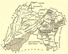
Gurdaspur District
Under British control, the Gurdaspur district was the northernmost district of the Punjab Province. The district itself was administratively subdivided into four tehsils: Shakargarh and Pathankot tehsils to the north, and Gurdaspur and Batala tehsils to the south. Of the four, only the Shakargarh tehsil, which was separated from the rest of the district by the Ravi river, was awarded to Pakistan. (It was subsequently merged into the Narowal district of West Punjab.[64]) The Gurdaspur, Batala and Pathankot tehsils became part of India's East Punjab state. The division of the district was followed by a population transfer between the two nations, with Muslims leaving for Pakistan and Hindus and Sikhs leaving for India.
The entire district of Gurdaspur had a bare majority of 50.2% Muslims.[65] (In the `notional' award attached to the Indian Independence Act, all of Gurdaspur district was marked as Pakistan with 51.14% Muslim majority.[66] In the 1901 census, the population of Gurdaspur district was 49% Muslim, 40% Hindu, and 10% Sikh.[67]) The Pathankot tehsil was predominantly Hindu while the other three tehsils were Muslim majority.[68] In the event, only Shakargarh was awarded to Pakistan.
Radcliffe explained that the reason for deviating from the notional award in case of Gurdaspur was that the headwaters of the canals that irrigated the Amritsar district lay in the Gurdaspur district and it was important to keep them under one administration.[66] Lord Wavell had stated in February 1946 that Gurdaspur had to go with the Amritsar district, and the latter could not be in Pakistan due to its Sikh religious shrines.[66] In addition, the railway line from Amritsar to Pathankot passed through the Batala and Gurdaspur tehsils.[69]
Pakistanis have alleged that the award of the three tehsils to India was a manipulation of the Award by Lord Mountbatten in an effort to provide a land route for India to Jammu and Kashmir.[65] However, Shereen Ilahi points out that the land route to Kashmir was entirely within the Pathankot tehsil, which had a Hindu majority. The award of the Batala and Gurdaspur tehsils to India did not affect Kashmir.[70]
Pakistani View on the Award of Gurdaspur to India
Pakistan maintains that the Radcliffe Award was altered by Mountbatten; Gurdaspur was handed over to India and thus was manipulated the accession of Kashmir to India.[71] As per the `notional' award that had already been put into effect for purposes of administration ad interim, all of Gurdaspur district, owing to its Muslim majority, was assigned to Pakistan.[72] From August 14th to 17th, Mushtaq Ahmed Cheema acted as the Deputy Commissioner of the Gurdaspur District, but when, after a delay of two days, it was announced that the major portion of the district had been awarded to India instead of Pakistan, Cheema left for Pakistan.[73] The major part of Gurdaspur district, i.e. three of the four sub-districts and a small part of the fourth, had been handed over to India giving India practical land access to Kashmir, thus making the Indian intervention in Kashmir possible.[74] It came as a great blow to Pakistan. Jinnah and other leaders of Pakistan, and particularly its officials, criticized the Award as ‘extremely unjust and unfair’.[75]
Muhammad Zafarullah Khan, who represented the Muslim League in July 1947 before the Radcliffe Boundary Commission, stated that the Boundary Commission was a farce. A secret deal between Mountbatten and Congress leaders had already been struck.[76] Mehr Chand Mahajan, one of the two Non Muslim members of the Boundary Commission, in his autobiography, has acknowledged that when he was selected for the boundary commission, he was not inclined to accept the invitation as he believed that the commission was just a farce and that decisions were actually to be taken by Mountbatten himself.[77] It was only under British pressure that the charges against Mountbatten of last minute alterations in the Radcliffe Award were not officially brought forward by Pakistani Government in the UN Security Council while presenting its case on Kashmir.[78]
Zafrullah Khan states that, in actual fact, adopting the tehsil as a unit would have given Pakistan the Ferozepur and Zira tehsils of the Ferozpur District, the Jullundur and Rahon tehsils of Jullundur district and the Dasuya tehsil of the Hoshiarpur district. The line so drawn would also give Pakistan the State of Kapurthala (which had a Muslim majority) and would enclose within Pakistan the whole of the Amritsar district of which only one tehsil, Ajnala, had a Muslim majority. It would also give Pakistan the Shakargarh, Batala and Gurdaspur tehsils of the Gurdaspur district. If the boundary went by Doabs, Pakistan could get not only the 16 districts which had already under the notional partition been put into West Punjab, including the Gurdaspur District, but also get the Kangra District in the mountains, to the north and east of Gurdaspur. Or one could go by Commissioners' divisions. Any of these units being adopted would have been more favourable to Pakistan than the present boundary line. The tehsil was the most favourable unit.[72] But all of the aforementioned Muslim majority tehsils, with the exception of Shakargarh, were handed over to India while Pakistan didn't receive any Non-Muslim majority district or tehsil in Punjab.[62] Zafruallh Khan states that Radcliffe used district, tehsil, thana, and even village boundaries to divide Punjab in such a way that the boundary line was drawn much to the prejudice of Pakistan.[72]
According to Zafrullah Khan, the assertion that the award of the Batala and Gurdaspur tehsils to India did not 'affect' Kashmir is far-fetched. If Batala and Gurdaspur had gone to Pakistan, Pathankot tehsil would have been isolated and blocked. Even though it would have been possible for India to get access to Pathankot through the Hoshiarpur district, it would have taken quite long time to construct the roads, bridges and communications that would have been necessary for military movements.[74]
Assessments on the 'Controversial Award of Gurdaspur to India and the Kashmir Dispute'
Stanley Wolpert writes that Radcliffe in his initial maps awarded Gurdaspur district to Pakistan but one of Nehru’s and Mountbatten’s greatest concerns over the new Punjab border was to make sure that Gurdaspur would not go to Pakistan, since that would have deprived India of direct road access to Kashmir.[79] As per "The Different Aspects of Islamic Culture", a part of UNESCO’s Histories flagship project, recently disclosed documents of the history of the partition reveal British complicity with the top Indian leadership to wrest Kashmir from Pakistan. Alastair Lamb, based on the study of recently declassified documents, has convincingly proven that Mountbatten, in league with Nehru, was instrumental in pressurizing Radcliffe to award the Muslim-majority district of Gurdaspur in East Punjab to India which could provide India with the only possible access to Kashmir.[80] Andrew Roberts believes that Mountbatten cheated over India-Pak frontier[81] and states that if gerrymandering took place in the case of Ferozepur, it is not too hard to believe that Mountbatten also pressurized Radcliffe to ensure that Gurdaspur wound up in India to give India road access to Kashmir.[82][83][84]
Perry Anderson states that Mountbatten, who was officially supposed to neither exercise any influence on Radcliffe nor to have any knowledge of his findings, intervened behind the scenes – probably at Nehru’s behest – to alter the award. He had little difficulty in getting Radcliffe to change his boundaries to allot the Muslim-majority district of Gurdaspur to India instead of Pakistan, thus giving India the only road access from Delhi to Kashmir.[85]
However, some British works suggest that the 'Kashmir State was not in anybody's mind'[86] when the Award was being drawn and that even the Pakistanis themselves had not realized the importance of Gurdaspur to Kashmir until the Indian forces actually entered Kashmir.[87] Both Mountbatten and Radcliffe, of course, have strongly denied those charges. It is impossible to accurately quantify the personal responsibility for the tragedy of Kashmir as the Mountbatten papers relating to the issue at the India Office Library and records are closed to scholars for an indefinite period.[88]
Bengal
Chittagong Hill Tracts
Chittagong Hill Tracts had a majority non-Muslim population of 97% (most of them Buddhists), but was given to Pakistan. The Chittagong Hill Tracts People's Association (CHTPA) petitioned the Bengal Boundary Commission that, since the CHTs were inhabited largely by non-Muslims, they should remain within India. Since they had no official representation, there was no official discussion on the matter, and many on the Indian side assumed the CHT would be awarded to India.
On 15 August 1947, many of the tribes did not know to which side of the border they belonged. On 17 August, the publication of the Radcliffe Award put the CHTs in Pakistan. The rationale of giving the Chittagong Hill Tracts to Pakistan was that they were inaccessible to India and to provide a substantial rural buffer to support Chittagong (now in Bangladesh), a major city and port; advocates for Pakistan forcefully argued to the Bengal Boundary Commission that the only approach was through Chittagong.
Two days later, the CHTPA resolved not to abide by the award and hoisted the Indian flag. The Pakistani army dealt with the protest but its polemic somewhat remains with some of its non-Muslim majority arguing for its secession.[89]
Malda District
Another disputed decision made by Radcliffe was division of the Malda district of Bengal. The district overall had a slight Muslim majority, but was divided and most of it, including Malda town, went to India. The district remained under East Pakistan administration for 3–4 days after 15 August 1947. It was only when the award was made public that the Pakistani flag was replaced by the Indian flag in Malda.
Khulna and Murshidabad Districts
The entire Khulna District with a marginal Hindu majority of 51% was also given to East Pakistan in lieu of a smaller Murshidabad district with a 70% Muslim majority, which went to India.
Karimganj
Sylhet district of Assam joined Pakistan in accordance with a referendum.[90] However, the Karimganj sub-division with a Muslim majority was severed from Sylhet and given to India. As of the 2001 Indian Census, Karimganj now has a Muslim majority of 52.3%.
Legacy
Legacy and historiography
The Partition of India is one of the central events in the collective memory in India, Pakistan, and Bangladesh. On his motivation to write Drawing the Line, playwright Howard Brenton said he first became interested in the story of the Radcliffe Line while vacationing in India and hearing stories from people whose families had fled across the new line.[91]
Artistic depictions
As a crucial determiner in the outcomes of the partition, the Radcliffe Line and award process has been referred to in many films, books, and other artistic depictions of the partition of India. The specific commemoration of the award or the recounting of the story of the process and the people involved in it has been comparatively rare.
One notable depiction is Drawing the Line, written by British playwright Howard Brenton. Defending his portrayal of Cyril Radcliffe as a man who struggled with his conscience, Brenton said, "There were clues that Radcliffe had a dark night of the soul in the bungalow: he refused to accept his fee, he did collect all the papers and draft maps, took them home to England and burnt them. And he refused to say a word, even to his family, about what happened. My playwright's brain went into overdrive when I discovered these details."[91]
Indian filmmaker Ram Madhvani created a nine-minute short film where he explored the plausible scenario of Radcliffe regretting the line he drew. The film was inspired by WH Auden’s poem on the Partition.[92][93]
See also
Notes
- ↑ Schofield, Kashmir in Conflict (2003, p. 35): Wavell, however, had made a more significant political judgement in his plan, submitted to the secretary of state, Lord Pethick-Lawrence, in February 1946: 'Gurdaspur must go with Amritsar for geographical reasons and Amritsar being sacred city of Sikhs must stay out of Pakistan... Fact that much of Lahore district is irrigated from upper Bari Doab canal with headworks in Gurdaspur district is awkward but there is no solution that avoids all such difficulties.'
References
- 1 2 3 Read & Fisher, The Proudest Day 1998, p. 482
- ↑ Ishtiaq Ahmed, State, Nation and Ethnicity in Contemporary South Asia (London & New York, 1998), p. 99: "On 15 August 1947 India achieved independence... The several hundred princely states which came within Indian territory could in principle remain independent but were advised by both the British government and the Congress Party to join India."
- ↑ Smitha, Independence section, para. 7.
- ↑ See North-West Frontier Province and "North-West Frontier Province" Archived 4 June 2011 at the Wayback Machine. from the Columbia Encyclopedia, Sixth Edition, 2008, at Encyclopedia.com, accessed 10 September 2009
- 1 2 Read & Fisher, The Proudest Day 1998, p. 483
- ↑ Read & Fisher, The Proudest Day 1998, p. 497: "Ten million of them were in the central Punjab. In an area measuring about 200 miles (320 km) by 150 miles (240 km), roughly the size of Scotland, with some 17,000 towns and villages, five million Muslims were trekking from east to west, and five million Hindus and Sikhs trekking in the opposite direction. Many of them never made it to their destinations."
- 1 2 Read & Fisher, The Proudest Day 1998, p. 499
- ↑ Tan & Kudaisya 2000, p. 162–163.
- ↑ Ambedkar, Bhimrao Ramji (1941) [first published 1940], Thoughts on Pakistan, Bombay: Thacker and company
- ↑ Sialkoti, Punjab Boundary Line Issue 2014, p. 73–76.
- ↑ Dhulipala, Creating a New Medina 2015, pp. 124, 134, 142–144, 149: "Thoughts on Pakistan 'rocked Indian politics for a decade'."
- ↑ Sialkoti, Punjab Boundary Line Issue 2014, p. 82.
- ↑ Sialkoti, Punjab Boundary Line Issue 2014, p. 84–85.
- ↑ Sialkoti, Punjab Boundary Line Issue 2014, p. 85–86.
- ↑ Datta, The Punjab Boundary Commission Award 1998, p. 858.
- ↑ Sialkoti, Punjab Boundary Line Issue 2014, p. 86.
- ↑ Self and Sovereignty: Individual and Community in South Asian Islam Since 1850, Ayesha Jalal, pages 433-434
- ↑ The Politics if Religion in South and Southeast Asia, Tridivesh Singh Maini, page 70
- ↑ War and Religion: An Encyclopedia of Faith and Conflict [3 Volumes], Jeffrey M Shaw, Timothy J Demmy, page 375
- 1 2 The Sikhs of the Punjab, Volumes 2-3 , J S Grewal, page 176
- 1 2 Ethnic Group's of South Asia and the Pacific: An Encyclopedia, James Minahan, page 292
- ↑ Sialkoti, An Analytical Study of the Punjab Boundary Line Issue 2014, pp. 87–89.
- ↑ Metcalf, Barbara D.; Metcalf, Thomas R. (2012), A Concise History of Modern India (Third ed.), Cambridge University Press, pp. 216–217, ISBN 978-1-139-53705-6, archived from the original on 30 July 2018, retrieved 29 July 2018 : "...the Congress leadership, above all Jawaharlal Nehru,... increasingly came to the conclusion that, under the Cabinet mission proposals, the centre would be too weak to achieve the goals of the Congress..."
- ↑ Jalal, Ayesha (1994) [first published 1985], The Sole Spokesman: Jinnah, the Muslim League and the Demand for Pakistan, Cambridge University Press, pp. 209–210, ISBN 978-0-521-45850-4 : "Just when Jinnah was beginning to turn in the direction that he both wanted and needed to go, his own followers pressed him to stick rigidly to his earlier unbending stance which he had adopted while he was preparing for the time of bargaining in earnest."
- 1 2 Sialkoti, An Analytical Study of the Punjab Boundary Line Issue 2014, pp. 91.
- ↑ Copland, Ian (2002). "he Master and the Maharajas: The Sikh Princes and the East Punjab Massacres of 1947". Modern Asian Studies. 36 (3): 657–704.
But in accepting the 'logic' of the League's two-nation theory, the British applied it remorselessly. They insisted that partition would have to follow the lines of religious affiliation, not the boundaries of provinces. In 1947 League president Muhammad Ali Jinnah was forced to accept what he had contemptuously dismissed in 1944 as a 'moth eaten' Pakistan, a Pakistan bereft of something like half of Bengal and the Punjab.
- ↑ Liaquat Ali Khan (2004). Roger D. Long, ed. "Dear Mr. Jinnah": Selected Correspondence and Speeches of Liaquat Ali Khan, 1937-1947. Oxford University Press. p. 286. ISBN 978-0-19-597709-7.
Mountbatten, along with the Congress, thought that faced with the partition of these two provinces, Jinnah would back down and accept the union of India. They had, once again, vastly misjudged and underestimated Jinnah and the League. Mountbatten was becoming increasingly aggravated that he could not manipulate Jinnah. After some half a dozen meetings with Jinnah in the space of one week, Mountbatten became totally frustrated with him.
- 1 2 Akbar Ahmed (12 August 2005). Jinnah, Pakistan and Islamic Identity: The Search for Saladin. Routledge. pp. 203–. ISBN 978-1-134-75022-1.
- 1 2 Sialkoti, An Analytical Study of the Punjab Boundary Line Issue 2014, pp. 92.
- ↑ Moore, Robin James. "Mountbatten, India, and the Commonwealth". Journal of Commonwealth & Comparative Politics. 19 (1): 35–36.
Though as late as March Cripps and Mountbatten still hoped for the acceptance of Plan Union, Jinnah had already dismissed all alternatives to Pakistan and Congress had acquiesced in the principle of partition.
- ↑ Sialkoti, An Analytical Study of the Punjab Boundary Line Issue 2014, pp. 94–95.
- ↑ Sialkoti, An Analytical Study of the Punjab Boundary Line Issue 2014, pp. 95–96.
- ↑ Fraser, T. G. (1984). Partition In Ireland India And Palestine: Theory And Practice. Palgrave Macmillan UK. p. 123. ISBN 978-1-349-17610-6. Archived from the original on 30 July 2018. Retrieved 7 May 2018.
- ↑ Moore, Robin James. "Mountbatten, India, and the Commonwealth". Journal of Commonwealth & Comparative Politics. 19 (1): 4–53.
Though Mountbatten thought the concept of Pakistan 'sheer madness', he became reconciled to it in the course of six interviews with Jinnah from 5 to 10 April. Jinnah, whom he described as a 'psychopathic case', remained obdurate in the face of his insistence that Pakistan involved the partition of Bengal and the Punjab.
- ↑ Sialkoti, An Analytical Study of the Punjab Boundary Line Issue 2014, pp. 98–99.
- ↑ Sialkoti, An Analytical Study of the Punjab Boundary Line Issue 2014, pp. 97–98.
- ↑ Sialkoti, An Analytical Study of the Punjab Boundary Line Issue 2014, pp. 108–109.
- ↑ Moore, Robin James. "Mountbatten, India, and the Commonwealth". Journal of Commonwealth & Comparative Politics. 19 (1): 35–36.
The 22 May meeting settled the strategy for dealing with Jinnah if he rejected Plan Partition, for he was now virulent against the partition of Bengal and Punjab and claiming a land corridor to connect the eastern and western arms of his Pakistan. Mountbatten proposed to frighten him by a policy of isolation: power should be transferred to an Indian Dominion and 'an independent Government outside the Commonwealth for the Muslim majority areas'.134 Having used Jinnah's initial request for dominionhood to manoeuvre Congress towards the Commonwealth, he would now use the same strategy against the League. The Committee, however, adopted Listowel's proposal that in any event power should be transferred to a Pakistan Dominion, which might secede at once if it wished. It also accepted that Jinnah might be told that 'the consequence of refusal would be a settlement less favourable . . . than that contained in the announcement', for example a settlement more favourable to the Sikhs.
- ↑ Sialkoti, An Analytical Study of the Punjab Boundary Line Issue 2014, pp. 107.
- 1 2 3 Frank Jacobs (3 July 2012). "Peacocks at Sunset". Opinionator: Borderlines. The New York Times. Archived from the original on 14 July 2012. Retrieved 15 July 2012.
- ↑ Mansergy
- ↑ Read & Fisher, The Proudest Day 1998, p. 483
- ↑ Read & Fisher, The Proudest Day 1998, pp. 482–483
- ↑ Read & Fisher, The Proudest Day 1998, p. 418: "He wrote to then Prime Minister Clement Attlee, "It makes all the difference to me to know that you propose to make a statement in the House, terminating the British 'Raj' on a definite and specified date; or earlier than this date, if the Indian Parties can agree a constitution and form a Government before this.""
- ↑ "Minutes of the award meeting : Held on 16 August 1947". Archived from the original on 22 November 2014. Retrieved 11 December 2013.
- 1 2 Chester, Lucy (2009). Borders and Conflicts in South Asia: The Radcliffe Boundary Commission and the Partition of Punjab. Manchester: Manchester university Press. ISBN 9780719078996.
- ↑ Read & Fisher, The Proudest Day 1998, p. 482: "After the obligatory wrangles, with Jinnah playing for time by suggesting calling in the United Nations, which could have delayed things for months if not years, it was decided to set up two boundary commissions, each with an independent chairman and four High Court judges, two nominated by Congress and two by the League."
- ↑ Mishra, Exit Wounds 2007, para. 19: "Irrevocably enfeebled by the Second World War, the British belatedly realized that they had to leave the subcontinent, which had spiraled out of their control through the nineteen-forties. ... But in the British elections at the end of the war, the reactionaries unexpectedly lost to the Labour Party, and a new era in British politics began. As von Tunzelmann writes, 'By 1946, the subcontinent was a mess, with British civil and military officers desperate to leave, and a growing hostility to their presence among Indians.' ... The British could not now rely on brute force without imperiling their own sense of legitimacy. Besides, however much they 'preferred the illusion of imperial might to the admission of imperial failure,' as von Tunzelmann puts it, the country, deep in wartime debt, simply couldn’t afford to hold on to its increasingly unstable empire. Imperial disengagement appeared not just inevitable but urgent."
- ↑ Chester, The 1947 Partition 2002, "Boundary Commission Format and Procedure section", para. 5.
- ↑ Read & Fisher, The Proudest Day 1998, 483, para. 1
- ↑ population?
- ↑ Read & Fisher, The Proudest Day 1998, p. 485
- ↑ Read & Fisher, The Proudest Day 1998, pp. 484–485: "After the 3 June 1947 plan had been announced, the main Sikh organization, the Shiromani Akali Dal, had distributed a circular saying that 'Pakistan means total death to the Sikh Panth [community] and the Sikhs are determined on a free sovereign state with the [rivers] Chenab and the Jamna as its borders, and it calls on all Sikhs to fight for their ideal under the flag of the Dal.'"
- ↑ Read & Fisher, The Proudest Day 1998, p. 481
- ↑ Mishra, Exit Wounds 2007, para. 4
- ↑ Mishra, Exit Wounds 2007, para. 5
- ↑ Chester, The 1947 Partition 2002, "Methodology", para. 1.
- ↑ Read & Fisher, The Proudest Day 1998, p. 484: Years later, he told Leonard Mosley, "The heat is so appalling, that at noon it looks like the blackest night and feels like the mouth of hell. After a few days of it, I seriously began to wonder whether I would come out of it alive. I have thought ever since that the greatest achievement which I made as Chairman of the Boundary Commission was a physical one, in surviving."
- ↑ Read & Fisher, The Proudest Day 1998, p. .494
- ↑ Read & Fisher, The Proudest Day 1998, p. 490
- ↑ Read & Fisher, The Proudest Day 1998, pp. 487–488
- 1 2 Pervaiz I Cheema; Manuel Riemer (22 August 1990). Pakistan's Defence Policy 1947–58. Palgrave Macmillan UK. pp. 27–. ISBN 978-1-349-20942-2. Archived from the original on 30 July 2018. Retrieved 29 June 2017.
- ↑ Owen Bennett Jones (2003). Pakistan: Eye of the Storm. Yale University Press. pp. 60–. ISBN 978-0-300-10147-8. Archived from the original on 30 July 2018. Retrieved 29 June 2017.
- ↑ Narowal – Punjab Portal
- 1 2 Tan & Kudaisya 2000, p. 91.
- 1 2 3 Schofield, Kashmir in Conflict 2003, p. 35.
- ↑ "Gurdāspur District – Imperial Gazetteer of India, v. 12, p. 395". Archived from the original on 8 April 2008. Retrieved 25 April 2008.
- ↑ Schofield, Kashmir in Conflict 2003, p. 38.
- ↑ Schofield, Kashmir in Conflict 2003, pp. 33–34.
- ↑ Ilahi, Shereen (2003). "The Radcliffe Boundary Commission and the Fate of Kashmir". India Review. 2 (1): 77–102. doi:10.1080/714002326. ISSN 1473-6489.
- ↑ Zaidi, Z. H. (2001), Pakistan Pangs of Birth, 15 August-30 September 1947, p. 379, ISBN 9789698156091, archived from the original on 28 July 2017, retrieved 20 July 2017
- 1 2 3 The Reminiscences of Sir Muhammad Zafrulla Khan by Columbia University, 2004, p. 155, archived from the original on 30 July 2018, retrieved 20 July 2017
- ↑ "Gurdaspur – the dist that almost went to Pak". The Tribune India. 15 August 2015. Archived from the original on 26 July 2017. Retrieved 21 July 2017.
- 1 2 The Reminiscences of Sir Muhammad Zafrulla Khan by Columbia University, 2004, p. 158, archived from the original on 30 July 2018, retrieved 20 July 2017
- ↑ Zaidi, Z. H. (2001), Pakistan Pangs of Birth, 15 August-30 September 1947, p. 380, ISBN 9789698156091, archived from the original on 28 July 2017, retrieved 20 July 2017
- ↑ Muhammad Zafarullah Khan, Tahdith-i-Ni'mat, Pakistan Printing Press, 1982, p. 515
- ↑ Mehr Chand Mahajan, Looking Back: The Autobiography Bombay, 1963, p. 113, archived from the original on 30 July 2018, retrieved 21 July 2017
- ↑ Sohail, Massarat (1991), Partition and Anglo-Pakistan relations, 1947–51, Vanguard, p. 76–77, ISBN 9789694020570
- ↑ Wolpert, Stanley (2009), Shameful Flight: The Last Years of the British Empire in India, Oxford University Press, USA, p. 167, ISBN 9780195393941, archived from the original on 25 September 2014, retrieved 18 September 2017
- ↑ The Different Aspects of Islamic Culture (PDF), 2016, p. 355, archived (PDF) from the original on 11 August 2017, retrieved 9 May 2017
- ↑ Author's Review, Eminent Churchillians
- ↑ Andrew Roberts (16 December 2010). Eminent Churchillians. Orion. pp. 128–. ISBN 978-0-297-86527-8. Archived from the original on 30 July 2018. Retrieved 18 September 2017.
- ↑ Robert, Andrew (1994), Eminent Chruchillians, archived from the original on 22 January 2011, retrieved 16 May 2007
- ↑ Sher Muhammad Garewal, "Mountbatten and Kashmir Issue", Journal of Research Society of Pakistan, XXXIV (April 1997), pp.9–10
- ↑ Anderson, Perry, Why Partition?, archived from the original on 21 July 2017, retrieved 20 July 2017
- ↑ Hodson, H. V. (1969), The Great Divide: Britain, India, Pakistan, London: Hutchinson, p. 355
- ↑ Tinker, Hugh (August 1977), "Pressure, Persuasion, Decision: Factors in the Partition of the Punjab, August 1947", Journal of Asian Studies, XXXVI (4): 701, JSTOR 2054436
- ↑ Robert, Andrew (1994), Eminent Churchillians, p. 105
- ↑ Balibar, Etienne. "Is there a "Neo-Racism"?". Calcutta Research group. Archived from the original on 28 September 2007. Retrieved 5 September 2007.
- ↑ "Sylhet (Assam) to join East Pakistan". Keesing's Record of World Events. July 1947. p. 8722. Archived from the original on 4 December 2013. Retrieved 2 June 2014.
- 1 2 "Web Chat with Howard Brenton". Archived from the original on 1 July 2014. Retrieved 14 July 2014.
- ↑ "This Bloody Line". Archived from the original on 30 July 2018. Retrieved 16 August 2017.
- ↑ "Watch: This Bloody Line, Ram Madhvani's short film on India-Pak divide". Archived from the original on 3 August 2017. Retrieved 16 August 2017.
Bibliography
- Chester, Lucy (February 2002), "The 1947 Partition: Drawing the Indo-Pakistani Boundary", American Diplomacy
- Datta, V. N. (2002), "Lord Mountbatten and the Punjab Boundary Commission Award", in S. Settar; Indira B. Gupta, Pangs of Partition: The parting of ways, Manohar, pp. 13–39, ISBN 978-81-7304-306-2
- Dhulipala, Venkat (2015), Creating a New Medina, Cambridge University Press, ISBN 978-1-107-05212-3
- Mansergh, Nicholas, ed. The Transfer of Power, 1942-7. (12 volumes)
- Mishra, Pankaj (13 August 2007). "Exit Wounds". The New Yorker.
- Read, Anthony; Fisher, David (1998), The Proudest Day: India's Long Road to Independence, New York: W. W. Norton & Company, ISBN 9780393045949
- Schofield, Victoria (2003) [First published in 2000], Kashmir in Conflict, London and New York: I. B. Taurus & Co, ISBN 978-1860648984
- Sialkoti, Zulfiqar Ali (2014), "An Analytical Study of the Punjab Boundary Line Issue during the Last Two Decades of the British Raj until the Declaration of 3 June 1947" (PDF), Pakistan Journal of History and Culture, XXXV (2)
- Tan, Tai Yong; Kudaisya, Gyanesh (2000), The Aftermath of Partition in South Asia, Routledge, ISBN 978-1-134-44048-1
Further reading
- India: Volume XI: The Mountbatten Viceroyalty-Announcement and Reception of the 3 June Plan, 31 May-7 July 1947. Reviewed by Wood, J.R. "Dividing the Jewel: Mountbatten and the Transfer of Power to India and Pakistan". Pacific Affairs, Vol. 58, No. 4 (Winter, 1985–1986), pp. 653–662. JSTOR
- Berg, E., and van Houtum, H. Routing borders between territories, discourses, and practices (p.128).
- Chester, Lucy P. Borders and Conflict in South Asia: The Radcliffe Boundary Commission and the Partition of Punjab. Manchester UP, 2009.
- Collins, L., and Lapierre, D. (1975) Freedom at Midnight.
- Collins, L., and Lapierre, D. Mountbatten and the Partition of India.
- Heward, E. The Great and the Good: A Life of Lord Radcliffe. Chichester: Barry Rose Publishers, 1994.
- Mishra, Pankaj (August 13, 2007). "Exit Wounds". The New Yorker.
- Moon, P. The Transfer of Power, 1942-7: Constitutional Relations Between Britain and India: Volume X: The Mountbatten Viceroyalty-Formulation of a Plan, 22 March-30 May 1947. Review "Dividing the Jewel" at JSTOR
- Moon, Blake, D., and Ashton, S. The Transfer of Power, 1942-7: Constitutional Relations Between Britain and. Review "Dividing the Jewel" at JSTOR
- Smitha, F. The US and Britain in Asia, to 1960. MacroHistory website, 2001.
- Tunzelmann, A. Indian Summer. Henry Holt.
- Wolpert, S. (1989). A New History of India, 3rd ed. New York: Oxford University Press.
- Chopra, R. M., "The Punjab And Bengal", Punjabee Bradree, Calcutta, 1999.