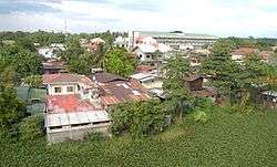
Malasiqui
| Malasiqui | ||
|---|---|---|
| Municipality | ||
| Municipality of Malasiqui | ||
 | ||
| ||
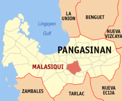 Map of Pangasinan with Malasiqui highlighted | ||
.svg.png) Malasiqui Location within the Philippines | ||
| Coordinates: 15°55′N 120°25′E / 15.92°N 120.42°ECoordinates: 15°55′N 120°25′E / 15.92°N 120.42°E | ||
| Country |
| |
| Region | Ilocos Region (Region I) | |
| Province | Pangasinan | |
| District | 3rd district of Pangasinan | |
| Founded | January 22, 1671 | |
| Barangays | 73 (see Barangays) | |
| Government [1] | ||
| • Type | Sangguniang Bayan | |
| • Mayor | Noel Anthony Geslani | |
| • Vice Mayor | Armando Domantay Sr. | |
| • Electorate | 70,990 voters (2016) | |
| Area [2] | ||
| • Total | 131.37 km2 (50.72 sq mi) | |
| Population (2015 census)[3] | ||
| • Total | 130,275 | |
| • Density | 990/km2 (2,600/sq mi) | |
| Time zone | UTC+8 (PST) | |
| ZIP code | 2421 | |
| PSGC | 015524000 | |
| IDD : area code | +63 (0)75 | |
| Climate type | Tropical monsoon climate | |
| Income class | 1st municipal income class | |
| Revenue (₱) | 245,728,683.20 (2016) [4] | |
| Poverty incidence | 19.10 (2012)[5] | |
| Native languages |
Pangasinan Ilocano Tagalog | |

Malasiqui, officially the Municipality of Malasiqui, (Pangasinan: Baley na Malasiqui; Ilokano: Ili ti Malasiqui; Tagalog: Bayan ng Malasiqui), is a 1st class municipality in the province of Pangasinan, Philippines. According to the 2015 census, it has a population of 130,275 people.[3]
It is mainly an agricultural municipality with rice, corn and tropical lowland vegetables as main crops. It is also famous for its mango fruits having one of the largest concentration of mango tree population in the Philippines.
Etymology
The word Malasiqui originates from the Pangasinan root word lasi meaning lightning. With prefix ma indicating high degree and suffix qui indicating place - Malasiqui means "place full of lightning".
History
The municipality traces its origins during the middle of the 17th century when Spanish friars opened a mission intended to convert the native population to Catholicism. The most probable founding year was 1671 when Spanish civil authorities in Manila gave the license for the creation of the town. There were no organized communities in the area before the Spaniards arrived. Attempts to group families into a settlement may have started as early as 1665. The present site was then heavily forested with small family groups scattered along banks of small rivers and creeks. The socio-political history of the municipality parallels that of the Pangasinan province and the country in general. Its history is punctuated by periods of foreign domination first by the Spanish, then by the United States and briefly by the Japanese during the 2nd World War. The population participated heavily in some of the bloodiest rebellions during the Spanish period. Catholicism and other Christian sects dominate the religious life of the people. Ethnically, it is one of the few places in the province of Pangasinan which did not experience in-migration from other regions of the country. Consequently, Pangasinanse is the dominant ethnic group with almost no other ethnic groups mixing into the locality.
The poblacion or town center, is recently experiencing high commercial growth spurred mainly by high consumer spending generated by increase in family incomes attributable to earnings of OFWs (Overseas Filipino Workers). The estimate of OFW population as a percentage of adult labor force is as much as 22% - one of the highest rates in the Philippines. The OFW phenomenon is so significant that almost all households have at least one member working outside of the country.[6]
Barangays
Malasiqui is politically subdivided into 73 barangays.
- Abonagan
- Agdao
- Alacan
- Aliaga
- Amacalan
- Anolid
- Apaya
- Asin Este
- Asin Weste
- Bacundao Este
- Bacundao Weste
- Bakitiw
- Balite
- Banawang
- Barang
- Bawer
- Binalay
- Bobon
- Bolaoit
- Bongar
- Butao
- Cabatling
- Cabueldatan
- Calbueg
- Canan Norte
- Canan Sur
- Cawayan Bogtong
- Don Pedro
- Gatang
- Goliman
- Gomez
- Guilig
- Ican
- Ingalagala
- Lareg-lareg
- Lasip
- Lepa
- Loqueb Este
- Loqueb Norte
- Loqueb Sur
- Lunec
- Mabulitec
- Malimpec
- Manggan-Dampay
- Nancapian
- Nalsian Norte
- Nalsian Sur
- Nansangaan
- Olea
- Pacuan
- Palapar Norte
- Palapar Sur
- Palong
- Pamaranum
- Pasima
- Payar
- Poblacion
- Polong Norte
- Polong Sur
- Potiocan
- San Julian
- Tabo-Sili
- Tobor
- Talospatang
- Taloy
- Taloyan
- Tambac
- Tolonguat
- Tomling
- Umando
- Viado
- Waig
- Warey
Demographics
| Population census of Malasiqui | ||
|---|---|---|
| Year | Pop. | ±% p.a. |
| 1903 | 14,550 | — |
| 1918 | 22,747 | +3.02% |
| 1939 | 33,660 | +1.88% |
| 1948 | 40,786 | +2.16% |
| 1960 | 50,730 | +1.83% |
| 1970 | 61,423 | +1.93% |
| 1975 | 67,489 | +1.91% |
| 1980 | 70,905 | +0.99% |
| 1990 | 92,053 | +2.65% |
| 1995 | 101,056 | +1.76% |
| 2000 | 113,190 | +2.46% |
| 2007 | 122,820 | +1.13% |
| 2010 | 123,566 | +0.22% |
| 2015 | 130,275 | +1.01% |
| Source: Philippine Statistics Authority[3][7][8][9] | ||
Climate
| Climate data for Malasiqui, Pangasinan | |||||||||||||
|---|---|---|---|---|---|---|---|---|---|---|---|---|---|
| Month | Jan | Feb | Mar | Apr | May | Jun | Jul | Aug | Sep | Oct | Nov | Dec | Year |
| Average high °C (°F) | 31 (88) |
31 (88) |
31 (88) |
33 (91) |
32 (90) |
32 (90) |
30 (86) |
30 (86) |
30 (86) |
31 (88) |
31 (88) |
31 (88) |
31 (88) |
| Average low °C (°F) | 21 (70) |
21 (70) |
22 (72) |
24 (75) |
24 (75) |
24 (75) |
23 (73) |
23 (73) |
23 (73) |
23 (73) |
23 (73) |
22 (72) |
23 (73) |
| Average precipitation mm (inches) | 5.1 (0.201) |
11.6 (0.457) |
21.1 (0.831) |
27.7 (1.091) |
232.9 (9.169) |
350.8 (13.811) |
679.8 (26.764) |
733.1 (28.862) |
505 (19.88) |
176.6 (6.953) |
67.2 (2.646) |
17.7 (0.697) |
2,828.6 (111.362) |
| Average rainy days | 3 | 3 | 3 | 4 | 14 | 18 | 23 | 25 | 22 | 15 | 8 | 4 | 142 |
| Source: World Weather Online[10] | |||||||||||||
Tourism
The Town Fiesta is celebrated January 17 thru 22 every year.[11] Points of interests include:
- Malasiqui Agno Valley College
- Perpetual Help College of Pangasinan
- Harvest Festival
- Assembly of God
- Rep. Rachel "Baby" Arenas farm
- Monastery of the Poor Clares of St. James the Apostle
- Archdiocese of Lingayen-Dagupan's first cloistered monastery
- Malasiqui Central School [12]
- Centeno Farm Resort and Ecohills Resort
- Barangay Lareg-Lareg and the Arenas Civic Center
- Magic Mall
- St. Ildephonse of Seville Parish Church (Malasiqui)
Image gallery
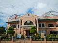 Town hall
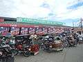 Public Market
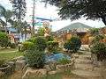 Public Park and Plaza
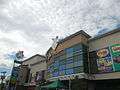 Magic Malasiqui Mall
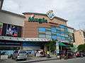 Magic Mall
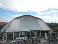 Dome of Arenas Civic Center
Notes
- ↑ "Municipality". Quezon City, Philippines: Department of the Interior and Local Government. Retrieved 31 May 2013.
- ↑ "Province: Pangasinan". PSGC Interactive. Quezon City, Philippines: Philippine Statistics Authority. Retrieved 12 November 2016.
- 1 2 3 Census of Population (2015). "Region I (Ilocos Region)". Total Population by Province, City, Municipality and Barangay. PSA. Retrieved 20 June 2016.
- ↑ "Pangasinan : Cities and Municipalities Competitiveness Index". Makati City, Philippines: National Competitiveness Council (Philippines). Archived from the original on 28 January 2017. Retrieved 28 January 2017.
- ↑ "PSA Releases the 2012 Municipal and City Level Poverty Estimates". Quezon City, Philippines: Philippine Statistics Authority. Retrieved 28 January 2017.
- ↑ http://pangasinan.org/malasiqui/
- ↑ Census of Population and Housing (2010). "Region I (Ilocos Region)". Total Population by Province, City, Municipality and Barangay. NSO. Retrieved 29 June 2016.
- ↑ Censuses of Population (1903–2007). "Region I (Ilocos Region)". Table 1. Population Enumerated in Various Censuses by Province/Highly Urbanized City: 1903 to 2007. NSO.
- ↑ "Province of Pangasinan". Municipality Population Data. Local Water Utilities Administration Research Division. Retrieved 17 December 2016.
- ↑ "Malasiqui, Pangasinan: Average Temperatures and Rainfall". World Weather Online. Retrieved 12 October 2015.
- ↑ "Archived copy". Archived from the original on 2013-06-24. Retrieved 2012-12-20.
- ↑ http://www.philstar.com/entertainment/2012/11/26/873761/showbiz-politics-blend-rep-baby-a%E2%80%99s-b-day-thanksgiving-event
External links
| Wikimedia Commons has media related to Malasiqui. |
- Municipal Profile at the National Competitiveness Council of the Philippines
- Malasiqui at the Pangasinan Government Website
- Local Governance Performance Management System
- Philippine Standard Geographic Code
- Philippine Census Information
- Pangasinan.org : Malasiqui Family and School Reunion Archives
Places adjacent to Malasiqui | ||||||||||
|---|---|---|---|---|---|---|---|---|---|---|
| ||||||||||
