Normandale, New Zealand
| Normandale | |
|---|---|
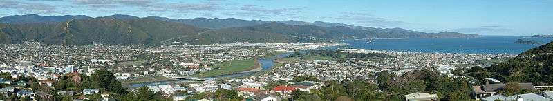
 View toward Wellington from the top of Normandale Road | |
| Basic information | |
| Region | Wellington Region |
| Local authority | Lower Hutt City |
| Population | 2,085 (2006 [1]) |
| Surrounds | |
| North | Belmont Regional Park |
| Northeast | Tirohanga |
| East | Harbour View |
| Southeast | Melling |
| South | Alicetown |
| West | Maungaraki |
Normandale is a suburb of Lower Hutt City situated at the bottom of the North Island of New Zealand. The suburb is located on the western hills of the Hutt Valley, and is a five-minute drive from the Lower Hutt city center.[2]
It consists of two main roads and the hills between: Normandale Road, starting with the bridge from Alicetown over State Highway 2 / Western Hutt Road and the Melling railway line; and Miromiro Road, which branches off after the bridge. Normandale Road is almost 4.5 kilometers long, the top few kilometres of which (around 200m altitude) are mostly lifestyle blocks, and connects to Sweetacres Drive, Belmont. From the top of Miromiro Road, Dowse Drive connects upward to the nearest suburb Maungaraki, with Poto Road connecting downward to Normandale Road in the opposite direction. The other connecting roads meet Normandale Road: Pokohiwi Road to Pekanga Road in the middle, and Stratton Street to Cottle Park Drive at the upper end next to Belmont Regional Park.
Normandale is home to the historic woodland reserve Jubilee Park,[2] a primary school,[3] a kindergarten,[4] a church,[5] and a dog boarding kennel,[6] but is otherwise entirely residential.
Jubilee Park

Jubilee Park opened in 1940 to commemorate Wellington's centenary (and the 50th anniversary of Lower Hutt a year later). Mostly consisting of native bush, it also includes sites of houses built in the 1890s, a replica pioneer hut with the original chimney, heritage plantings, picnic areas, bush walks, three lawns, and a calisthenics station.[2]
Hutt Minoh Friendship House
Jubilee Park contains Hutt Minoh Friendship House, a Heritage New Zealand category 1 building. Originally named Norbury, it was built in 1904 by Lower Hutt's first mayor William Fitzherbert, to house his daughter Alice and her husband George William von Zedlitz, Victoria University's first professor of modern languages.[7] It was acquired by the City Council in 1945 to house the park caretaker. Today it is used to promote Japanese culture and Lower Hutt's link with its sister city Minoh, Osaka, whose mayor funded its restoration.[2] It includes New Zealand's first Kyūdō dojo.[8]
History
Normandale was founded in 1901 under the village settlement scheme of New Zealand's first political party government, along with its westerly neighbours Maungaraki and Korokoro.[2] It was named after Ann Normandale, mother-in-law of Richard Seddon. It was initially part of Hutt County, and became a part of Lower Hutt City on 6 October 1957.[9]
Image gallery
References
- ↑ "2006 Demographic Profile". Hutt City Council. Archived from the original on 2 June 2010. Retrieved 26 November 2017.
- 1 2 3 4 5 "Families flock to handy Normandale". The Dominion Post. 10 May 2012. Retrieved 26 November 2017.
- ↑ "Normandale School". Retrieved 26 November 2017.
- ↑ "Normandale Playcenter". Wellington Playcenter Association. Retrieved 26 November 2017.
- ↑ "St Aidan's on the Hill Normandale/Maungaraki". Hutt City Uniting Congregations. Retrieved 26 November 2017.
- ↑ "Waglands Dogs' Holiday Retreat". 2011. Retrieved 26 November 2017.
- ↑ "About: Venue". Hutt Minoh Friendship House Trust. Retrieved 26 November 2017.
- ↑ Sue Lytollis (16 October 2015). "NZ's first public Kyudo Dojo here at Minoh House". Hutt Minoh Friendship House Trust. Retrieved 26 November 2017.
- ↑ "Normandale marks anniversary". Petone Herald. Archived from the original on 15 October 2008. Retrieved 26 November 2017.
Coordinates: 41°12′09″S 174°53′32″E / 41.20250°S 174.89222°E