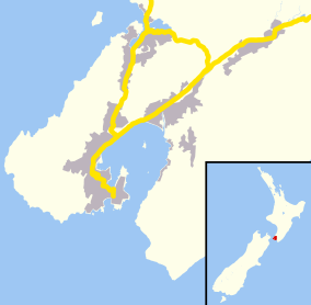
Thorndon, New Zealand
| Thorndon | |
|---|---|
 Thorndon | |
| Basic information | |
| Local authority | Wellington City |
| Coordinates | 41°16′30″S 174°46′40″E / 41.2750°S 174.7779°ECoordinates: 41°16′30″S 174°46′40″E / 41.2750°S 174.7779°E |
| Population | 3,840[1] (2006) |
| Facilities | |
| Train station(s) | Wellington Railway Station |
| Ferry terminal(s) | Wellington Interislander Terminal, Wellington Bluebridge Terminal |
| Surrounds | |
| North | Wadestown |
| East | Wellington Harbour |
| South | Wellington CBD, Kelburn |
| Southwest | Northland |
| Northwest | Wilton |
and the old wooden administration building
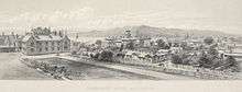
circa 1877 on the site of the Beehive
Old Parliament Buildings at the left
on the site of the Parliamentary Library
Thorndon Quay and Mulgrave Street
Pipitea Pā with St Paul's pro-cathedral
.jpg)
Thorndon is a historic inner suburb of Wellington, the capital city of New Zealand. Because the suburb is relatively level compared to the hilly terrain elsewhere in Wellington it contained Wellington's elite residential area until its best was destroyed in the 1960s by a new motorway and the erection of tall office buildings on the sites of its Molesworth Street retail and service businesses.
Before Thorndon was Thorndon its southern end was Pipitea and more recently Pipitea Marae and the land under the houses of parliament have been separated from Thorndon and Pipitea returned to them.
Thorndon combines upmarket residential accommodation and the home of government, and is located at the northern end of the Central Business District.
Features
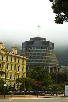
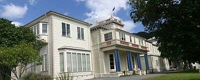
The buildings (dating from 1899) of the New Zealand Parliament are located in Thorndon. Thorndon is also the location of many Government departments including the National Library (1987) and Archives New Zealand (1957). Thorndon is surrounded by major transportation links. To the west, towards the foot of Te Ahumairangi Hill (formerly known as Tinakori Hill) which hangs above the suburb, is the Wellington Urban Motorway, part of New Zealand state highway network. Schools located in Thorndon include Wellington Girls' College (1883), St Mary's College (1850), Queen Margaret College (1919) and primary schools Thorndon School (1852) and Sacred Heart Cathedral School (1850). Thorndon is home to two Cathedrals: Anglican St Paul's Cathedral (completed in 1998) built to replace the former pro-cathedral, Old Saint Paul's (1866) and Catholic Sacred Heart Cathedral opened in 1901 to replace the destroyed St Mary's Cathedral dating from 1851. Katherine Mansfield Birthplace is located in Thorndon, and is the house where Katherine Mansfield grew up. The Thistle Inn is one of New Zealand's oldest public houses, originally built in 1840. Artist Rita Angus lived in Thorndon from 1955 to her death in 1970. Her 1877 cottage is now used to host the Rita Angus Residency for visiting artists. Westpac Stadium, one of New Zealand's top sports venues, is located nearby and the Thorndon Tennis (and Squash) Club, established in the 19th century, is one of the oldest in the world. Many embassies, high commissions and consulates are located in Thorndon including: the US, Chinese, Cuban, German, Italian, Philippine, Thai and Turkish Embassies; the Australian, British, Canadian, Cook Islands, Fijian, Indian, and Niue High Commissions; and the Norwegian and Swedish Consulates-General.
Events
The Thorndon Fair is held annually, usually on the first Sunday of December. The fair has many stalls selling crafts and second-hand goods and is held for the benefit of Thorndon School. It has taken place for many years and is one of the main community events held in Thorndon. Parts of Tinakori Road and Hill Street are closed during the fair.
Geographic boundaries
Thorndon occupies the northern end of the narrow coastal plain that makes up the heart of Wellington. It is flanked by the green hills of Wadestown and Kelburn to the west and south, and the port facilities of Wellington Harbour to the east.
The boundaries of Thorndon form an approximate triangle. Starting from the lower south-west corner, at the intersection of Glenmore St and Collins Tce, the boundary goes up through Tinakori Hill, across through Weld St and along to Baker St. Then the boundary follows the west side of Thorndon Quay down until Hill St, where it goes across to Bowen St, Tinakori Road and Glenmore St (until Collins Tce).
Naming
One of the few comparatively flat areas on the harbour, Thorndon became a significant part of Port Nicholson's first organised European settlement in 1840. European settlers built their houses alongside the Maori settlement of Pipitea and named their portion after Thorndon, the family residence of W H F Petre, a director of their organisation, The New Zealand Company.[2]
Culture
Pipitea Marae is located in Thorndon. It is a marae (tribal meeting ground) for Taranaki Whānui ki te Upoko o te Ika and Te Āti Awa, and includes Te Upoko o te Ika a Māui wharenui (meeting house).[3][4]
Notable residents
Ex officio
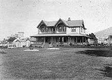
- Governor General Bowen Street from 1871 to 1907[note 1] on what is now the site of the Beehive
- Prime Minister at 260 Tinakori Road
- Cabinet ministers
- Anglican Bishop of Wellington
- Catholic Archbishop of Wellington and Metropolitan of New Zealand
Private citizens

Hobson Street
- Charles Abraham (bishop of Wellington)
- Alfred Brandon (politician)
- Alfred Brandon (mayor)
- Alfred Brandon (lawyer)
- William Henry Clayton
- Charles Clifford
- John Duncan (1839–1919) now the site of the Australian High Commission
- Robert Hart (politician)
- Charles Beard Izard
T C Williams's tower in the background
- Jacob Joseph (merchant)
- Arthur Myers, Cabinet Minister[5]
- Joseph Edward Nathan
- Joseph Nathan merchant, founded Glaxo now GlaxoSmithKline
- Evelyn Margaret Page
- Robert Pharazyn merchant and runholder
- William Pharazyn merchant and runholder
- Robert Stains
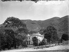
- Thomas Coldham Williams (1825–1912) runholder now Queen Margaret College
Tinakori Road
- Harold Beauchamp banker
- Elsdon Best
- George Hunter (mayor)
- Walter Woods Johnston
- Nathaniel Levin merchant
- William Levin merchant and runholder now Pendennis, 15 Burnell Avenue
- Douglas Lilburn Ascot Street
- Katherine Mansfield[note 2]
- Andrew Todd (New Zealand)
T C Williams's house is said to have had more than 30 rooms
Fitzherbert Terrace
- John Johnston (New Zealand politician) merchant and runholder, driveway Katherine Avenue, Queen Margaret College and Thorndon tennis club courts
Hill Street
.jpg)
Sydney Street West
Bowen Street
Murphy Street
- Arthur Donald Stuart Duncan
- Robyn Cooke took the suburb's name when raised to a life peerage
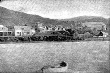
Thorndon Quay
Thorndon Esplanade
_(20986497464).jpg)
"Wellington's Show Walk". Thorndon Esplanade with its baths and shrubs lies beneath Aotea Quay. Its band rotunda was sent to Central Park in 1921. Built at the end of the 1880s on the reclamation of the Manawatu Railway Company and intended to be a place of fashionable display it did not survive the first World War. It had become dirty and disreputable suffering from the increased activity in the smoky railway yards alongside.[6] Its coprosmas and "gallant pohutukawas" never grew larger seeming to lack any care from the City Council but the wind and the poor soil and the grimy railway yard discouraged plants and visitors. "Lovers seemed to monopolise the gardens in the evenings".[7]
The salt water baths were closed in 1920 and the superstructure moved to Evans Bay for dressing sheds.[8] New baths opened in Murphy Street in November 1924 with certain hours set aside for mixed bathing.[9][10]
Notes
- ↑ when Government House was taken over by Parliament following the destruction of Parliament Buildings by fire, (that building was eventually demolished to erect the Beehive) and a new residence built by the Basin Reserve
- ↑ both her birthplace and her family's residence after 1898 at 75 Tinakori Road — destroyed for the motorway.
References
- ↑ Quickstats about Thorndon-Tinakori Road
- ↑ E J Wakefield, Adventure in New Zealand, Vol.I, p. 100
- ↑ "Te Kāhui Māngai directory". tkm.govt.nz. Te Puni Kōkiri.
- ↑ "Māori Maps". maorimaps.com. Te Potiki National Trust.
- ↑ Paul Goldsmith and Michael Bassett, The Myers, David Ling Publishing Ltd, Auckland, 2007.
- ↑ The Evening Post, 10 November 1930, Page 10
- ↑ The Evening Post, 30 January 1915, Page 3
- ↑ The Evening Post 13 September 1920, page 7
- ↑ The Evening Post 25 November 1924, page 6
- ↑ The Evening Post 1 December 1924
External links
| Wikimedia Commons has media related to Thorndon. |