Waiwhetū
| Waiwhetū | |
|---|---|
 | |
| Basic information | |
| Local authority | Lower Hutt City |
| Population | 3,951 (2006[1]) |
| Surrounds | |
| Northeast | Waterloo |
| South | Gracefield |
| Southwest | Moera |
| Northwest | Woburn |
Waiwhetū is an eastern suburb of Lower Hutt in the Wellington Region situated in the south of the North Island of New Zealand.
In the 19th-century period of European settlement it was worked by Irish-born Alfred Ludlam, who was a member of three of New Zealand's four earliest parliaments. In the 1840s it was set aside as a native reserve for the Te Āti Awa tribe. In the 1930s the New Zealand government compulsorily acquired the land and built new homes for Te Āti Awa.[2]
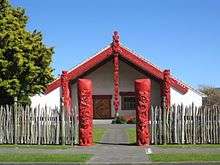
The suburb includes Waiwhetū Marae, a marae (tribal meeting-ground) of Taranaki Whānui ki te Upoko o te Ika and of Te Āti Awa. The marae, founded in 1960, includes the Arohanui ki te Tangata wharenui (meeting house).[3][4]
Waiwhetū Marae features a number of significant carvings and has associations with a number of notable Māori artists, including Rangi Hetet (who did much of the original carving for the marae), his wife Erenora Puketapu-Hetet and their daughter Veranoa Hetet. The marae is associated with Ihakara Puketapu and Ihaia Porutu Puketapu.[5][6]
References
- ↑ "Hutt City Council - 2006 Hutt City Demographic Profile". huttcity.govt.nz. Hutt City Council.
- ↑ "Hutt Valley - south". teara.govt.nz. Te Ara: The Encyclopaedia of New Zealand, Ministry for Culture and Heritage.
Waiwhetū is built on land largely set aside as a native reserve for its former owners, the Te Āti Awa tribe, in the 1840s. The government compulsorily acquired the land in the 1930s, building new homes for Te Āti Awa people.
- ↑ "Te Kāhui Māngai directory". tkm.govt.nz. Te Puni Kōkiri.
- ↑ "Māori Maps". maorimaps.com. Te Potiki National Trust.
- ↑ "Waiwhetū marae 41351". teara.govt.nz. Te Ara: The Encyclopaedia of New Zealand, Ministry for Culture and Heritage.
- ↑
Compare:
"Waiwhetū marae 13468". teara.govt.nz. Te Ara: The Encyclopaedia of New Zealand, Ministry for Culture and Heritage.
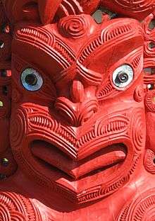
In 1985, 10 carved pou (posts) were installed at Waiwhetū marae, Lower Hutt, as part of the marae's 25th anniversary celebrations. This pou represents Īhāia Pōrutu Puketapu, a prominent local Te Āti Awa chief.