Mahoning Township, Armstrong County, Pennsylvania
| Mahoning Township, Armstrong County, Pennsylvania | |
|---|---|
| Township | |
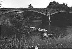 The historic Bridge between Madison and Mahoning Townships | |
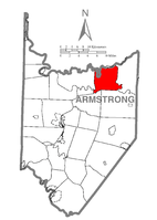 Map of Armstrong County, Pennsylvania highlighting Mahoning Township | |
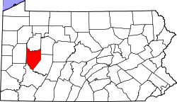 Map of Armstrong County, Pennsylvania | |
| Country | United States |
| State | Pennsylvania |
| County | Armstrong |
| Settled | 1787 |
| Incorporated | 1851 |
| Area[1] | |
| • Total | 25.22 sq mi (65.32 km2) |
| • Land | 24.78 sq mi (64.19 km2) |
| • Water | 0.44 sq mi (1.13 km2) |
| Population (2010) | |
| • Total | 1,425 |
| • Estimate (2016)[2] | 1,358 |
| • Density | 54.80/sq mi (21.16/km2) |
| Time zone | UTC-5 (Eastern (EST)) |
| • Summer (DST) | UTC-4 (EDT) |
| FIPS code | 42-005-46632 |
Mahoning Township is a township in Armstrong County, Pennsylvania, United States. The population was 1,425 at the 2010 census.[3]
History
The Bridge between Madison and Mahoning Townships and Colwell Cut Viaduct are listed on the National Register of Historic Places.[4]
Geography
Mahoning Township is located along the northern border of Armstrong County and is bordered by Clarion County to the north across the river
According to the United States Census Bureau, the township has a total area of 25.2 square miles (65.3 km2), of which 24.8 square miles (64.2 km2) is land and 0.42 square miles (1.1 km2), or 1.73%, is water.[3]
Demographics
| Historical population | |||
|---|---|---|---|
| Census | Pop. | %± | |
| 2010 | 1,425 | — | |
| Est. 2016 | 1,358 | [2] | −4.7% |
| U.S. Decennial Census[5] | |||
As of the census[6] of 2000, there were 1,502 people, 607 households, and 449 families residing in the township. The population density was 60.5 people per square mile (23.3/km²). There were 667 housing units at an average density of 26.8/sq mi (10.4/km²). The racial makeup of the township was 99.20% White, 0.27% African American, 0.07% Native American, 0.07% Pacific Islander, and 0.40% from two or more races.
There were 607 households, out of which 30.1% had children under the age of 18 living with them, 63.8% were married couples living together, 6.4% had a female householder with no husband present, and 26.0% were non-families. 22.7% of all households were made up of individuals, and 12.0% had someone living alone who was 65 years of age or older. The average household size was 2.47 and the average family size was 2.90.
In the township the population was spread out, with 23.8% under the age of 18, 8.2% from 18 to 24, 25.4% from 25 to 44, 25.0% from 45 to 64, and 17.5% who were 65 years of age or older. The median age was 40 years. For every 100 females there were 97.1 males. For every 100 females age 18 and over, there were 94.2 males.
The median income for a household in the township was $29,934, and the median income for a family was $35,337. Males had a median income of $26,891 versus $16,813 for females. The per capita income for the township was $13,833. About 7.3% of families and 8.1% of the population were below the poverty line, including 12.2% of those under age 18 and 4.9% of those age 65 or over.
References
- ↑ "2016 U.S. Gazetteer Files". United States Census Bureau. Retrieved Aug 13, 2017.
- 1 2 "Population and Housing Unit Estimates". Retrieved June 9, 2017.
- 1 2 "Geographic Identifiers: 2010 Demographic Profile Data (G001): Mahoning township, Armstrong County, Pennsylvania". U.S. Census Bureau, American Factfinder. Retrieved August 1, 2013.
- ↑ National Park Service (2010-07-09). "National Register Information System". National Register of Historic Places. National Park Service.
- ↑ "Census of Population and Housing". Census.gov. Retrieved June 4, 2016.
- ↑ "American FactFinder". United States Census Bureau. Retrieved 2008-01-31.
Municipalities and communities of Armstrong County, Pennsylvania, United States | ||
|---|---|---|
| City | | |
| Boroughs | ||
| Townships | ||
| CDPs | ||
| Unincorporated communities | ||
| Counties |  Map of the Pittsburgh Tri-State with green counties in the metropolitan area and yellow counties in the combined area. | |
|---|---|---|
| Major cities | ||
| Cities and towns 15k-50k (in 2010) | ||
| Airports | ||
| Topics | ||
| ||
Coordinates: 40°57′26″N 79°20′38″W / 40.95722°N 79.34389°W