Interlaken, New Jersey
| Interlaken, New Jersey | |
|---|---|
| Borough | |
| Borough of Interlaken | |
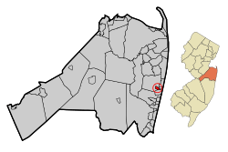 Map of Interlaken in Monmouth County. Inset: Location of Monmouth County highlighted in the State of New Jersey. | |
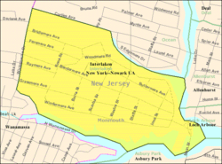 Census Bureau map of Interlaken, New Jersey | |
| Coordinates: 40°14′04″N 74°00′57″W / 40.234313°N 74.015939°WCoordinates: 40°14′04″N 74°00′57″W / 40.234313°N 74.015939°W[1][2] | |
| Country |
|
| State |
|
| County | Monmouth |
| Incorporated | May 3, 1922 |
| Named for | Interlaken, Switzerland |
| Government[3] | |
| • Type | Borough |
| • Body | Borough Council |
| • Mayor | Michael Nohilly (R, term ends December 31, 2019)[4][5] |
| • Municipal clerk | Lori Reibrich[6] |
| Area[1] | |
| • Total | 0.383 sq mi (0.993 km2) |
| • Land | 0.330 sq mi (0.856 km2) |
| • Water | 0.053 sq mi (0.138 km2) 13.85% |
| Area rank |
551st of 566 in state 49th of 53 in county[1] |
| Elevation[7] | 16 ft (5 m) |
| Population (2010 Census)[8][9][10] | |
| • Total | 820 |
| • Estimate (2016)[11] | 801 |
| • Rank |
543rd of 566 in state 50th of 53 in county[12] |
| • Density | 2,482.3/sq mi (958.4/km2) |
| • Density rank |
252nd of 566 in state 30th of 53 in county[12] |
| Time zone | UTC-5 (Eastern (EST)) |
| • Summer (DST) | UTC-4 (Eastern (EDT)) |
| ZIP code | 07712[13][14] |
| Area code(s) | 732[15] |
| FIPS code | 3402534200[1][16][17] |
| GNIS feature ID | 0885261[1][18] |
| Website |
www |
Interlaken is a borough in Monmouth County, New Jersey, United States. As of the 2010 United States Census, the borough's population was 820,[8][9][10] reflecting a decline of 80 (-8.9%) from the 900 counted in the 2000 Census, which had in turn declined by 10 (-1.1%) from the 910 counted in the 1990 Census.[19]
Interlaken was formed as a borough by an act of the New Jersey Legislature on March 11, 1922, from portions of Ocean Township, based on the results of a referendum held on May 3, 1922.[20][21]
Interlaken is a dry town where alcohol cannot be sold.[22][23]
History
The area that is now Interlaken was purchased in 1667 by Gavin Drummond from the Lenape Native Americans. It was later part of Ocean Township, which had seceded from Shrewsbury Township in 1849 and included at the time present-day Eatontown, Neptune Township, Neptune City, Avon-by-the-Sea, Bradley Beach, Asbury Park, Allenhurst, Deal, Long Branch, West Long Branch, Loch Arbour, Monmouth Beach, Sea Bright and Oceanport, along with Interlaken itself.[24]
Dr. Francis Weld, a Boston physician, bought a 364-acre (1.47 km2) tract and named it Interlaken Farm, after Interlaken, a peninsula in Switzerland situated between two lakes, that they had just visited, which was similar to the borough's location between two sections of Deal Lake.[25] Weld established the Interlaken Land Company in 1890 to turn his farm into a residential community with avenues named after English lakes and cross streets named after the islands in the Hebrides in the Irish Sea. While the initial effort did not succeed, the Stormfelz-Lovely-Neville Company was hired in 1905 to continue the building project, and the community began its growth.[24]
Interlaken was formed as a borough on March 11, 1922, based on the results of a referendum held on May 3, 1922.[20] The first Mayor and Council of Interlaken were seated on June 26, 1922.[24]
Interlaken remains entirely residential, as was originally intended by its developers.[24]
Geography
According to the United States Census Bureau, the borough had a total area of 0.383 square miles (0.993 km2), including 0.330 square miles (0.856 km2) of land and 0.053 square miles (0.138 km2) of water (13.85%).[1][2]
The borough borders the Monmouth County community of Allenhurst, Asbury Park, Loch Arbour and Ocean Township.[26]
Deal Lake covers 158 acres (64 ha) and is overseen by the Deal Lake Commission, which was established in 1974. Seven municipalities border the lake, accounting for 27 miles (43 km) of shoreline, also including Allenhurst, Asbury Park, Deal, Loch Arbour, Neptune Township and Ocean Township.[27]
Demographics
| Historical population | |||
|---|---|---|---|
| Census | Pop. | %± | |
| 1930 | 545 | — | |
| 1940 | 787 | 44.4% | |
| 1950 | 833 | 5.8% | |
| 1960 | 1,168 | 40.2% | |
| 1970 | 1,182 | 1.2% | |
| 1980 | 1,037 | −12.3% | |
| 1990 | 910 | −12.2% | |
| 2000 | 900 | −1.1% | |
| 2010 | 820 | −8.9% | |
| Est. 2016 | 801 | [11][28] | −2.3% |
| Population sources:1930[29] 1930-1990[30] 2000[31][32] 2010[8][9][10] | |||
Census 2010
As of the 2010 United States Census, there were 820 people, 361 households, and 237.2 families residing in the borough. The population density was 2,482.3 per square mile (958.4/km2). There were 393 housing units at an average density of 1,189.7 per square mile (459.3/km2). The racial makeup of the borough was 98.41% (807) White, 0.00% (0) Black or African American, 0.00% (0) Native American, 0.49% (4) Asian, 0.00% (0) Pacific Islander, 0.37% (3) from other races, and 0.73% (6) from two or more races. Hispanic or Latino of any race were 1.71% (14) of the population.[8]
There were 361 households out of which 18.3% had children under the age of 18 living with them, 58.7% were married couples living together, 5.5% had a female householder with no husband present, and 34.3% were non-families. 26.3% of all households were made up of individuals, and 16.3% had someone living alone who was 65 years of age or older. The average household size was 2.27 and the average family size was 2.76.[8]
In the borough, the population was spread out with 14.5% under the age of 18, 4.8% from 18 to 24, 14.5% from 25 to 44, 39.6% from 45 to 64, and 26.6% who were 65 years of age or older. The median age was 54.3 years. For every 100 females there were 90.3 males. For every 100 females ages 18 and older there were 90.0 males.[8]
The Census Bureau's 2006-2010 American Community Survey showed that (in 2010 inflation-adjusted dollars) median household income was $116,000 (with a margin of error of +/- $16,207) and the median family income was $137,500 (+/- $17,077). Males had a median income of $116,250 (+/- $10,733) versus $60,833 (+/- $21,986) for females. The per capita income for the borough was $72,484 (+/- $11,388). About 2.7% of families and 2.1% of the population were below the poverty line, including 0.0% of those under age 18 and 4.2% of those age 65 or over.[33]
Census 2000
As of the 2000 United States Census[16] there were 900 people, 386 households, and 260 families residing in the borough. The population density was 2,556.2 people per square mile (992.8/km2). There were 397 housing units at an average density of 1,127.6 per square mile (438.0/km2). The racial makeup of the borough was 98.67% White, 0.22% Asian, 0.11% Pacific Islander, and 1.00% from two or more races. Hispanic or Latino of any race were 1.11% of the population.[31][32]
There were 386 households out of which 21.0% had children under the age of 18 living with them, 59.1% were married couples living together, 6.7% had a female householder with no husband present, and 32.4% were non-families. 27.5% of all households were made up of individuals and 15.8% had someone living alone who was 65 years of age or older. The average household size was 2.33 and the average family size was 2.86.[31][32]
In the borough the population was spread out with 17.9% under the age of 18, 4.0% from 18 to 24, 21.9% from 25 to 44, 33.4% from 45 to 64, and 22.8% who were 65 years of age or older. The median age was 48 years. For every 100 females, there were 93.5 males. For every 100 females age 18 and over, there were 89.0 males.[31][32]
The median income for a household in the borough was $82,842, and the median income for a family was $104,618. Males had a median income of $81,203 versus $59,063 for females. The per capita income for the borough was $47,307. About 1.5% of families and 3.0% of the population were below the poverty line, including 3.7% of those under age 18 and 2.0% of those age 65 or over.[31][32]
Government
Local government
Interlaken is governed under the Borough form of New Jersey municipal government. The governing body consists of a Mayor and a Borough Council comprising six council members, with all positions elected at-large on a partisan basis as part of the November general election. A Mayor is elected directly by the voters to a four-year term of office. The Borough Council consists of six members elected to serve three-year terms on a staggered basis, with two seats coming up for election each year in a three-year cycle.[3] The Borough form of government used by Interlaken, the most common system used in the state, is a "weak mayor / strong council" government in which council members act as the legislative body with the mayor presiding at meetings and voting only in the event of a tie. The mayor can veto ordinances subject to an override by a two-thirds majority vote of the council. The mayor makes committee and liaison assignments for council members, and most appointments are made by the mayor with the advice and consent of the council.[34][35]
As of 2016, the Mayor of Interlaken is Republican Michael Nohilly, whose term of office ends on December 31, 2019. Members of the Borough Council are Council President Robert L. White (R, 2018), John Rush Butler (R, 2016; appointed to serve an unexpired term), Mervin Franks (R, 2018), John Gunn (R, 2017), William Handerhan (D, 2016) and Mindy Horowitz (R, 2017).[4][36][37][38][39][40]
In September 2016, the Borough Council selected John Rush Butler to fill the vacant seat expiring in December 2016 that had been held by Keith Miller until his resignation earlier that month; Butler will serve on an interim basis until the November 2016 general election, when voters will choose a candidate to serve the balance of the term of office.[41]
Federal, state and county representation
Interlaken is located in the 6th Congressional District[42] and is part of New Jersey's 11th state legislative district.[9][43][44]
New Jersey's Sixth Congressional District is represented by Frank Pallone (D, Long Branch).[45] New Jersey is represented in the United States Senate by Democrats Cory Booker (Newark, term ends 2021)[46] and Bob Menendez (Paramus, 2019).[47][48]
For the 2018–2019 session (Senate, General Assembly), the 11th Legislative District of the New Jersey Legislature is represented in the State Senate by Vin Gopal (D, Long Branch) and in the General Assembly by Joann Downey (D, Freehold Township) and Eric Houghtaling (D, Neptune Township).[49][50] The Governor of New Jersey is Phil Murphy (D, Middletown Township).[51] The Lieutenant Governor of New Jersey is Sheila Oliver (D, East Orange).[52]
Monmouth County is governed by a Board of Chosen Freeholders consisting of five members who are elected at-large to serve three year terms of office on a staggered basis, with either one or two seats up for election each year as part of the November general election. At an annual reorganization meeting held in the beginning of January, the board selects one of its members to serve as Director and another as Deputy Director.[53] As of 2018, Monmouth County's Freeholders are Freeholder Director Thomas A. Arnone (R, Neptune City, term as freeholder ends December 31, 2019; term as freeholder director ends 2018),[54] Freeholder Deputy Director Lillian G. Burry (R, Colts Neck Township, term as freeholder ends 2020; term as deputy director ends 2018),[55] John P. Curley (R, Middletown Township, 2018),[56] Patrick G. Impreveduto (R, Holmdel Township, 2020)[57] and Dr. Gerry P. Scharfenberger (R, Middletown Township, 2019; appointed to serve an unexpired term).[58][59] Constitutional officers elected on a countywide basis are County clerk Christine Giordano Hanlon (R, 2020; Ocean Township),[60][61] Sheriff Shaun Golden (R, 2019; Howell Township)[62][63] and Surrogate Rosemarie D. Peters (R, 2021; Middletown Township).[64]
Politics
As of March 23, 2011, there were a total of 749 registered voters in Interlaken, of which 183 (24.4%) were registered as Democrats, 371 (49.5%) were registered as Republicans and 195 (26.0%) were registered as Unaffiliated. There were no voters registered to other parties.[65]
In the 2012 presidential election, Republican Mitt Romney received 61.5% of the vote (362 cast), ahead of Democrat Barack Obama with 38.0% (224 votes), and other candidates with 0.5% (3 votes), among the 595 ballots cast by the borough's 781 registered voters (6 ballots were spoiled), for a turnout of 76.2%.[66][67] In the 2008 presidential election, Republican John McCain received 59.6% of the vote (379 cast), ahead of Democrat Barack Obama with 36.9% (235 votes) and other candidates with 1.9% (12 votes), among the 636 ballots cast by the borough's 766 registered voters, for a turnout of 83.0%.[68] In the 2004 presidential election, Republican George W. Bush received 59.0% of the vote (372 ballots cast), outpolling Democrat John Kerry with 38.8% (245 votes) and other candidates with 1.0% (8 votes), among the 631 ballots cast by the borough's 776 registered voters, for a turnout percentage of 81.3.[69]
In the 2013 gubernatorial election, Republican Chris Christie received 75.4% of the vote (383 cast), ahead of Democrat Barbara Buono with 23.4% (119 votes), and other candidates with 1.2% (6 votes), among the 523 ballots cast by the borough's 774 registered voters (15 ballots were spoiled), for a turnout of 67.6%.[70][71] In the 2009 gubernatorial election, Republican Chris Christie received 63.5% of the vote (360 ballots cast), ahead of Democrat Jon Corzine with 26.5% (150 votes), Independent Chris Daggett with 7.9% (45 votes) and other candidates with 0.5% (3 votes), among the 567 ballots cast by the borough's 760 registered voters, yielding a 74.6% turnout.[72]
Education
Interlaken is a non-operating school district. Students from Interlaken attend the schools of the West Long Branch Public Schools for pre-kindergarten through eighth grade as part of a sending/receiving relationship in which students attend on a tuition basis.[73] As of the 2014-15 school year, the district and its two schools had an enrollment of 565 students and 61.0 classroom teachers (on an FTE basis), for a student–teacher ratio of 9.3:1.[74] Schools in the district (with 2014-15 enrollment data from the National Center for Education Statistics[75]) are Betty McElmon Elementary School[76] with 241 students in pre-Kindergarten through third grade and Frank Antonides School[77] with 338 students in fourth through eighth grades.[78][79][80]
For ninth through twelfth grades, public school students attend Shore Regional High School, a regional high school located in West Long Branch that also serves students from the constituent districts of Monmouth Beach, Oceanport, Sea Bright and West Long Branch.[81][82] The high school is part of the Shore Regional High School District. As of the 2014-15 school year, the high school had an enrollment of 630 students and 58.0 classroom teachers (on an FTE basis), for a student–teacher ratio of 10.9:1.[83]
Transportation
As of May 2010, the borough had a total of 6.77 miles (10.90 km) of roadways, of which 5.84 miles (9.40 km) were maintained by the municipality and 0.93 miles (1.50 km) by Monmouth County.[84]
No major roads pass through the borough. Route 18, Route 35, Route 66 and Route 71 are accessible in its neighboring communities. The Garden State Parkway is also not too far away.
Notable people
People who were born in, residents of, or otherwise closely associated with Interlaken include:
- Danny DeVito (born 1944), actor.[85]
- Rhea Perlman (born 1948), actress.[85]
References
- 1 2 3 4 5 6 2010 Census Gazetteer Files: New Jersey County Subdivisions, United States Census Bureau. Accessed May 21, 2015.
- 1 2 US Gazetteer files: 2010, 2000, and 1990, United States Census Bureau. Accessed September 4, 2014.
- 1 2 2012 New Jersey Legislative District Data Book, Rutgers University Edward J. Bloustein School of Planning and Public Policy, March 2013, p. 58.
- 1 2 Borough Council, Borough of Interlaken. Accessed July 15, 2016.
- ↑ 2017 New Jersey Mayors Directory, New Jersey Department of Community Affairs. Accessed May 30, 2017.
- ↑ Clerk & Registrar, Borough of Interlaken. Accessed July 15, 2016.
- ↑ U.S. Geological Survey Geographic Names Information System: Borough of Interlaken, Geographic Names Information System. Accessed March 6, 2013.
- 1 2 3 4 5 6 DP-1 - Profile of General Population and Housing Characteristics: 2010 for Interlaken borough, Monmouth County, New Jersey, United States Census Bureau. Accessed July 30, 2012.
- 1 2 3 4 Municipalities Grouped by 2011-2020 Legislative Districts, New Jersey Department of State, p. 6. Accessed January 6, 2013.
- 1 2 3 Profile of General Demographic Characteristics: 2010 for Interlaken borough, New Jersey Department of Labor and Workforce Development. Accessed July 30, 2012.
- 1 2 PEPANNRES - Annual Estimates of the Resident Population: April 1, 2010 to July 1, 2016 - 2016 Population Estimates for New Jersey municipalities, United States Census Bureau. Accessed June 16, 2017.
- 1 2 GCT-PH1 Population, Housing Units, Area, and Density: 2010 - State -- County Subdivision from the 2010 Census Summary File 1 for New Jersey, United States Census Bureau. Accessed December 4, 2012.
- ↑ Look Up a ZIP Code for Interlaken, NJ, United States Postal Service. Accessed July 30, 2012.
- ↑ Zip Codes, State of New Jersey. Accessed August 28, 2013.
- ↑ Area Code Lookup - NPA NXX for Interlaken, NJ, Area-Codes.com. Accessed August 28, 2013.
- 1 2 American FactFinder, United States Census Bureau. Accessed September 4, 2014.
- ↑ A Cure for the Common Codes: New Jersey, Missouri Census Data Center. Accessed July 30, 2012.
- ↑ US Board on Geographic Names, United States Geological Survey. Accessed September 4, 2014.
- ↑ Table 7. Population for the Counties and Municipalities in New Jersey: 1990, 2000 and 2010, New Jersey Department of Labor and Workforce Development, February 2011. Accessed July 30, 2012.
- 1 2 Snyder, John P. The Story of New Jersey's Civil Boundaries: 1606-1968, Bureau of Geology and Topography; Trenton, New Jersey; 1969. p. 180. Accessed July 30, 2012.
- ↑ Staff. Acts of the One Hundred and Forty-Sixth Legislature of the State of New Jersey, pp. 118-121. New Jersey Secretary of State, 1922. Accessed October 17, 2015. "An Act to incorporate the borough of Interlaken, in the county of Monmouth"
- ↑ New Jersey Division of Alcoholic Beverage Control. New Jersey ABC list of dry towns (May 1, 2013)
- ↑ Giordano, Rita. "More towns catching liquor-license buzz; Moorestown considers ending its dry spell", The Philadelphia Inquirer, June 24, 2007. Accessed February 16, 2014.
- 1 2 3 4 The History of Interlaken Archived 2008-12-12 at the Wayback Machine., Borough of Interlaken. Accessed November 10, 2008.
- ↑ Hutchinson, Viola L. The Origin of New Jersey Place Names, New Jersey Public Library Commission, May 1945. Accessed September 2, 2015.
- ↑ Areas touching Interlaken, MapIt. Accessed July 13, 2015.
- ↑ Home Page, Deal Lake Commission. Accessed July 8, 2015. "The Deal Lake Commission was created by the seven Monmouth County, NJ towns that surround Deal Lake. The Commission was chartered in 1974 by the Borough of Allenhurst, City of Asbury Park, Borough of Deal, Borough of Interlaken, Village of Loch Arbour, Neptune Township, and Ocean Township."
- ↑ Census Estimates for New Jersey April 1, 2010 to July 1, 2016, United States Census Bureau. Accessed June 16, 2017.
- ↑ Fifteenth Census of the United States : 1930 - Population Volume I, United States Census Bureau, p. 717. Accessed July 30, 2012.
- ↑ New Jersey Resident Population by Municipality: 1930 - 1990, Workforce New Jersey Public Information Network. Accessed June 28, 2015.
- 1 2 3 4 5 Census 2000 Profiles of Demographic / Social / Economic / Housing Characteristics for Interlaken borough, New Jersey, United States Census Bureau. Accessed July 30, 2012.
- 1 2 3 4 5 DP-1: Profile of General Demographic Characteristics: 2000 - Census 2000 Summary File 1 (SF 1) 100-Percent Data for Interlaken borough, Monmouth County, New Jersey, United States Census Bureau. Accessed July 30, 2012.
- ↑ DP03: Selected Economic Characteristics from the 2006-2010 American Community Survey 5-Year Estimates for Interlaken borough, Monmouth County, New Jersey, United States Census Bureau. Accessed July 30, 2012.
- ↑ Cerra, Michael F. "Forms of Government: Everything You've Always Wanted to Know, But Were Afraid to Ask" Archived 2014-09-24 at the Wayback Machine., New Jersey State League of Municipalities. Accessed November 30, 2014.
- ↑ "Forms of Municipal Government in New Jersey", p. 6. Rutgers University Center for Government Studies. Accessed June 3, 2015.
- ↑ 2016 Municipal Data Sheet, Borough of Interlaken. Accessed July 15, 2016.
- ↑ Monmouth County Directory 2016, Monmouth County, New Jersey. Accessed July 14, 2016.
- ↑ November 3, 2015 General Election Official Results, Monmouth County, New Jersey, updated January 27, 2016. Accessed July 14, 2016.
- ↑ November 4, 2014 General Election Official Results, Monmouth County, New Jersey, updated November 24, 2014. Accessed July 14, 2016.
- ↑ Official Election Results - General Election November 5, 2013, Monmouth County, New Jersey Accessed July 14, 2016.
- ↑ Meeting Minutes September 30, 2015, Borough of Interlaken. Accessed July 15, 2016. "WHEREAS, Councilman Keith Miller resigned from his position on September 2, 2015 and... THEREFORE, BE IT RESOLVED by the Borough Council of the Borough of Interlaken, County of Monmouth and State of New Jersey that John Rush Butler be and is hereby appointed until such time as an election is held to fill the remaining unexpired term of the vacated position pursuant to N.J.S.A. 40A:16-11 and a successor is duly qualified."
- ↑ Plan Components Report, New Jersey Redistricting Commission, December 23, 2011. Accessed January 6, 2013.
- ↑ 2017 New Jersey Citizen's Guide to Government, p. 59, New Jersey League of Women Voters. Accessed May 30, 2017.
- ↑ Districts by Number for 2011-2020, New Jersey Legislature. Accessed January 6, 2013.
- ↑ Directory of Representatives: New Jersey, United States House of Representatives. Accessed January 5, 2012.
- ↑ About Cory Booker, United States Senate. Accessed January 26, 2015. "He now owns a home and lives in Newark's Central Ward community."
- ↑ Biography of Bob Menendez, United States Senate, January 26, 2015. "He currently lives in Paramus and has two children, Alicia and Robert."
- ↑ Senators of the 114th Congress from New Jersey. United States Senate. Accessed January 26, 2015. "Booker, Cory A. - (D - NJ) Class II; Menendez, Robert - (D - NJ) Class I"
- ↑ Legislative Roster 2018-2019 Session, New Jersey Legislature. Accessed January 22, 2018.
- ↑ District 11 Legislators, New Jersey Legislature. Accessed January 22, 2018.
- ↑ Governor Phil Murphy, State of New Jersey. Accessed January 16, 2018.
- ↑ Lieutenant Governor Oliver, State of New Jersey. Accessed January 16, 2018. "Assemblywoman Oliver has resided in the City of East Orange for over 40 years."
- ↑ Monmouth County Government, Monmouth County, New Jersey. Accessed February 18, 2018.
- ↑ Freeholder Thomas A. Arnone, Monmouth County, New Jersey. Accessed February 18, 2018.
- ↑ Freeholder Lillian G. Burry, Monmouth County, New Jersey. Accessed February 18, 2018.
- ↑ Freeholder John P. Curley, Monmouth County, New Jersey. Accessed February 18, 2018.
- ↑ Freeholder Patrick Impreveduto, Monmouth County, New Jersey. Accessed February 18, 2018.
- ↑ Freeholder Gerry P. Scharfenberger, Ph.D., Monmouth County, New Jersey. Accessed February 18, 2018.
- ↑ Freeholder Gary J. Rich Sr., Monmouth County, New Jersey. Accessed February 4, 2014.
- ↑ The Monmouth County Clerk, Monmouth County, New Jersey. Accessed February 18, 2018.
- ↑ Members List: Clerks, Constitutional Officers Association of New Jersey. Accessed February 18, 2018.
- ↑ About Sheriff Shaun Golden, Monmouth County Sheriff's Office. Accessed February 18, 2018.
- ↑ Members List: Sheriffs, Constitutional Officers Association of New Jersey. Accessed February 18, 2018.
- ↑ Monmouth County Surrogate, Monmouth County, New Jersey. Accessed February 18, 2018.
- ↑ Voter Registration Summary - Monmouth, New Jersey Department of State Division of Elections, March 23, 2011. Accessed December 2, 2012.
- ↑ "Presidential General Election Results - November 6, 2012 - Monmouth County" (PDF). New Jersey Department of Elections. March 15, 2013. Retrieved December 24, 2014.
- ↑ "Number of Registered Voters and Ballots Cast - November 6, 2012 - General Election Results - Monmouth County" (PDF). New Jersey Department of Elections. March 15, 2013. Retrieved December 24, 2014.
- ↑ 2008 Presidential General Election Results: Monmouth County, New Jersey Department of State Division of Elections, December 23, 2008. Accessed December 2, 2012.
- ↑ 2004 Presidential Election: Monmouth County, New Jersey Department of State Division of Elections, December 13, 2004. Accessed December 2, 2012.
- ↑ "Governor - Monmouth County" (PDF). New Jersey Department of Elections. January 29, 2014. Retrieved December 24, 2014.
- ↑ "Number of Registered Voters and Ballots Cast - November 5, 2013 - General Election Results - Monmouth County" (PDF). New Jersey Department of Elections. January 29, 2014. Retrieved December 24, 2014.
- ↑ 2009 Governor: Monmouth County, New Jersey Department of State Division of Elections, December 31, 2009. Accessed December 2, 2012.
- ↑ Board of Education of the Borough of Interlaken Meeting Minutes, Borough of Interlaken, September 28, 2015. Accessed January 28, 2017. "The Interlaken School District is part of a sending-receiving relationship with the West Long Branch School District for grades Kindergarten through 8 and the Shore Regional High School District for grades 9 through 12."
- ↑ District information for West Long Branch School District, National Center for Education Statistics. Accessed December 7, 2016.
- ↑ School Data for the West Long Branch Public Schools, National Center for Education Statistics. Accessed December 7, 2016.
- ↑ Betty McElmon Elementary School, West Long Branch School District. Accessed January 28, 2017.
- ↑ Frank Antonides School, West Long Branch School District. Accessed January 28, 2017.
- ↑ Building Directory, West Long Branch Public Schools. Accessed January 28, 2017.
- ↑ County School List S-W, Monmouth County, New Jersey. Accessed January 28, 2017.
- ↑ New Jersey School Directory for the West Long Branch Public Schools, New Jersey Department of Education. Accessed December 29, 2016.
- ↑ Shore Regional High School District 2015 Report Card Narrative, New Jersey Department of Education. Accessed June 2, 2016. "Shore Regional High School, located in West Long Branch, Monmouth County New Jersey, is a comprehensive secondary school that proudly serves the communities of Monmouth Beach, Oceanport, Sea Bright, and West Long Branch. The beautiful ten-acre campus is situated on the banks of Franklin Lake in the borough of West Long Branch."
- ↑ Walter, Kenny. "SRHS $15.7M budget calls for flat tax levy; School taxes decrease for three of four sending towns", The Hub, April 4, 2013. Accessed January 28, 2017. "Three of the four sending districts that comprise the Shore Regional High School District — Oceanport, Monmouth Beach and West Long Branch — will pay less in taxes for the 2013-14 school year. Taxes will increase, however, for property owners in Sea Bright, which will pay a higher percentage of the regional school budget."
- ↑ School data for Shore Regional High School, National Center for Education Statistics. Accessed December 12, 2016.
- ↑ Monmouth County Mileage by Municipality and Jurisdiction, New Jersey Department of Transportation, May 2010. Accessed July 18, 2014.
- 1 2 Stritof, Sheri. "Marriage of Rhea Perlman and Danny DeVitoDanny DeVito and Rhea Perlman Reconciled After 5 Month Separation", About.com. Accessed April 30, 2015. "Danny and DeVito lived in a five-bedroom French country-style estate in Beverly Hills, California for most of their marriage and spent vacations at their second home in Interlaken, New Jersey."
External links
- Borough of Interlaken official website
- Asbury Park Public Schools
- Asbury Park Public Schools's 2015–16 School Report Card from the New Jersey Department of Education
- School Data for the Asbury Park Public Schools, National Center for Education Statistics

Places adjacent to Interlaken, New Jersey | ||||||||||
|---|---|---|---|---|---|---|---|---|---|---|
| ||||||||||