Spring Mill, New Jersey
| Spring Mill, New Jersey | |
|---|---|
| Unincorporated community | |
 | |
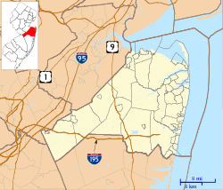
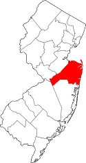
 Spring Mill, New Jersey Location of Spring Mill in Monmouth County Inset: Location of county within the state of New Jersey  Spring Mill, New Jersey Spring Mill, New Jersey (New Jersey)  Spring Mill, New Jersey Spring Mill, New Jersey (the US) | |
| Coordinates: 40°10′27″N 74°36′10″W / 40.17417°N 74.60278°WCoordinates: 40°10′27″N 74°36′10″W / 40.17417°N 74.60278°W | |
| Country |
|
| State |
|
| County | Monmouth |
| Township | Upper Freehold |
| Elevation[1] | 79 ft (24 m) |
| Time zone | UTC-5 (Eastern (EST)) |
| • Summer (DST) | UTC-4 (EDT) |
| GNIS feature ID | 880807[1] |
Spring Mill is an unincorporated community located within Upper Freehold Township in Monmouth County, New Jersey, United States.[2][3] The settlement is located along County Route 524 between Hamilton Township and Allentown on a commercialized segment of the road originally built as New Jersey Route 37. A vestige of the state construction remains along the road through a wide right-of-way and a bridge crossing Doctor's Creek stating that it was constructed by the state in 1940 for State Highway Route 37.[3][4]
References
- 1 2 "Spring Mill". Geographic Names Information System. United States Geological Survey.
- ↑ Locality Search, State of New Jersey. Accessed March 4, 2015.
- 1 2 Google (September 12, 2015). "Aerial view of Spring Mill" (Map). Google Maps. Google. Retrieved September 12, 2015.
- ↑ General Highway Map of Monmouth County, New Jersey (Map). 1962. Retrieved September 12, 2015.
This article is issued from
Wikipedia.
The text is licensed under Creative Commons - Attribution - Sharealike.
Additional terms may apply for the media files.
