Smocks Corner, New Jersey
| Smocks Corner, New Jersey | |
|---|---|
| Unincorporated community | |
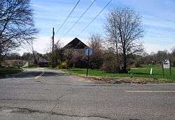 Corner of Pleasant Valley Road and Conover Road | |
 Smocks Corner, New Jersey Location of Smocks Corner in Monmouth County Inset: Location of county within the state of New Jersey  Smocks Corner, New Jersey Smocks Corner, New Jersey (New Jersey)  Smocks Corner, New Jersey Smocks Corner, New Jersey (the US) | |
| Coordinates: 40°21′23″N 74°14′09″W / 40.35639°N 74.23583°WCoordinates: 40°21′23″N 74°14′09″W / 40.35639°N 74.23583°W | |
| Country |
|
| State |
|
| County | Monmouth |
| Township | Marlboro |
| Elevation[1] | 171 ft (52 m) |
| Time zone | UTC-5 (Eastern (EST)) |
| • Summer (DST) | UTC-4 (EDT) |
| GNIS feature ID | 880669[1] |
Smocks Corner or Smocks Corners is an unincorporated community located within Marlboro Township in Monmouth County, New Jersey, United States.[2] Located at the intersection of Pleasant Valley Road and Conover Road, the area is mostly residences with some open space and farmland.[3] It was called "Smocks Corner" because the Smock Family had houses in that area, both sides of the street back in the 1700s.
References
- 1 2 "Smocks Corners". Geographic Names Information System. United States Geological Survey.
- ↑ Locality Search, State of New Jersey. Accessed March 4, 2015.
- ↑ Google (April 19, 2015). "Aerial view of Smocks Corner, New Jersey" (Map). Google Maps. Google. Retrieved April 19, 2015.

This article is issued from
Wikipedia.
The text is licensed under Creative Commons - Attribution - Sharealike.
Additional terms may apply for the media files.