Millhurst, New Jersey
| Millhurst, New Jersey | |
|---|---|
| Unincorporated community | |
 Former Millhurst Mill | |
 Millhurst, New Jersey Location of Millhurst in Monmouth County Inset: Location of county within the state of New Jersey  Millhurst, New Jersey Millhurst, New Jersey (New Jersey)  Millhurst, New Jersey Millhurst, New Jersey (the US) | |
| Coordinates: 40°15′13″N 74°20′30″W / 40.25361°N 74.34167°WCoordinates: 40°15′13″N 74°20′30″W / 40.25361°N 74.34167°W | |
| Country |
|
| State |
|
| County | Monmouth |
| Township | Manalapan |
| Elevation[1] | 144 ft (44 m) |
| Time zone | UTC-5 (Eastern (EST)) |
| • Summer (DST) | UTC-4 (EDT) |
| Area code(s) | 732/848 |
| GNIS feature ID | 878379[1] |
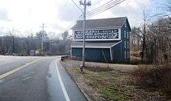
Millhurst is an unincorporated community located within Manalapan Township in Monmouth County, New Jersey, United States.[2] Route 33 and County Route 527 (Sweetmans Lane) pass through the center of Millhurst. Much of the area consists of businesses along the aforementioned arterial roads with the Millhurst Mill at the CR 527 crossing of Manalapan Brook.[3] The mill is a former grist mill built in the 1700s, rebuilt in the 1800s as a more efficient mill, and turned into a family business by Bernard Hochberg in 1925.[4]
References
- 1 2 "Millhurst". Geographic Names Information System. United States Geological Survey.
- ↑ Locality Search, State of New Jersey. Accessed February 27, 2015.
- ↑ Google (March 3, 2016). "Aerial view of Millhurst" (Map). Google Maps. Google. Retrieved March 3, 2016.
- ↑ Celano, Clare Marie (May 28, 2015). "Businesses keep it in the family". News Transcript. Retrieved March 3, 2016.

This article is issued from
Wikipedia.
The text is licensed under Creative Commons - Attribution - Sharealike.
Additional terms may apply for the media files.