Stone Church, New Jersey
| Stone Church, New Jersey | |
|---|---|
| Unincorporated community | |
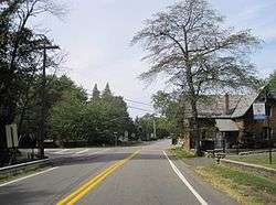 Center of Stone Church, the All Saint's Memorial Church is on the right | |
 Stone Church, New Jersey Location of Stone Church in Monmouth County Inset: Location of county within the state of New Jersey  Stone Church, New Jersey Stone Church, New Jersey (New Jersey)  Stone Church, New Jersey Stone Church, New Jersey (the US) | |
| Coordinates: 40°23′53″N 74°01′11″W / 40.39806°N 74.01972°WCoordinates: 40°23′53″N 74°01′11″W / 40.39806°N 74.01972°W | |
| Country |
|
| State |
|
| County | Monmouth |
| Township | Middletown |
| Elevation[1] | 56 ft (17 m) |
| Time zone | UTC-5 (Eastern (EST)) |
| • Summer (DST) | UTC-4 (EDT) |
| GNIS feature ID | 883574[1] |
Stone Church is an unincorporated community located in Middletown Township in Monmouth County, New Jersey, United States, within the census-designated place of Navesink.[2][3] The settlement is located at the intersection of Valley Road and Locust Avenue (County Route 8A), Navesink Avenue (CR 8B), and Monmouth Avenue. In the center of the community, the historic All Saint's Memorial Episcopal Church built in 1864 sits at the main intersection. The remainder of the area consists of single-family houses and forests on the slopes of nearby Mount Mitchill.[3]
References
- 1 2 "Stone Church". Geographic Names Information System. United States Geological Survey.
- ↑ Locality Search, State of New Jersey. Accessed March 4, 2015.
- 1 2 Google (March 4, 2015). "Stone Church, Monmouth County, New Jersey" (Map). Google Maps. Google. Retrieved March 4, 2015.

This article is issued from
Wikipedia.
The text is licensed under Creative Commons - Attribution - Sharealike.
Additional terms may apply for the media files.