Low Moor, New Jersey
| Low Moor, New Jersey | |
|---|---|
| Unincorporated community | |
 | |
 Low Moor, New Jersey Location of Low Moor in Monmouth County Inset: Location of county within the state of New Jersey  Low Moor, New Jersey Low Moor, New Jersey (New Jersey)  Low Moor, New Jersey Low Moor, New Jersey (the US) | |
| Coordinates: 40°20′59″N 73°58′24″W / 40.34972°N 73.97333°WCoordinates: 40°20′59″N 73°58′24″W / 40.34972°N 73.97333°W | |
| Country |
|
| State |
|
| County | Monmouth |
| Borough | Sea Bright |
| Elevation[1] | 10 ft (3 m) |
| GNIS feature ID | 882498[1] |
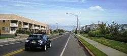
Low Moor is an unincorporated community located within Sea Bright in Monmouth County, New Jersey, United States.[2] It is located at the southern end of the borough at the border with Monmouth Beach. The area consists of single-family homes, condominiums, marinas on the Shrewsbury River side of the peninsula, and public beaches on the Atlantic Ocean side. New Jersey Route 36 (Ocean Avenue) is the main road that runs north and south through the area.[3] The Sea Bright–Monmouth Beach Seawall is parallel to the road.
References
- 1 2 "Low Moor". Geographic Names Information System. United States Geological Survey.
- ↑ Locality Search, State of New Jersey. Accessed February 26, 2015.
- ↑ Google (October 3, 2015). "Aerial view of Low Moor" (Map). Google Maps. Google. Retrieved October 3, 2015.

This article is issued from
Wikipedia.
The text is licensed under Creative Commons - Attribution - Sharealike.
Additional terms may apply for the media files.