Haram, Norway
| Haram kommune | |||
|---|---|---|---|
| Municipality | |||
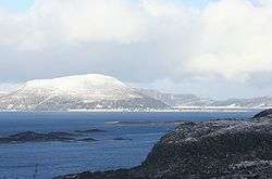 View of Lepsøy | |||
| |||
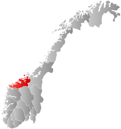
 Haram within Møre og Romsdal | |||
| Coordinates: 62°34′03″N 06°22′20″E / 62.56750°N 6.37222°ECoordinates: 62°34′03″N 06°22′20″E / 62.56750°N 6.37222°E | |||
| Country | Norway | ||
| County | Møre og Romsdal | ||
| District | Sunnmøre | ||
| Administrative centre | Brattvåg | ||
| Government | |||
| • Mayor (2015) | Vebjørn Krogsæter (Sp) | ||
| Area | |||
| • Total | 261.14 km2 (100.83 sq mi) | ||
| • Land | 254.30 km2 (98.19 sq mi) | ||
| • Water | 6.84 km2 (2.64 sq mi) | ||
| Area rank | #294 in Norway | ||
| Population (2017) | |||
| • Total | 9,312 | ||
| • Rank | #122 in Norway | ||
| • Density | 36.6/km2 (95/sq mi) | ||
| • Change (10 years) | 8.2% | ||
| Demonym(s) |
Harams-mann Harams-kvinne[1] | ||
| Time zone | UTC+01:00 (CET) | ||
| • Summer (DST) | UTC+02:00 (CEST) | ||
| ISO 3166 code | NO-1534 | ||
| Official language form | Nynorsk | ||
| Website |
www | ||
Haram is a municipality in Møre og Romsdal county, Norway. It is part of the Sunnmøre region. The administrative center is Brattvåg, the industrial center of Sunnmøre. Other important villages in the municipality include Austnes, Eidsvik, Helle, Longva, Hildrestranda, Søvik, Tennfjord, and Vatne.
Brattvåg IL is a sports club based in the municipality. Tennfjord Mannskor is a male choir from the village of Tennfjord. The Ulla Lighthouse and Hellevik Lighthouse are both located in the northwestern part of the municipality.
The 261-square-kilometre (101 sq mi) municipality is the 294th largest by area out of the 422 municipalities in Norway. Haram is the 122nd most populous municipality in Norway with a population of 9,312. The municipality's population density is 36.6 inhabitants per square kilometre (95/sq mi) and its population has increased by 8.2% over the last decade.[2]
General information

Haram was established as a municipality on 1 January 1838 (see formannskapsdistrikt). The western island district of Roald was separated from Haram on 1 January 1890 to form a municipality of its own. This left 1,956 people left in Haram. On 1 January 1965, the eastern district of Haram, including the Myklebost area on Harøya island and some smaller islands to the west of there (population: 287), was separated from Haram Municipality and merged into the neighboring Sandøy Municipality to the east. Also on that date, most of the municipality of Vatne (population: 2,260) to the southeast of Haram Municipality was merged into Haram Municipality. There was one other municipal boundary change on that date in 1965: the Søvik area in Borgund Municipality (population: 1,191) to the south of Haram Municipality were merged with Haram. This boundary change created a much larger municipality of Haram.[3]
In June 2017, the Parliament of Norway voted to merge Haram with the neighboring municipalities of Skodje, Ørskog, Sandøy, and Ålesund to form a new, large municipality of Ålesund.[4]
Name
The municipality (originally the parish) is named after the old Haram farm (Old Norse: Harhamarr), since the first church (Haram Church) was built there. The meaning of the first element is unknown and the last element is hamarr which means "rocky hill". Before 1889, the name was written Harham.[5]
Coat of arms
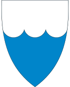
The coat of arms is from modern times. It was granted on 7 August 1987. The arms show three waves in blue with a silver background, symbolizing the importance of the sea in this island municipality.[6]
Dialect
The dialect of the district was well known for its practice of H-dropping and the old and traditional pronunciation of the name of the municipality was [a:ram].
Churches
The Church of Norway has five parishes (sokn) within the municipality of Haram. It is part of the Nordre Sunnmøre deanery in the Diocese of Møre.
| Parish (Sokn) | Church Name | Location of the Church | Year Built |
|---|---|---|---|
| Haram | Haram Church | Austnes | 1838 |
| Lepsøy Chapel | Lepsøya | 1896 | |
| Fjørtoft | Fjørtoft Church | Fjørtofta | 1878 |
| Vatne | Vatne Church | Vatne | 1868 |
| Hamnsund | Hamnsund Church | just south of Søvik | 1875 |
| Brattvåg | Brattvåg Church | Brattvåg | 1977 |
| Hildre Church | Hildrestranda | 1905 |
Geography
The municipality of Haram includes many islands including Bjørnøya, Fjørtofta, Haramsøya, Løvsøya, Skuløya, and Terøya. The islands of Bjørnøya and Terøya are connected to the mainland via causeways. The islands of Haramsøya and Skuløya are connected with the Ullasund Bridge. The rest of the islands have ferry connections to the mainland. The Haramsfjorden, Vatnefjorden, and Romsdal Fjord all flow through the municipality.
The municipality shares land borders with Vestnes Municipality to the east and Skodje Municipality to the south. The rest of the municipality is surrounded by sea. The municipality also borders (by sea) Sandøy Municipality and Midsund Municipality to the northeast, Ålesund Municipality to the south, and Giske Municipality to the west.
Government
All municipalities in Norway, including Haram, are responsible for primary education (through 10th grade), outpatient health services, senior citizen services, unemployment and other social services, zoning, economic development, and municipal roads. The municipality is governed by a municipal council of elected representatives, which in turn elect a mayor.
Municipal council
The municipal council (Kommunestyre) of Haram is made up of 27 representatives that are elected to four year terms. Currently, the party breakdown is as follows:[7]
| Party Name | Name in Norwegian | Number of representatives | |
|---|---|---|---|
| Labour Party | Arbeiderpartiet | 5 | |
| Progress Party | Framstegspartiet | 6 | |
| Conservative Party | Høgre | 5 | |
| Christian Democratic Party | Kristelig Folkeparti | 3 | |
| Green Party | Miljøpartiet Dei Grøne | 1 | |
| Centre Party | Senterpartiet | 6 | |
| Liberal Party | Venstre | 1 | |
| Total number of members: | 27 | ||
Media gallery
 Hildre Church near Brattvåg
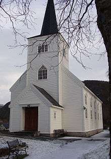 Hamnsund Church near Søvik
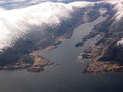 View of Brattvåg village
 View of Lepsøya island
References
- ↑ "Navn på steder og personer: Innbyggjarnamn" (in Norwegian). Språkrådet. Retrieved 2015-12-01.
- ↑ Statistisk sentralbyrå (2017). "Table: 06913: Population 1 January and population changes during the calendar year (M)" (in Norwegian). Retrieved 2017-10-14.
- ↑ Jukvam, Dag (1999). "Historisk oversikt over endringer i kommune- og fylkesinndelingen" (PDF) (in Norwegian). Statistisk sentralbyrå.
- ↑ "Om nye Ålesund: Bakgrunn" (in Norwegian). Nye Ålesund kommune. Retrieved 2017-10-14.
- ↑ Rygh, Oluf (1908). Norske gaardnavne: Romsdals amt (in Norwegian) (13 ed.). Kristiania, Norge: W. C. Fabritius & sønners bogtrikkeri. p. 206.
- ↑ "Kommunevåpenet - "Bølgje II"" (in Norwegian). Haram kommune. Retrieved 2010-10-21.
- ↑ "Table: 04813: Members of the local councils, by party/electoral list at the Municipal Council election (M)" (in Norwegian). Statistics Norway. 2015.
| Wikimedia Commons has media related to Haram. |
External links
- Municipal fact sheet from Statistics Norway (in Norwegian)
