Ulstein
| Ulstein kommune | |||
|---|---|---|---|
| Municipality | |||
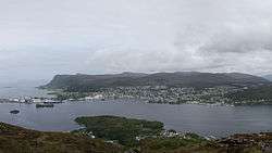 View of Ulsteinvik | |||
| |||
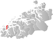 Ulstein within Møre og Romsdal | |||
| Coordinates: 62°21′23″N 05°51′14″E / 62.35639°N 5.85389°ECoordinates: 62°21′23″N 05°51′14″E / 62.35639°N 5.85389°E | |||
| Country | Norway | ||
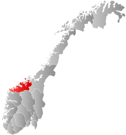
| County | Møre og Romsdal | ||
| District | Sunnmøre | ||
| Administrative centre | Ulsteinvik | ||
| Government | |||
| • Mayor (2015) | Knut Erik Engh (FrP) | ||
| Area | |||
| • Total | 97.19 km2 (37.53 sq mi) | ||
| • Land | 94.87 km2 (36.63 sq mi) | ||
| • Water | 2.32 km2 (0.90 sq mi) | ||
| Area rank | #383 in Norway | ||
| Population (2017) | |||
| • Total | 8,457 | ||
| • Rank | #130 in Norway | ||
| • Density | 89.1/km2 (231/sq mi) | ||
| • Change (10 years) | 23.6% | ||
| Demonym(s) | Ulsteining[1] | ||
| Time zone | UTC+01:00 (CET) | ||
| • Summer (DST) | UTC+02:00 (CEST) | ||
| ISO 3166 code | NO-1516 | ||
| Official language form | Nynorsk | ||
| Website |
www | ||
Ulstein is a municipality in Møre og Romsdal county, Norway. It is part of the Sunnmøre region. The commercial and administrative centre of Ulstein is the town of Ulsteinvik. The municipality occupies the western half of the island of Hareidlandet, as well as about 30 smaller islands, four of which are populated.
Ulstein is connected to the mainland of Norway by the Eiksund Bridge (to the island of Eika) and then the Eiksund Tunnel to Ørsta Municipality. The Grasøyane Lighthouse is located on a small island in the northwestern part of Ulstein Municipality.
The 97-square-kilometre (37 sq mi) municipality is the 383rd largest by area out of the 422 municipalities in Norway. Ulstein is the 130th most populous municipality in Norway with a population of 8,457. The municipality's population density is 89.1 inhabitants per square kilometre (231/sq mi) and its population has increased by 23.6% over the last decade.[2]
General information

The municipality of Ulstein (originally Ulfsteen) was established as a municipality on 1 January 1838 (see formannskapsdistrikt). It originally included most of the island of Hareidlandet (except the Eiksund area) and the Vartdal area southeast of the Vartdalsfjorden on the mainland. On 1 January 1895, the area southeast of the Vartdalsfjorden was separated from Ulstein Municipality to become the new municipality of Vartdalsstranden. This left Ulstein with 2,996 residents. Then on 1 January 1917, the eastern half of the island of Hareidlandet was separated from Ulstein to form the new Hareid Municipality. This left 2,336 residents in Ulstein. On 1 January 1964, the island of Eika, the village of Eiksund, and the surrounding area (population: 222) were transferred from Herøy Municipality to Ulstein Municipality.[3]
Name
The municipality (originally the parish) is named after the old Ulstein farm (Old Norse: Ulfsteinn), since the first church (Ulstein Church) was built there. The first element is ulfr which means "wolf" and the last element is steinn which means "stone mountain" (probably referring to a hill behind the farm).
Before 1879, the name was written Ulfsten or Ulfsteen, then between 1879-1888 it was spelled Ulvsten, and since 1889, it has been spelled Ulstein.[4]
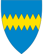
Coat-of-arms
The coat-of-arms is from modern times. They were granted on 30 May 1986. The arms show a bar described as wolf-toothed, which makes the bar a canting since ulf means wolf and the municipality is named after the Ulva river. The blue colour represents the sea, the gold the wheat.[5]
Churches
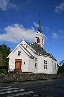
The Church of Norway has one parish (sokn) within the municipality of Ulstein. It is part of the Søre Sunnmøre deanery in the Diocese of Møre.
| Parish (Sokn) | Church Name | Location of the Church | Year Built |
|---|---|---|---|
| Ulstein | Ulstein Church | Ulsteinvik | 1849 |
Communities
There are several villages throughout the municipality. The two identified by Statistics Norway as "urban communities", meaning they have a population density of at least 300 inhabitants per square kilometre (780/sq mi) in their core, and a total population above 200, are the town of Ulsteinvik and the village of Haddal. Other settlements include Flø, Eiksund, Ringstad, Sundgot, Hasund, Varleite. The island of Dimnøya is just outside Ulsteinvik, and there are many residents there. There are also several small populated islands surrounding the main island of Hareidlandet: Eika, Vattøya, and Hatløya.
Government
All municipalities in Norway, including Ulstein, are responsible for primary education (through 10th grade), outpatient health services, senior citizen services, unemployment and other social services, zoning, economic development, and municipal roads. The municipality is governed by a municipal council of elected representatives, which in turn elect a mayor.
Municipal council
The municipal council (Kommunestyre) of Ulstein is made up of 25 representatives that are elected to four year terms. Currently, the party breakdown is as follows:[6]
| Party Name | Name in Norwegian | Number of representatives | |
|---|---|---|---|
| Labour Party | Arbeiderpartiet | 5 | |
| Progress Party | Framstegspartiet | 6 | |
| Conservative Party | Høgre | 5 | |
| Christian Democratic Party | Kristelig Folkeparti | 3 | |
| Centre Party | Senterpartiet | 2 | |
| Socialist Left Party | Sosialistisk Venstreparti | 1 | |
| Liberal Party | Venstre | 3 | |
| Total number of members: | 25 | ||
Industry

Maritime Cluster
The Headquarters of the Ulstein Group, Rolls-Royce Marine, and Kleven Verft are located in Ulstein. The maritime industry is renowned for its creativity in the ship industry, which currently employs more than 1,000 people in Ulstein.
Ulstein is known as a central community in the maritime cluster that has been created within the Sunnmøre region, Norway. Large shipyards and ship design companies are situated in Ulsteinvik. Technological innovation has played an import role in the recent history of the town. For example, the Ulstein Group has designed a new hull shape with an inverted bow called the Ulstein Group's X-Bow, examples of which are regularly docked in Ulsteinvik, outside the drydocks of Ulstein Verft.
References
- ↑ "Navn på steder og personer: Innbyggjarnamn" (in Norwegian). Språkrådet. Retrieved 2015-12-01.
- ↑ Statistisk sentralbyrå (2017). "Table: 06913: Population 1 January and population changes during the calendar year (M)" (in Norwegian). Retrieved 2017-10-19.
- ↑ Jukvam, Dag (1999). "Historisk oversikt over endringer i kommune- og fylkesinndelingen" (PDF) (in Norwegian). Statistisk sentralbyrå.
- ↑ Rygh, Oluf (1908). Norske gaardnavne: Romsdals amt (in Norwegian) (13 ed.). Kristiania, Norge: W. C. Fabritius & sønners bogtrikkeri. p. 51.
- ↑ Norske Kommunevåpen (1990). "Nye kommunevåbener i Norden". Retrieved 25 October 2008.
- ↑ "Table: 04813: Members of the local councils, by party/electoral list at the Municipal Council election (M)" (in Norwegian). Statistics Norway. 2015.
| Wikimedia Commons has media related to Ulstein. |
| Wikivoyage has a travel guide for Møre og Romsdal. |
External links
- Municipal fact sheet from Statistics Norway (in Norwegian)
- Ulstein Group
- Ulstein Kommune (in Norwegian)