Ørsta
| Ørsta kommune | |||
|---|---|---|---|
| Municipality | |||
| |||
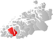 Ørsta within Møre og Romsdal | |||
| Coordinates: 62°12′01″N 06°07′56″E / 62.20028°N 6.13222°ECoordinates: 62°12′01″N 06°07′56″E / 62.20028°N 6.13222°E | |||
| Country | Norway | ||
| County | Møre og Romsdal | ||
| District | Sunnmøre | ||
| Administrative centre | Ørsta | ||
| Government | |||
| • Mayor (2015) | Stein Aam (Sp) | ||
| Area | |||
| • Total | 804.43 km2 (310.59 sq mi) | ||
| • Land | 785.03 km2 (303.10 sq mi) | ||
| • Water | 19.40 km2 (7.49 sq mi) | ||
| Area rank | #138 in Norway | ||
| Population (2017) | |||
| • Total | 10,744 | ||
| • Rank | #108 in Norway | ||
| • Density | 13.7/km2 (35/sq mi) | ||
| • Change (10 years) | 5.7% | ||
| Demonym(s) | Ørsting[1] | ||
| Time zone | UTC+01:00 (CET) | ||
| • Summer (DST) | UTC+02:00 (CEST) | ||
| ISO 3166 code | NO-1520 | ||
| Official language form | Nynorsk | ||
| Website |
www | ||

![]()
The 804-square-kilometre (310 sq mi) municipality is the 138th largest by area out of the 422 municipalities in Norway. Ørsta is the 108th most populous municipality in Norway with a population of 10,744. The municipality's population density is 13.7 inhabitants per square kilometre (35/sq mi) and its population has increased by 5.7% over the last decade.[2]
General information
The municipality of Ørsta was established on 1 August 1883 when it was separated from Volda Municipality. The initial population was 2,070. On 1 January 1893, the Ytrestølen farm (population: 13) was transferred from Ørsta to Volda. During the 1960s, there were many municipal mergers across Norway due to the work of the Schei Committee. On 1 January 1964, the municipalities of Hjørundfjord and Vartdal were also merged with Ørsta. The new, larger municipality of Ørsta had a population of 9,252.[3]
Name
The municipality is named after the Ørstafjorden (Old Norse: Œrstr). The meaning of the name is unknown. Before 1918, the name was written Ørsten.[4]
Coat-of-arms
The coat-of-arms is from modern times. They were granted on 13 July 1984. The arms consist of three silver diamonds on a blue background. The three diamonds represent the mountains reflecting in the waters of the fjord.[5]
Museums
The Brudavoll Farm, part of the Sunnmøre Museum Foundation, is located about 5 km (3.1 mi) from the center of Ørsta.[6]
Churches
The Church of Norway has four parishes (sokn) within the municipality of Ørsta. It is part of the Søre Sunnmøre deanery in the Diocese of Møre.[7]
| Parish (Sokn) | Church Name | Location of the Church | Year Built |
|---|---|---|---|
| Ørsta | Ørsta Church | Ørsta | 1864 |
| Vartdal | Vartdal Church | Nordre Vartdal | 1876 |
| Hjørundfjord | Hjørundfjord Church | Sæbø | 1880 |
| Storfjorden | Bjørke Church | Bjørke | 1919 |
Geography

Of the total area, 48% (386 square kilometres or 149 square miles) of the municipality is at an altitude of 600 metres (2,000 ft) or more above sea level. Apart from the mountains, Ørsta's dominant geographical feature is fjords: Storfjorden in the north, Vartdalsfjorden, Ørstafjorden in the west, and Hjørundfjorden in the east. Only in the south is it connected by land to neighbouring Volda Municipality. Otherwise, it borders the municipalities of Sula in the north, Hareid and Ulstein (by sea only) in the west, Sykkylven to the northeast, Stranda to the southeast and Sogn og Fjordane county to the south-southeast.

The municipality is also the heartland of the Sunnmørsalpene mountains, a particularly rugged and wild area of mountains in the southern part of Møre og Romsdal county. Prolific peaks include Slogen at 1,564 metres (5,131 ft), Skårasalen at 1,542 metres (5,059 ft), Kolåstinden at 1,432 metres (4,698 ft), Ramoen at 1,419 metres (4,656 ft), Saudehornet at 1,303 metres (4,275 ft), and Romedalstinden at 1,295 metres (4,249 ft). Other mountains include Hornindalsrokken, Kvitegga, and Jakta.
Government
All municipalities in Norway, including Ørsta, are responsible for primary education (through 10th grade), outpatient health services, senior citizen services, unemployment and other social services, zoning, economic development, and municipal roads. The municipality is governed by a municipal council of elected representatives, which in turn elect a mayor.
Municipal council
The municipal council (Kommunestyre) of Ørsta is made up of 33 representatives that are elected to four year terms. Currently, the party breakdown is as follows:[8]
| Party Name | Name in Norwegian | Number of representatives | |
|---|---|---|---|
| Labour Party | Arbeiderpartiet | 5 | |
| Progress Party | Framstegspartiet | 5 | |
| Conservative Party | Høgre | 7 | |
| Christian Democratic Party | Kristelig Folkeparti | 4 | |
| Green Party | Miljøpartiet Dei Grøne | 1 | |
| Centre Party | Senterpartiet | 8 | |
| Socialist Left Party | Sosialistisk Venstreparti | 1 | |
| Liberal Party | Venstre | 2 | |
| Total number of members: | 33 | ||
Economy
Important sectors are mechanical industry and furniture manufacturing, agriculture, commercial fishing, and aquaculture. The first two are predominant in the village of Ørsta while agriculture dominates in adjacent valleys like the Follestaddalen, Åmdalen, and Bondalen valleys. On the other hand, the northern part of the municipality has strong maritime traditions, with Vartdal being the home of one of the largest factory trawler fleets in Norway.
Transportation
These include Ørsta-Volda Airport, Hovden at Hovdebygda which is the regional airport for people living in the municipalities Ørsta, Volda, Vanylven, Sande, Ulstein, Hareid and Herøy, and European Route E39 which transects the municipality in a north–south direction. Ørsta is linked to Sula and Sykkylven by ferry on its northernmost extreme Festøy. It is also linked to Ulstein Municipality by the Eiksund Tunnel, an undersea tunnel that opened on 23 February 2008 that is, currently, the world's deepest at 287 metres (942 ft) below the sea surface.
Notable residents
- Ivar Aasen, Norwegian philologist and lexicographer, creator of the Nynorsk language
- Helge Barstad, politician
- Anders Hovden, Norwegian priest and poet, creator of psalms like Fagert er landet.
References
- ↑ "Navn på steder og personer: Innbyggjarnamn" (in Norwegian). Språkrådet. Retrieved 2015-12-01.
- ↑ Statistisk sentralbyrå (2017). "Table: 06913: Population 1 January and population changes during the calendar year (M)" (in Norwegian). Retrieved 2017-10-20.
- ↑ Jukvam, Dag (1999). "Historisk oversikt over endringer i kommune- og fylkesinndelingen" (PDF) (in Norwegian). Statistisk sentralbyrå.
- ↑ Rygh, Oluf (1908). Norske gaardnavne: Romsdals amt (in Norwegian) (13 ed.). Kristiania, Norge: W. C. Fabritius & sønners bogtrikkeri. p. 86.
- ↑ Norske Kommunevåpen (1990). "Nye kommunevåbener i Norden". Retrieved 19 October 2008.
- ↑ "Brudavolltunet". Fjord Norway. Retrieved January 24, 2018.
- ↑ "Kyrkjelydane i Ørsta" (in Norwegian). Den Norske Kyrkja. Retrieved 2010-09-23.
- ↑ "Table: 04813: Members of the local councils, by party/electoral list at the Municipal Council election (M)" (in Norwegian). Statistics Norway. 2015.
External links
| Wikimedia Commons has media related to Ørsta. |
- Municipal fact sheet from Statistics Norway (in Norwegian)
- Official site of Ørsta Tourist Board
- Ørsta kommune (in Norwegian)