Sandøy
| Sandøy kommune | |||
|---|---|---|---|
| Municipality | |||
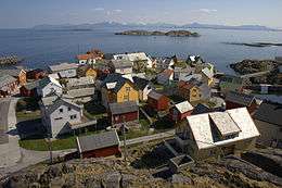 View of the village of Ona | |||
| |||
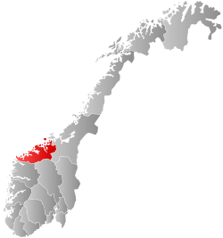
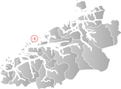 Sandøy within Møre og Romsdal | |||
| Coordinates: 62°45′40″N 06°27′5″E / 62.76111°N 6.45139°ECoordinates: 62°45′40″N 06°27′5″E / 62.76111°N 6.45139°E | |||
| Country | Norway | ||
| County | Møre og Romsdal | ||
| District | Romsdal | ||
| Administrative centre | Steinshamn | ||
| Government | |||
| • Mayor (2015) | Oddvar Myklebust (Ap) | ||
| Area | |||
| • Total | 21.43 km2 (8.27 sq mi) | ||
| • Land | 21.36 km2 (8.25 sq mi) | ||
| • Water | 0.07 km2 (0.03 sq mi) | ||
| Area rank | #416 in Norway | ||
| Population (2017) | |||
| • Total | 1,249 | ||
| • Rank | #375 in Norway | ||
| • Density | 58.3/km2 (151/sq mi) | ||
| • Change (10 years) | -2.4% | ||
| Demonym(s) | Sandøying[1] | ||
| Time zone | UTC+01:00 (CET) | ||
| • Summer (DST) | UTC+02:00 (CEST) | ||
| ISO 3166 code | NO-1546 | ||
| Official language form | Nynorsk | ||
| Website |
www | ||

Sandøy is an island municipality in Møre og Romsdal county, Norway. It is part of the Romsdal region. The administrative centre is the village of Steinshamn. Other villages include Ona and Myklebost. The municipality is spread out over many islands in the mouth of Romsdal Fjord. The Flatflesa Lighthouse and Ona Lighthouse protect the boats traveling around the municipality. The Nordøy Fixed Link project is scheduled to be constructed from 2018 until 2023 and it will include three undersea tunnels and several bridges that will connect the main islands of Sandøy Municipality and the islands of Haram Municipality to the mainland.[2]
The 21-square-kilometre (8.1 sq mi) municipality is the 416th largest by area out of the 422 municipalities in Norway. Sandøy is the 375th most populous municipality in Norway with a population of 1,246. The municipality's population density is 58.3 inhabitants per square kilometre (151/sq mi) and its population has decreased by 2.4% over the last decade.[3]
General information


The municipality of Sandø i Romsdal was established on 1 January 1867 when it was separated from Akerø Municipality. The initial population was 601. The spelling of the name was later changed to Sandøy. On 1 January 1965, the Myklebost area on Harøya island and some smaller islands to the west (population: 287) were transferred from Haram Municipality to Sandøy Municipality.[4]
On 1 January 2020, the municipality of Sandøy is scheduled to be merged with Haram Municipality, Ørskog Municipality, Skodje Municipality, and Ålesund Municipality to form one large municipality of Ålesund.[5]
Name
The municipality (originally the parish) is named after the farm and the small island, Sandøya (Old Norse: Sandøy), since the first church (Sandøy Church) was built there. The first element is sandr which means "sand" and the last element is øy which means "island". The name was historically spelled Sandø or Sandøen.[6]
Coat-of-arms
The coat-of-arms is from modern times. They were granted on 12 December 1986. The arms show the light beams from the Ona Lighthouse, since lighthouses play an important role in the safety in the municipality, which consists of 871 islands and skerries.[7]
Churches
The Church of Norway has one parish (sokn) within the municipality of Sandøy. It is part of the Molde arch-deanery in the Diocese of Møre.
| Parish (Sokn) | Church Name | Location of the Church | Year Built |
|---|---|---|---|
| Sandøy | Sandøy Church | Sandøya | 1812 |
| Harøy Church | Harøya | 1934 |
Geography
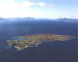
Sandøy is an island municipality. Sandøy consists of 871 islands, but only five are regularly inhabited. The main inhabited islands are Harøya, Sandøya, Finnøya, Ona, and Orta. Ona is the most famous of the islands and is a popular tourist destination due to its history and the Ona Lighthouse.
Government
All municipalities in Norway, including Sandøy, are responsible for primary education (through 10th grade), outpatient health services, senior citizen services, unemployment and other social services, zoning, economic development, and municipal roads. The municipality is governed by a municipal council of elected representatives, which in turn elect a mayor.
Municipal council
The municipal council (Kommunestyre) of Sandøy is made up of 19 representatives that are elected to four year terms. Currently, the party breakdown is as follows:[8]
| Party Name | Name in Norwegian | Number of representatives | |
|---|---|---|---|
| Labour Party | Arbeiderpartiet | 10 | |
| Conservative Party | Høgre | 6 | |
| Liberal Party | Venstre | 3 | |
| Total number of members: | 19 | ||
References
- ↑ "Navn på steder og personer: Innbyggjarnamn" (in Norwegian). Språkrådet. Retrieved 2015-12-01.
- ↑ "Fv 659 Nordøyvegen" (in Norwegian). Statens vegvesen. Retrieved 2017-10-19.
- ↑ Statistisk sentralbyrå (2017). "Table: 06913: Population 1 January and population changes during the calendar year (M)" (in Norwegian). Retrieved 2017-10-19.
- ↑ Jukvam, Dag (1999). "Historisk oversikt over endringer i kommune- og fylkesinndelingen" (PDF) (in Norwegian). Statistisk sentralbyrå.
- ↑ "Nye Ålesund" (in Norwegian). Retrieved 2017-10-19.
- ↑ Rygh, Oluf (1908). Norske gaardnavne: Romsdals amt (in Norwegian) (13 ed.). Kristiania, Norge: W. C. Fabritius & sønners bogtrikkeri. p. 311.
- ↑ Norske Kommunevåpen (1990). "Nye kommunevåbener i Norden". Retrieved 19 October 2008.
- ↑ "Table: 04813: Members of the local councils, by party/electoral list at the Municipal Council election (M)" (in Norwegian). Statistics Norway. 2015.
External links


- Municipal fact sheet from Statistics Norway (in Norwegian)