Fræna
| Fræna kommune | |||
|---|---|---|---|
| Municipality | |||
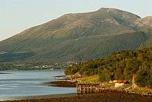
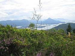 View from Lågheia near Elnesvågen | |||
| |||
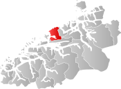 Fræna within Møre og Romsdal | |||
| Coordinates: 62°54′28″N 07°06′30″E / 62.90778°N 7.10833°ECoordinates: 62°54′28″N 07°06′30″E / 62.90778°N 7.10833°E | |||
| Country | Norway | ||
| County | Møre og Romsdal | ||
| District | Romsdal | ||
| Administrative centre | Elnesvågen | ||
| Government | |||
| • Mayor (2015) | Tove Henøen (Sp) | ||
| Area | |||
| • Total | 369.74 km2 (142.76 sq mi) | ||
| • Land | 361.93 km2 (139.74 sq mi) | ||
| • Water | 7.81 km2 (3.02 sq mi) | ||
| Area rank | #250 in Norway | ||
| Population (2017) | |||
| • Total | 9,741 | ||
| • Rank | #116 in Norway | ||
| • Density | 26.9/km2 (70/sq mi) | ||
| • Change (10 years) | 6.7% | ||
| Demonym(s) | Frening[1] | ||
| Time zone | UTC+01:00 (CET) | ||
| • Summer (DST) | UTC+02:00 (CEST) | ||
| ISO 3166 code | NO-1548 | ||
| Official language form | Nynorsk | ||
| Website |
www | ||
Fræna is a municipality in Møre og Romsdal county, Norway. It is part of the region of Romsdal. The municipality is located on the Romsdal peninsula surrounding the Frænfjorden, the eastern shore of the Julsundet strait, and includes most of the Hustadvika area. It also includes the now-abandoned Bjørnsund islands.
The main village and administrative centre in Fræna is Elnesvågen with over 2,300 inhabitants. Moxy Engineering, Hustad Marmor, and Tine Meierier are all factories located in Elnesvågen. Other villages in Fræna include Hustad, Bud, Tornes, Sylte, Malme, and Aureosen. The area is nice for hiking, including the mountains are Heiane/Lågheiane and Jendemsfjellet.
The 370-square-kilometre (140 sq mi) municipality is the 250th largest by area out of the 422 municipalities in Norway. Fræna is the 116th most populous municipality in Norway with a population of 9,741. The municipality's population density is 26.9 inhabitants per square kilometre (70/sq mi) and its population has increased by 6.7% over the last decade.[2]
General information

The municipality of Fræna was established in 1840 when it was separated from the municipality of Akerø. The original municipality was named Vaagø and it surrounded the Frænfjorden. Later the name was changed to Fræna.
On 1 January 1964, Bud Municipality and Hustad Municipality were merged with Fræna to form a new, larger municipality of Fræna.[3]
On 1 January 2020, the neighboring municipalities of Eide and Fræna will be merged into the new municipality of Hustadvika.[4][5]
Name
The municipality is named after the Frænfjorden (Old Norse: Fræni). The meaning of the name is unknown, but it might be derived from frænn which means "bright" or "shiny". Before 1865, the parish and municipality were named Vaagø (and the main church was Vågøy Church, which also was historically spelled Vaagø). From 1865-1918, the name was written Frænen, and since 1918 it has had its current spelling, Fræna.[6]
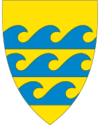
Coat-of-arms
The coat-of-arms is from modern times. They were granted on 15 May 1995. The arms show three blue waves on a gold background. The arms were chosen to symbolize the municipality's connection to the sea.[7]
Churches
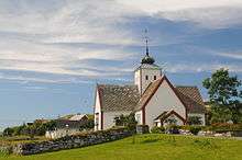
The Church of Norway has four parishes (sokn) within the municipality of Fræna. It is part of the Molde arch-deanery in the Diocese of Møre.
| Parish (Sokn) | Church Name | Location of the Church | Year Built |
|---|---|---|---|
| Bud | Bud Church | Bud | 1717 |
| Hustad | Hustad Church | Hustad | 1874 |
| Myrbostad | Myrbostad Church | Elnesvågen | 1880 |
| Vågøy | Vågøy Church | Vågøya | 1904 |
Geography
The municipality of Fræna sits on the northwestern end of the Romsdal Peninsula. The Norwegian Sea lies to the north, the Harøyfjorden, Julsundet strait, and Aukra Municipality lie to the west, Molde Municipality lies to the south, and Gjemnes Municipality and Eide Municipality lie to the east.
The Frænfjorden cuts into the middle of the municipality. The coastal areas are low and marshy while the interior of the municipality is mountainous. Two of the more notable mountains are Jendemsfjellet and Heiane. The Bjørnsund islands lie off the northwestern coast of Fræna. They are now uninhabited, but the Bjørnsund Lighthouse is still in operation.
Government
All municipalities in Norway, including Fræna, are responsible for primary education (through 10th grade), outpatient health services, senior citizen services, unemployment and other social services, zoning, economic development, and municipal roads. The municipality is governed by a municipal council of elected representatives, which in turn elect a mayor.
Municipal council
The municipal council (Kommunestyre) of Fræna is made up of 31 representatives that are elected to four year terms. Currently, the party breakdown is as follows:[8]
| Party Name | Name in Norwegian | Number of representatives | |
|---|---|---|---|
| Labour Party | Arbeiderpartiet | 6 | |
| Progress Party | Framstegspartiet | 3 | |
| Conservative Party | Høgre | 6 | |
| Christian Democratic Party | Kristelig Folkeparti | 3 | |
| Centre Party | Senterpartiet | 11 | |
| Socialist Left Party | Sosialistisk Venstreparti | 1 | |
| Liberal Party | Venstre | 1 | |
| Total number of members: | 31 | ||
References
- ↑ "Navn på steder og personer: Innbyggjarnamn" (in Norwegian). Språkrådet. Retrieved 2015-12-01.
- ↑ Statistisk sentralbyrå (2017). "Table: 06913: Population 1 January and population changes during the calendar year (M)" (in Norwegian). Retrieved 2017-10-09.
- ↑ Jukvam, Dag (1999). "Historisk oversikt over endringer i kommune- og fylkesinndelingen" (PDF) (in Norwegian). Statistisk sentralbyrå.
- ↑ "Hustadvika kommune endelig vedtatt!" (in Norwegian). Fræna kommune. Retrieved 2017-10-09.
- ↑ "Nye Eide og Fræna kommune" (in Norwegian). Retrieved 2017-10-09.
- ↑ Rygh, Oluf (1908). Norske gaardnavne: Romsdals amt (in Norwegian) (13 ed.). Kristiania, Norge: W. C. Fabritius & sønners bogtrikkeri. p. 290.
- ↑ "Vedtekter for bruk av kommunevåpen Fræna kommune" (in Norwegian). Retrieved 2008-10-18.
- ↑ "Table: 04813: Members of the local councils, by party/electoral list at the Municipal Council election (M)" (in Norwegian). Statistics Norway. 2015.
External links
| Wikimedia Commons has media related to Fræna. |
| Wikivoyage has a travel guide for Møre og Romsdal. |
- Municipal fact sheet from Statistics Norway (in Norwegian)
- http://www.frena.net (in Norwegian) - Homepage edited by a local enthusiast
- Romsdals Budstikke newspaper (in Norwegian)