Sunndal
| Sunndal kommune | |||
|---|---|---|---|
| Municipality | |||
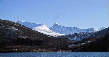
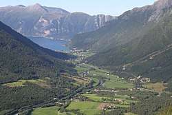 View of the Øksendal valley | |||
| |||
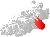 Sunndal within Møre og Romsdal | |||
| Coordinates: 62°36′46″N 08°38′03″E / 62.61278°N 8.63417°ECoordinates: 62°36′46″N 08°38′03″E / 62.61278°N 8.63417°E | |||
| Country | Norway | ||
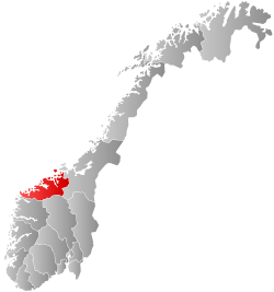
| County | Møre og Romsdal | ||
| District | Nordmøre | ||
| Administrative centre | Sunndalsøra | ||
| Government | |||
| • Mayor (2009) | Ståle Refstie (Ap) | ||
| Area | |||
| • Total | 1,713.44 km2 (661.56 sq mi) | ||
| • Land | 1,647.93 km2 (636.27 sq mi) | ||
| • Water | 65.51 km2 (25.29 sq mi) | ||
| Area rank | #40 in Norway | ||
| Population (2017) | |||
| • Total | 7,126 | ||
| • Rank | #148 in Norway | ||
| • Density | 4.3/km2 (11/sq mi) | ||
| • Change (10 years) | -2.8% | ||
| Demonym(s) | Sunndaling[1] | ||
| Time zone | UTC+01:00 (CET) | ||
| • Summer (DST) | UTC+02:00 (CEST) | ||
| ISO 3166 code | NO-1563 | ||
| Official language form | Neutral | ||
| Website |
www | ||

![]()
The 1,713-square-kilometre (661 sq mi) municipality is the 40th largest by area out of the 422 municipalities in Norway and it is the largest in Møre og Romsdal county. Sunndal is the 148th most populous municipality in Norway with a population of 7,126. The municipality's population density is 4.3 inhabitants per square kilometre (11/sq mi) and its population has decreased by 2.8% over the last decade.[2]
General information
The parish of Sunndal was established as a municipality on 1 January 1838 (see formannskapsdistrikt). The northern part of the municipality was separated in 1854 as the new municipality of Øksendal. On 1 January 1960, Ålvundeid (which was originally a part of Øksendal) and Øksendal municipalities were merged back into Sunndal municipality. On 1 January 1965, the Ålvund-Ålvundfjord area of Stangvik municipality (population: 508) was transferred to Sunndal.[3]
Name
The Old Norse form of the name was Sunndalr. The first element is sunnr which means "southern" and the last element is dalr which means "valley" or "dale". Before 1870, the name was written Sunddalen (or Sunndalen); during the period from 1870–1917, it was spelled Sundalen; and since 1918, it has been spelled Sunndal.[4]
Coat-of-arms
The coat-of-arms is from modern times. They were granted on 12 April 1983. The arms show a Norwegian wormwood (Artemisia norvegica) plant in white on a green background. This species has its main European distribution in Sunndal and Oppdal in the Dovrefjell-Sunndalsfjella National Park and in Trollheimen landscape protected area. Small populations also in Ryfylke, Scotland, and the Ural Mountains, with another subspecies in the mountains of Northern America. It can be found in abundance in many places in the mountains of Sunndal well above tree line.[5]
Churches
The Church of Norway has four parishes (sokn) within the municipality of Sunndal. It is part of the Indre Nordmøre deanery in the Diocese of Møre.
| Parish (Sokn) | Church Name | Location of the Church | Year Built |
|---|---|---|---|
| Hov | Hov Church | Sunndalsøra | 1887 |
| Romfo | Romfo Church | Romfo | 1821 |
| Gjøra Chapel | Gjøra | 1935 | |
| Øksendal | Øksendal Church | Øksendalsøra | 1894 |
| Ålvundeid | Ålvundeid Church | Ålvundeidet | 1848 |
Geography
Sunndal is bordered on the west by Nesset Municipality and Tingvoll Municipality, on the north by Surnadal Municipality, on the east by Oppdal Municipality (in Sør-Trøndelag county) and on the south by Lesja Municipality (in Oppland county).
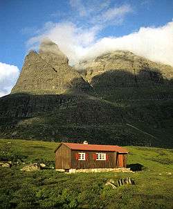
In the southern part of the municipality lies the Dovrefjell–Sunndalsfjella National Park, home to a plentiful amount of impressive muskox. In the northern part is the Trollheimen and Innerdalen landscape protection areas.
The municipality centers around the Sunndalsfjorden and the river Driva. There are also many towering mountains including: Trolla, Storskrymten, Vinnufjellet (with peaks Dronningkrona and Kongskrona), Innerdalstårnet, Såtbakkollen, Skarfjellet, and Vassnebba. The Vinnufossen waterfall lies near the river Driva.
Government
All municipalities in Norway, including Sunndal, are responsible for primary education (through 10th grade), outpatient health services, senior citizen services, unemployment and other social services, zoning, economic development, and municipal roads. The municipality is governed by a municipal council of elected representatives, which in turn elect a mayor.
Municipal council
The municipal council (Kommunestyre) of Sunndal is made up of 27 representatives that are elected to four year terms. Currently, the party breakdown is as follows:[6]
| Party Name | Name in Norwegian | Number of representatives | |
|---|---|---|---|
| Labour Party | Arbeiderpartiet | 15 | |
| Progress Party | Fremskrittspartiet | 3 | |
| Conservative Party | Høyre | 1 | |
| Christian Democratic Party | Kristelig Folkeparti | 1 | |
| Centre Party | Senterpartiet | 4 | |
| Socialist Left Party | Sosialistisk Venstreparti | 2 | |
| Liberal Party | Venstre | 1 | |
| Total number of members: | 27 | ||
References
- ↑ "Navn på steder og personer: Innbyggjarnamn" (in Norwegian). Språkrådet. Retrieved 2015-12-01.
- ↑ Statistisk sentralbyrå (2017). "Table: 06913: Population 1 January and population changes during the calendar year (M)" (in Norwegian). Retrieved 2017-10-19.
- ↑ Jukvam, Dag (1999). "Historisk oversikt over endringer i kommune- og fylkesinndelingen" (PDF) (in Norwegian). Statistisk sentralbyrå.
- ↑ Rygh, Oluf (1908). Norske gaardnavne: Romsdals amt (in Norwegian) (13 ed.). Kristiania, Norge: W. C. Fabritius & sønners bogtrikkeri. p. 388.
- ↑ "Kommunevåpen Sunndal" (in Norwegian). Sunndal Kommune. Retrieved 2008-10-19.
- ↑ "Table: 04813: Members of the local councils, by party/electoral list at the Municipal Council election (M)" (in Norwegian). Statistics Norway. 2015.
External links


- Municipal fact sheet from Statistics Norway (in Norwegian)
- Sunndalsnett (in Norwegian)
- Culture in Sunndal on the map from Kulturnett.no (in Norwegian)
- Sunndal kommune (Municipality of Sunndal) (in Norwegian)