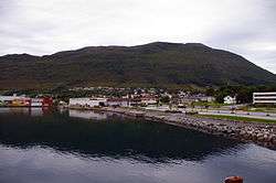
Hareid
| Hareid kommune | |||
|---|---|---|---|
| Municipality | |||
 | |||
| |||
 Hareid within Møre og Romsdal | |||
| Coordinates: 62°21′51″N 06°00′05″E / 62.36417°N 6.00139°ECoordinates: 62°21′51″N 06°00′05″E / 62.36417°N 6.00139°E | |||
| Country | Norway | ||
| County | Møre og Romsdal | ||
| District | Sunnmøre | ||
| Administrative centre | Hareid | ||
| Government | |||
| • Mayor (2011) | Anders Riise (H) | ||
| Area | |||
| • Total | 82.26 km2 (31.76 sq mi) | ||
| • Land | 76.81 km2 (29.66 sq mi) | ||
| • Water | 5.45 km2 (2.10 sq mi) | ||
| Area rank | #391 in Norway | ||
| Population (2017) | |||
| • Total | 5,185 | ||
| • Rank | #194 in Norway | ||
| • Density | 67.5/km2 (175/sq mi) | ||
| • Change (10 years) | 10.9% | ||
| Demonym(s) | Hareidstøling[1] | ||
| Time zone | UTC+01:00 (CET) | ||
| • Summer (DST) | UTC+02:00 (CEST) | ||
| ISO 3166 code | NO-1517 | ||
| Official language form | Nynorsk | ||
| Website |
www | ||
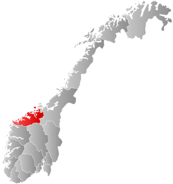
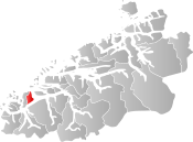
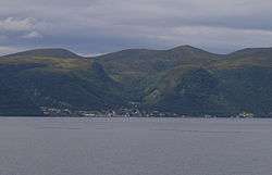
Hareid is a municipality in Møre og Romsdal county, Norway. It is part of the Sunnmøre region. The administrative centre is the village of Hareid. The other main population centers are Brandal and Hjørungavåg.
The municipality is situated off the mainland coast of Sunnmøre, on an island named Hareidlandet, which it shared with Ulstein Municipality, the commercial capital of the area. Hareid is regarded as the cultural capital with its annual Hareidsstemne and many choirs. It is also an important traffic hub in Sunnmøre and is connected by ferry to the neighboring island of Sula which in turn is connected to the city of Ålesund and the island of Valderøya. The municipality is connected to the mainland via the Eiksund Bridge and Eiksund Tunnel through Ulstein.
The 82-square-kilometre (32 sq mi) municipality is the 391st largest by area out of the 422 municipalities in Norway. Hareid is the 194th most populous municipality in Norway with a population of 5,185. The municipality's population density is 67.5 inhabitants per square kilometre (175/sq mi) and its population has increased by 10.9% over the last decade.[2]
General information
The municipality of Hareid was established on 1 January 1917 when it was separated from Ulstein Municipality to form a municipality of its own. Originally, the municipality included the eastern part of Hareidlandet island and the southwestern part of Sula island. The initial population was 2,310. On 1 July 1958, the southwestern part of the island of Sula (population: 68) was transferred from Hareid Municipality to Borgund Municipality.[3]
Name
The municipality (originally the parish) is named after the old Hareid farm (Old Norse: Haðareið), since the first church (Hareid Church) was built there. The first element is the genitive case of the name of the island Hǫð (now Hareidlandet) and the last element is eið which means "isthmus". The meaning of the name of the island is unknown.[4] It is however speculated that it might be connected to the Norse god Höðr
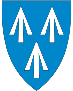
Coat-of-arms
The coat-of-arms is from modern times. They were granted on 11 January 1985. The arms show three arrowheads as a symbol for the Battle of Hjörungavágr in 986, in which Earl Håkon defeated the Danish Vikings. This battle played an important role in the struggle by Håkon to unite the whole of Norway. Since the battle took place in the municipality, the arrowheads were considered an appropriate symbol.[5]
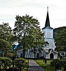
Churches
The Church of Norway has one parish (sokn) within the municipality of Hareid. It is part of the Søre Sunnmøre deanery in the Diocese of Møre.
| Parish (Sokn) | Church Name | Location of the Church | Year Built |
|---|---|---|---|
| Hareid | Hareid Church | Hareid | 1877 |
Government
All municipalities in Norway, including Hareid, are responsible for primary education (through 10th grade), outpatient health services, senior citizen services, unemployment and other social services, zoning, economic development, and municipal roads. The municipality is governed by a municipal council of elected representatives, which in turn elect a mayor.
Municipal council
The municipal council (Kommunestyre) of Hareid is made up of 21 representatives that are elected to four year terms. Currently, the party breakdown is as follows:[6]
| Party Name | Name in Norwegian | Number of representatives | |
|---|---|---|---|
| Labour Party | Arbeiderpartiet | 3 | |
| Progress Party | Framstegspartiet | 4 | |
| Conservative Party | Høgre | 5 | |
| Christian Democratic Party | Kristelig Folkeparti | 2 | |
| Liberal Party | Venstre | 2 | |
| Local Lists | Lokale lister | 5 | |
| Total number of members: | 21 | ||
Economy
Primary industries
Primary industries such as fisheries and agriculture have traditionally been important ways of life in Hareid, and continue to be so for some of the population.
Industry
In recent years Hareid has developed into a modern industrial municipality with a variety of industries, including furniture, fish farming, offshore and subsea ship systems, and other manufacturers of ship equipment. Many Hareid companies specialize in manufacturing maritime equipment and components, and are part of the maritime cluster of Sunnmøre. Such clusters are considered by the EU to be powerful engines of economic development and drivers for innovation in Europe.[7]
Industrial companies
- Ekornes (furniture)
- Hareid Group (electrical systems)
- Jets (vacuum sanitation)
- Kvalsvik Produksjon (kitchen furniture)
- Libra Plast (ship doors)
- Norway Pelagic (fish processing plant)
- Rolls Royce Marine (maritime equipment)
- Spenncon (precast concrete)
- Stromek (maritime equipment)
- Vital Base (specialized pillows and cushions)
Education
The town centre of Hareid is home to Hareid elementary school and Hareid junior high school, with two more elementary schools in more rural parts of the municipality.
- Hareid elementary school, grades 1 through 7
- Bigset elementary school, grades 1 through 7
- Hjørungavåg elementary school, grades 1 through 7
- Hareid junior high school, grades 8 through 10
After finishing junior high school in Hareid, students can complete a high school education in one of Hareid's neighbouring communities such as Ulsteinvik or Ålesund.
References
- ↑ "Navn på steder og personer: Innbyggjarnamn" (in Norwegian). Språkrådet. Retrieved 2015-12-01.
- ↑ Statistisk sentralbyrå (2017). "Table: 06913: Population 1 January and population changes during the calendar year (M)" (in Norwegian). Retrieved 2017-10-15.
- ↑ Jukvam, Dag (1999). "Historisk oversikt over endringer i kommune- og fylkesinndelingen" (PDF) (in Norwegian). Statistisk sentralbyrå.
- ↑ Rygh, Oluf (1908). Norske gaardnavne: Romsdals amt (in Norwegian) (13 ed.). Kristiania, Norge: W. C. Fabritius & sønners bogtrikkeri. p. 56.
- ↑ Norske Kommunevåpen (1990). "Nye kommunevåbener i Norden". Retrieved 19 October 2008.
- ↑ "Table: 04813: Members of the local councils, by party/electoral list at the Municipal Council election (M)" (in Norwegian). Statistics Norway. 2015.
- ↑ European Commission Maritime Affairs. "Maritime Clusters". Archived from the original on 2009-07-19. Retrieved 2010-10-28.
External links
- Official municipality website (in Norwegian)


- Municipal fact sheet from Statistics Norway (in Norwegian)