Rauma, Norway
| Rauma kommune | |||
|---|---|---|---|
| Municipality | |||
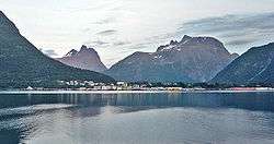 View of Åndalsnes in Rauma | |||
| |||
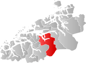 Rauma within Møre og Romsdal | |||
| Coordinates: 62°30′17″N 07°46′55″E / 62.50472°N 7.78194°ECoordinates: 62°30′17″N 07°46′55″E / 62.50472°N 7.78194°E | |||
| Country | Norway | ||
| County | Møre og Romsdal | ||
| District | Romsdal | ||
| Administrative centre | Åndalsnes | ||
| Government | |||
| • Mayor (2011) | Lars Olav Hustad (H) | ||
| Area | |||
| • Total | 1,502.15 km2 (579.98 sq mi) | ||
| • Land | 1,441.97 km2 (556.75 sq mi) | ||
| • Water | 60.18 km2 (23.24 sq mi) | ||
| Area rank | #51 in Norway | ||
| Population (2017) | |||
| • Total | 7,503 | ||
| • Rank | #143 in Norway | ||
| • Density | 5.2/km2 (13/sq mi) | ||
| • Change (10 years) | 2.4% | ||
| Demonym(s) | Raumaværing[1] | ||
| Time zone | UTC+01:00 (CET) | ||
| • Summer (DST) | UTC+02:00 (CEST) | ||
| ISO 3166 code | NO-1539 | ||
| Official language form | Neutral | ||
| Website |
www | ||

Rauma is a municipality in Møre og Romsdal county, Norway. It is part of the traditional district of Romsdal. The administrative centre is the town of Åndalsnes. Other settlements in Rauma include the villages of Vågstranda, Måndalen, Innfjorden, Veblungsnes, Verma, Isfjorden, Eidsbygda, Rødven, Åfarnes, and Mittet. Most settlement in the municipality is located along the fjords and in the Romsdalen valley.
The municipality surrounds part of the southern end of Romsdalsfjorden and the Isfjorden and it also includes the Romsdalen valley and Romsdalsalpene mountains. In the lower part of the valleys and around Romsdal Fjord and Rødvenfjorden are driven agriculture with emphasis on livestock. The clothing industry has traditionally been a dominant industry in the municipality, especially in Isfjorden. In the summer, Rauma has a fairly large amount of tourist traffic. The top tourist attractions include mountain climbing/hiking, salmon fishing, Trollstigen, and the historic Rødven Stave Church.[2]
The 1,502-square-kilometre (580 sq mi) municipality is the 51st largest by area out of the 422 municipalities in Norway. Rauma is the 143rd most populous municipality in Norway with a population of 7,503. The municipality's population density is 5.2 inhabitants per square kilometre (13/sq mi) and its population has increased by 2.4% over the last decade.[3]
General information
The municipality of Rauma was established on 1 January 1964 when the old municipalities of Eid (population: 381), Grytten (population: 3,683), Hen (population: 1,663), Voll (population: 1,163), and the southern part of Veøy (population: 1,400) were all merged to form one large municipality. The municipal borders have not changed since that time.[4]
Name
The municipality is named after the Rauma River, which flows through the Romsdalen valley.[5]
Coat-of-arms
The coat-of-arms is from modern times. They were granted on 4 November 1983. The three points on the arms represent the two and a half mountains of Vengetindane, Trolltindane and Romsdalshornet, all located in the municipality.[6]
Churches
The Church of Norway has seven parishes (sokn) within the municipality of Rauma. It is part of the Indre Romsdal deanery in the Diocese of Møre.
| Parish (Sokn) | Church Name | Location of the Church | Year Built |
|---|---|---|---|
| Eid og Holm | Eid Church | Eidsbygda | 1796 |
| Holm Church | Holm | 1907 | |
| Rødven Church | Rødven | 1907 | |
| Rødven Stave Church | Rødven | c. 1200 | |
| Grytten | Grytten Church | Veblungsnes | 1829 |
| Hen | Hen Church | Isfjorden | 1831 |
| Kors | Kors Church | Marstein in Romsdalen | 1797 |
| Voll | Voll Church | Voll | 1896 |
| Innfjorden Chapel | Innfjorden | 1976 | |
| Vågstranda | Vågstranda Church | Vågstranda | 1870 |
| Øverdalen | Øverdalen Church | Verma | 1902 |
Geography
The municipality surrounds the eastern part of Romsdal Fjord, Isfjorden, and Rødvenfjorden, and it is south of the Langfjorden. It also surrounds the Romsdalen valley and the Rauma River from the mouth to the Oppland county border.
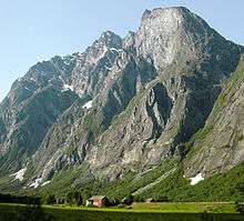
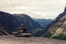
The Kyrkjetaket and Gjuratinden mountains lie in the northeastern part of the municipality. The mountains Romsdalshornet, Store Trolltind, Trollryggen, Store Venjetinden, and the Troll Wall are all in the central part of the municipality in the Romsdalsalpene mountain range. The mountains Karitinden and Puttegga are located in the southwestern part of the municipality. Part of Reinheimen National Park lies within the municipality.
Transportation
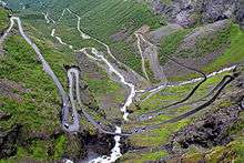
European Route E136, Norwegian County Road 63, and Norwegian County Road 64 all pass through the municipality. The Trollstigen road is part of County Road 63 in Rauma, and it is a famous tourist attraction due to the many hairpin turns on the steep road.
The Rauma railway line also runs through the municipality, over the Kylling Bridge, and terminates at Åndalsnes Station. The nearest airports are Ålesund Airport which is 135 kilometres (84 mi) by road from Åndalsnes and Molde Airport which is 55 kilometres (34 mi) by road plus a road ferry.
Government
All municipalities in Norway, including Rauma, are responsible for primary education (through 10th grade), outpatient health services, senior citizen services, unemployment and other social services, zoning, economic development, and municipal roads. The municipality is governed by a municipal council of elected representatives, which in turn elect a mayor.
Municipal council
The municipal council (Kommunestyre) of Rauma is made up of 27 representatives that are elected to four year terms. Currently, the party breakdown is as follows:[7]
| Party Name | Name in Norwegian | Number of representatives | |
|---|---|---|---|
| Labour Party | Arbeiderpartiet | 5 | |
| Progress Party | Fremskrittspartiet | 2 | |
| Conservative Party | Høyre | 8 | |
| Christian Democratic Party | Kristelig Folkeparti | 2 | |
| Centre Party | Senterpartiet | 7 | |
| Socialist Left Party | Sosialistisk Venstreparti | 2 | |
| Liberal Party | Venstre | 1 | |
| Total number of members: | 27 | ||
Attractions

Rauma is frequently visited by tourists, especially due to the major sights:
- Trollveggen in Romsdalen valley
- Trollstigen road to Geiranger
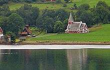
- Rødven Stave Church (built around the year 1200)
References
- ↑ "Navn på steder og personer: Innbyggjarnamn" (in Norwegian). Språkrådet. Retrieved 2015-12-01.
- ↑ Store norske leksikon. "Rauma" (in Norwegian). Retrieved 2013-06-02.
- ↑ Statistisk sentralbyrå (2017). "Table: 06913: Population 1 January and population changes during the calendar year (M)" (in Norwegian). Retrieved 2017-10-18.
- ↑ Jukvam, Dag (1999). "Historisk oversikt over endringer i kommune- og fylkesinndelingen" (PDF) (in Norwegian). Statistisk sentralbyrå.
- ↑ Rygh, Oluf (1908). Norske gaardnavne: Romsdals amt (in Norwegian) (13 ed.). Kristiania, Norge: W. C. Fabritius & sønners bogtrikkeri. p. 239.
- ↑ Norske Kommunevåpen (1990). "Nye kommunevåbener i Norden". Retrieved 19 October 2008.
- ↑ "Table: 04813: Members of the local councils, by party/electoral list at the Municipal Council election (M)" (in Norwegian). Statistics Norway. 2015.
External links


- Municipal fact sheet from Statistics Norway (in Norwegian)