Averøy
| Averøy kommune | |||
|---|---|---|---|
| Municipality | |||
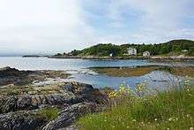
 View of Mekknoken in Averøy | |||
| |||
 Averøy within Møre og Romsdal | |||
| Coordinates: 62°59′50″N 07°33′19″E / 62.99722°N 7.55528°ECoordinates: 62°59′50″N 07°33′19″E / 62.99722°N 7.55528°E | |||
| Country | Norway | ||
| County | Møre og Romsdal | ||
| District | Nordmøre | ||
| Administrative centre | Bruhagen | ||
| Government | |||
| • Mayor (2015) | Ingrid Ovidie Rangønes (Ap) | ||
| Area | |||
| • Total | 175.68 km2 (67.83 sq mi) | ||
| • Land | 172.87 km2 (66.75 sq mi) | ||
| • Water | 2.81 km2 (1.08 sq mi) | ||
| Area rank | #347 in Norway | ||
| Population (2017) | |||
| • Total | 5,856 | ||
| • Rank | #179 in Norway | ||
| • Density | 33.9/km2 (88/sq mi) | ||
| • Change (10 years) | 9.1% | ||
| Demonym(s) | Averøying[1] | ||
| Time zone | UTC+01:00 (CET) | ||
| • Summer (DST) | UTC+02:00 (CEST) | ||
| ISO 3166 code | NO-1554 | ||
| Official language form | Neutral | ||
| Website |
www | ||
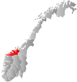
Averøy is a municipality in Møre og Romsdal county, Norway. It is part of the region of Nordmøre. The administrative centre of the municipality is the village of Bruhagen. Other villages in the municipality include Bremsnes, Kornstad, Kvernes, Kårvåg, Langøy, Sveggen, and Vebenstad.
The municipality includes the main island of Averøya and the many small islands surrounding it. The Kornstadfjorden, Kvernesfjorden, and Bremsnesfjorden surround the municipality on three sides and the open ocean on the fourth side. The Hestskjær Lighthouse and Stavnes Lighthouse are located in the northern part of the municipality.
The 176-square-kilometre (68 sq mi) municipality is the 347th largest by area out of the 422 municipalities in Norway. Averøy is the 179th most populous municipality in Norway with a population of 5,856. The municipality's population density is 33.9 inhabitants per square kilometre (88/sq mi) and its population has increased by 9.1% over the last decade.[2]
General information
The municipality of Averøy was established on 1 January 1964 when the former municipality of Kvernes and most of the municipalities of Kornstad and Bremsnes were merged into one big municipality. On 1 January 1983, the small island of Eldhusøya (and the small surrounding islands) was transferred from Eide Municipality to Averøy Municipality.[3]
Name
The municipality is named after the island Averøya (or Averøy) (Old Norse: Afrøy). The meaning of the first element is unknown (maybe afr which means "great" or "big") and the ending -øya or -øy means "island".[4]
Coat-of-arms
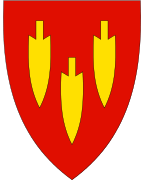
The coat-of-arms is from modern times. They were granted on 4 April 1986. The arms show three Stone Age arrowheads in gold on a red background. The arrowheads refer to actual arrowheads, made of slate, which have been found in the municipality. The arrowheads thus symbolize the long time that the area has been inhabited.[5]
Churches
The Church of Norway has three parishes (sokn) within the municipality of Averøy. It is part of the Ytre Nordmøre deanery in the Diocese of Møre.
| Parish (Sokn) | Church Name | Location of the Church | Year Built |
|---|---|---|---|
| Kvernes | Kvernes Church | Kvernes | 1893 |
| Kvernes Stave Church | Kvernes | 14th century | |
| Kornstad | Kornstad Church | Kornstad | 1871 |
| Bremsnes | Bremsnes Church | Bremsnes | 1771 |
| Langøy Chapel | Langøy | 1935 |
History
The municipality of Averøy has many historic landmarks, like the Bremsnes cave with Mesolithic findings from the Fosna culture. Langøysund, now a remote fishing community, was once a bustling port along the main coastal route, and the site of the Compromise of 1040 between King Magnus I and the farmers along the coast. Also, the Medieval Kvernes Stave Church (built around 1300-1350).
Government
All municipalities in Norway, including Averøy, are responsible for primary education (through 10th grade), outpatient health services, senior citizen services, unemployment and other social services, zoning, economic development, and municipal roads. The municipality is governed by a municipal council of elected representatives, which in turn elect a mayor.
Municipal council
The municipal council (Kommunestyre) of Averøy is made up of 27 representatives that are elected to four year terms. Currently, the party breakdown is as follows:[6]
| Party Name | Name in Norwegian | Number of representatives | |
|---|---|---|---|
| Labour Party | Arbeiderpartiet | 9 | |
| Progress Party | Fremskrittspartiet | 4 | |
| Conservative Party | Høyre | 2 | |
| Christian Democratic Party | Kristelig Folkeparti | 2 | |
| Centre Party | Senterpartiet | 3 | |
| Socialist Left Party | Sosialistisk Venstreparti | 1 | |
| Liberal Party | Venstre | 6 | |
| Total number of members: | 27 | ||
Transportation

The tourist attraction Atlanterhavsveien (Atlantic Road) connects the island and municipality of Averøy to the neighboring Eide Municipality, which is on the mainland to the west. The Storseisundet Bridge crosses the municipal boundary. In 2005, it was awarded the "Building of the Century" prize by the Norwegian Construction Industry. On the other side of the island near Sveggen, Averøy is connected to Kristiansund Municipality via the undersea tunnel. This tunnel, known as Atlanterhavstunnelen (Atlantic Tunnel), was completed in December 2009, replacing the ferry from Bremsnes on Averøya to the city of Kristiansund.
References
| Wikivoyage has a travel guide for Averøy. |
| Wikimedia Commons has media related to Averøy. |
- ↑ "Navn på steder og personer: Innbyggjarnamn" (in Norwegian). Språkrådet. Retrieved 2015-12-01.
- ↑ Statistisk sentralbyrå (2017). "Table: 06913: Population 1 January and population changes during the calendar year (M)" (in Norwegian). Retrieved 2017-10-09.
- ↑ Jukvam, Dag (1999). "Historisk oversikt over endringer i kommune- og fylkesinndelingen" (PDF) (in Norwegian). Statistisk sentralbyrå.
- ↑ Thorsnæs, Geir, ed. (2017-08-22). "Averøy". Store norske leksikon (in Norwegian). Kunnskapsforlaget. Retrieved 2017-10-09.
- ↑ Norske Kommunevåpen (1990). "Nye kommunevåbener i Norden". Retrieved 18 October 2008.
- ↑ "Table: 04813: Members of the local councils, by party/electoral list at the Municipal Council election (M)" (in Norwegian). Statistics Norway. 2015.
External links
- Municipal fact sheet from Statistics Norway (in Norwegian)