Vigra
| Vigra herad | |
|---|---|
| Former Municipality | |
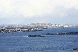 View of Vigra island | |
 Vigra herad Location in Møre og Romsdal | |
| Coordinates: 62°33′28″N 06°04′42″E / 62.55778°N 6.07833°ECoordinates: 62°33′28″N 06°04′42″E / 62.55778°N 6.07833°E | |
| Country | Norway |
| Region | Western Norway |
| County | Møre og Romsdal |
| District | Sunnmøre |
| Adm. Center | Roald |
| Time zone | UTC+01:00 (CET) |
| • Summer (DST) | UTC+02:00 (CEST) |
| ISO 3166 code | NO-1533 |
| Created from | Haram Municipality in 1890 |
| Merged into | Giske Municipality in 1964 |
Vigra is a former municipality in Møre og Romsdal county on the west coast of Norway. It is located in the present-day Giske Municipality. The former municipality was made up of the island of Vigra along with many smaller islets surrounding it. The municipality existed from 1890 until 1964 when it was merged into Giske Municipality. The administrative centre of the municipality was the village of Roald, and Vigra Church was the main church for the municipality.[1]
History
On 1 January 1890, the western islands in Haram Municipality were separated from Haram and established as Roald Municipality. The initial population was 794. In 1911, the name of the municipality was changed to Vigra. On 1 January 1964, the whole municipality of Vigra was merged into the neighboring Giske Municipality. Prior to the merger, the population of the municipality was 1,569.[2] In 1988, five nature reserves were established on the island, including the Blindheimsvik Wildlife Sanctuary.[3]
References
- ↑ Store norske leksikon. "Vigra. – kommune" (in Norwegian). Retrieved 2010-09-27.
- ↑ Jukvam, Dag (1999). "Historisk oversikt over endringer i kommune- og fylkesinndelingen" (PDF) (in Norwegian). Statistisk sentralbyrå.
- ↑ "Forskrift om vern av Blindheimsvik fuglefredingsområde, Giske kommune, Møre og Romsdal". May 27, 1988. Retrieved August 13, 2017.