Austnes
| Austnes | |
|---|---|
| Village | |
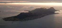 Austnes in the center, along the shore | |
 Austnes Location in Møre og Romsdal  Austnes Austnes (Norway) | |
| Coordinates: 62°38′12″N 06°16′15″E / 62.63667°N 6.27083°ECoordinates: 62°38′12″N 06°16′15″E / 62.63667°N 6.27083°E | |
| Country | Norway |
| Region | Western Norway |
| County | Møre og Romsdal |
| District | Sunnmøre |
| Municipality | Haram Municipality |
| Area[1] | |
| • Total | 0.52 km2 (0.20 sq mi) |
| Elevation[2] | 30 m (100 ft) |
| Population (2013)[1] | |
| • Total | 387 |
| • Density | 744/km2 (1,930/sq mi) |
| Time zone | UTC+01:00 (CET) |
| • Summer (DST) | UTC+02:00 (CEST) |
| Post Code | 6290 Haramsøy |
Austnes is a village in Haram Municipality in Møre og Romsdal county, Norway. It is located on the southeast side of the island of Haramsøya, about 12 kilometres (7.5 mi) southwest of the village of Longva via the Ullasund Bridge. The Ulla lighthouse is located about 7 kilometres (4.3 mi) to the north of Austnes.[3] The historic Haram Church is located in Austnes.
The 0.52-square-kilometre (130-acre) village has a population of 387, giving it a population density of 744 inhabitants per square kilometre (1,930/sq mi).[1] There is a ferry connection from Austnes to Kjerstad on nearby Lepsøya island and also to Gjerdet on the mainland.
References
- 1 2 3 Statistisk sentralbyrå (1 January 2013). "Urban settlements. Population and area, by municipality".
- ↑ "Austnes" (in Norwegian). yr.no. Retrieved 2010-10-20.
- ↑ Store norske leksikon. "Austnes" (in Norwegian). Retrieved 2010-10-20.
External links
This article is issued from
Wikipedia.
The text is licensed under Creative Commons - Attribution - Sharealike.
Additional terms may apply for the media files.