Nesset
| Nesset kommune | |||
|---|---|---|---|
| Municipality | |||
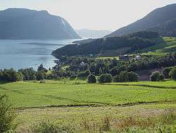
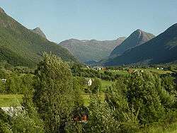 View of Vistdal in Nesset | |||
| |||
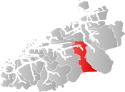 Nesset within Møre og Romsdal | |||
| Coordinates: 62°39′31″N 08°07′13″E / 62.65861°N 8.12028°ECoordinates: 62°39′31″N 08°07′13″E / 62.65861°N 8.12028°E | |||
| Country | Norway | ||
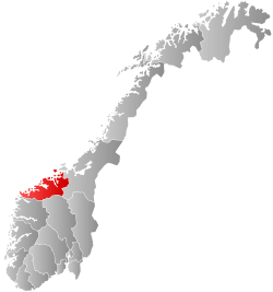
| County | Møre og Romsdal | ||
| District | Romsdal | ||
| Administrative centre | Eidsvåg | ||
| Government | |||
| • Mayor (2007) | Rolf Jonas Hurlen (H) | ||
| Area | |||
| • Total | 1,046.07 km2 (403.89 sq mi) | ||
| • Land | 985.58 km2 (380.53 sq mi) | ||
| • Water | 60.49 km2 (23.36 sq mi) | ||
| Area rank | #100 in Norway | ||
| Population (2017) | |||
| • Total | 2,963 | ||
| • Rank | #268 in Norway | ||
| • Density | 3.0/km2 (8/sq mi) | ||
| • Change (10 years) | -4.0% | ||
| Demonym(s) | Nessetgjelding[1] | ||
| Time zone | UTC+01:00 (CET) | ||
| • Summer (DST) | UTC+02:00 (CEST) | ||
| ISO 3166 code | NO-1543 | ||
| Official language form | Nynorsk | ||
| Website |
www | ||
Nesset is a municipality in Møre og Romsdal county, Norway on the Romsdal Peninsula. The administrative centre is the village of Eidsvåg. Other population centers include Rausand, Boggestranda, Myklebostad, Eresfjord, and Eikesdalen.
Mardalsfossen, one of Norway's tallest waterfalls, a popular tourist attraction during the tourist season, is located in Nesset, along the shores of the lake Eikesdalsvatnet.
The 1,046-square-kilometre (404 sq mi) municipality is the 100th largest by area out of the 422 municipalities in Norway. Nesset is the 268th most populous municipality in Norway with a population of 2,963. The municipality's population density is 3 inhabitants per square kilometre (7.8/sq mi) and its population has decreased by 4% over the last decade.[2]
General information


The parish of Nesset was established as a municipality on 1 January 1838 (see formannskapsdistrikt). On 1 January 1890, all of Nesset south of the Langfjorden was separated to form the new municipality of Eresfjord og Vistdal. This split left Nesset with 1,706 residents. On 1 January 1877, the Sotnakken farm on the Romsdal peninsula (population: 19) was transferred from Nesset to neighboring Bolsøy municipality. Also on that date, the Tiltereidet and Meisalstranda areas (population: 212) of Tingvoll Municipality, along the west coast of the Tingvollfjorden, were transferred to Nesset Municipality. On 1 January 1890, the Bersås, Nævergjeld, Rausandhaugen, and Rausand area (population: 101) was transferred from Tingvoll Municipality (along the Tingvollfjorden) to Nesset Municipality. Then on 1 January 1964, Eresfjord og Vistdal Municipality was merged back into Nesset Municipality. Prior to the merger, Nesset had 2,360 residents.[3]
On 1 January 2020, the municipality of Nesset is scheduled to be merged with the neighboring municipalities of Molde and Midsund to form a much larger Molde Municipality.[4]
Name
The municipality (originally the parish) is named after the old Nesset farm and vicarage (Old Norse: Nøytisætr, spelled "Nødesetter" in 1520) since this is where the old Nesset Church was located. The first element is probably nes which means "headlands" (since the farm is lying on a prominent headland between the Langfjorden and the Tingvollfjorden) and the last element is setr or sætr which means "farm". Before 1889, the name was written Næsset.[5]
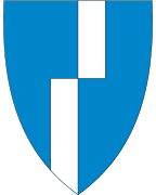
Coat-of-arms
The coat-of-arms is from modern times. They were granted on 10 March 1986. The broken gray line symbolizes the two stage drop on one of Europe's highest waterfalls, the Mardalsfossen, which is located in the municipality. The designer was Olav Sandø, from Eidsvåg.[6]
Churches
The Church of Norway has four parishes (sokn) within the municipality of Nesset. It is part of the Indre Romsdal deanery in the Diocese of Møre.
| Parish (sokn) | Church name | Location | Year built |
|---|---|---|---|
| Eikesdal | Eikesdal Church | Eikesdalen | 1866 |
| Eresfjord | Sira Church | Eresfjord | 1869 |
| Nesset | Nesset Church | Eidsvåg | 1878 |
| Vistdal | Vistdal Church | Myklebostad | 1869 |
Government
All municipalities in Norway, including Nesset, are responsible for primary education (through 10th grade), outpatient health services, senior citizen services, unemployment and other social services, zoning, economic development, and municipal roads. The municipality is governed by a municipal council of elected representatives, which in turn elect a mayor.
Municipal council
The municipal council (Kommunestyre) of Nesset is made up of 21 representatives that are elected to four year terms. Currently, the party breakdown is as follows:[7]
| Party Name | Name in Norwegian | Number of representatives | |
|---|---|---|---|
| Labour Party | Arbeiderpartiet | 7 | |
| Progress Party | Framstegspartiet | 1 | |
| Conservative Party | Høgre | 6 | |
| Christian Democratic Party | Kristelig Folkeparti | 2 | |
| Centre Party | Senterpartiet | 4 | |
| Local Lists | Lokale lister | 1 | |
| Total number of members: | 21 | ||
Geography
The municipality is made up mostly of the Eikesdalen valley which surrounds the lake Eikesdalsvatnet. The lake is fed from the lake Aursjøen on the border of Oppland county. The water then flows through the Aura River into the lake Eikesdalsvatnet. That water then flows into the Eira River and then on to the Eresfjorden, a branch of the Langfjorden which itself is a branch off the great Romsdal Fjord. The mountains Skjorta, Fløtatinden, and Gjuratinden surround the main valley.
Birdlife
From the shores of the fjord, to the towering mountains at 1,800 metres (5,900 ft) above sea level, the rural community of Nesset offers the visiting birder a range of habitats, and several interesting areas. One area worth checking is Eidsvågleirene. Though the selection of species will not be high, several of the commoner species can be found. The grey heron and mallard are characteristic species in the area.
References
- ↑ "Navn på steder og personer: Innbyggjarnamn" (in Norwegian). Språkrådet. Retrieved 2015-12-01.
- ↑ Statistisk sentralbyrå (2017). "Table: 06913: Population 1 January and population changes during the calendar year (M)" (in Norwegian). Retrieved 2017-10-18.
- ↑ Jukvam, Dag (1999). "Historisk oversikt over endringer i kommune- og fylkesinndelingen" (PDF) (in Norwegian). Statistisk sentralbyrå.
- ↑ "Nye Molde" (in Norwegian). Retrieved 2017-10-18.
- ↑ Rygh, Oluf (1908). Norske gaardnavne: Romsdals amt (in Norwegian) (13 ed.). Kristiania, Norge: W. C. Fabritius & sønners bogtrikkeri. p. 275.
- ↑ "Kommunevåpen - Nesset kommune". Nesset Kommune. Archived from the original on 2011-07-19. Retrieved 2008-10-19.
- ↑ "Table: 04813: Members of the local councils, by party/electoral list at the Municipal Council election (M)" (in Norwegian). Statistics Norway. 2015.
External links


- Municipal fact sheet from Statistics Norway (in Norwegian)