Hampstead (Tunstall, Virginia)
|
Hampstead | |
 | |
  | |
| Location | 1 mile (1.6 km) northwest of the junction of Rtes. 606 and 607, near Tunstall, Virginia |
|---|---|
| Coordinates | 37°35′56″N 77°07′20″W / 37.59889°N 77.12222°WCoordinates: 37°35′56″N 77°07′20″W / 37.59889°N 77.12222°W |
| Area | 1,000 acres (400 ha) |
| Built | c. 1825 |
| Architectural style | Federal |
| NRHP reference # | 70000812[1] |
| VLR # | 063-0013 |
| Significant dates | |
| Added to NRHP | December 18, 1970 |
| Designated VLR | October 6, 1970[2] |
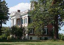
Hampstead is a historic plantation house located near Tunstall, New Kent County, Virginia. It was built about 1825, as a two-story, rectangular Federal style brick dwelling with a hipped roof. The front facade features alternating window bays and pilasters and a central two-story pedimented projecting portico. Also located on the property are the contributing ruins of a granary, an 18th-century cottage and an icehouse[3]
It was listed on the National Register of Historic Places in 1970.[1]
References
- 1 2 National Park Service (2010-07-09). "National Register Information System". National Register of Historic Places. National Park Service.
- ↑ "Virginia Landmarks Register". Virginia Department of Historic Resources. Retrieved 5 June 2013.
- ↑ Virginia Historic Landmarks Commission Staff (June 1970). "National Register of Historic Places Inventory/Nomination: Hampstead" (PDF). Virginia Department of Historic Resources. and Accompanying photo


This article is issued from
Wikipedia.
The text is licensed under Creative Commons - Attribution - Sharealike.
Additional terms may apply for the media files.