| [3] |
Name on the Register[4] |
Image |
Date listed[5] |
Location |
Description |
|---|
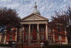
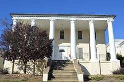
| 1 |
Augusta County Courthouse |
|
October 26, 1982
(#82001826) |
1 E. Johnson St.
38°08′56″N 79°04′20″W / 38.148889°N 79.072222°W / 38.148889; -79.072222 (Augusta County Courthouse) |
|
| 2 |
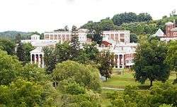
Mary Baldwin College, Main Building |
|
July 26, 1973
(#73002227) |
Mary Baldwin University campus
38°09′04″N 79°04′17″W / 38.151111°N 79.071389°W / 38.151111; -79.071389 (Mary Baldwin College, Main Building) |
|
| 3 |
Beverley Historic District |
|
July 14, 1982
(#82004598) |
U.S. Route 250 and State Route 254
38°08′57″N 79°04′22″W / 38.149167°N 79.072778°W / 38.149167; -79.072778 (Beverley Historic District) |
|
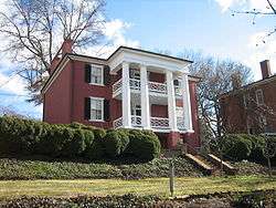
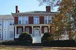
| 4 |
Breezy Hill |
|
July 8, 1982
(#82004599) |
1220 N. Augusta St.
38°09′37″N 79°04′10″W / 38.160278°N 79.069444°W / 38.160278; -79.069444 (Breezy Hill) |
|
| 5 |
Catlett House |
|
July 15, 1982
(#82004600) |
303 Berkeley Pl.
38°09′03″N 79°04′06″W / 38.150833°N 79.068333°W / 38.150833; -79.068333 (Catlett House) |
|
| 6 |
Cobble Hill Farm |
|
February 25, 2004
(#04000105) |
101 Woodlee Rd.
38°10′20″N 79°03′53″W / 38.172222°N 79.064722°W / 38.172222; -79.064722 (Cobble Hill Farm) |
|
| 7 |
Gospel Hill Historic District |
|
February 14, 1985
(#85000299) |
Roughly bounded by E. Beverly, N. Market, E. Frederick, and Kalorama Sts.
38°09′06″N 79°04′01″W / 38.151667°N 79.066944°W / 38.151667; -79.066944 (Gospel Hill Historic District) |
|
| 8 |
Hilltop |
|
June 19, 1979
(#79003298) |
Mary Baldwin University campus
38°09′07″N 79°04′17″W / 38.151944°N 79.071389°W / 38.151944; -79.071389 (Hilltop) |
|
| 9 |
Arista Hoge House |
|
July 15, 1982
(#82004601) |
215 Kalorama St.
38°08′55″N 79°04′11″W / 38.148611°N 79.069722°W / 38.148611; -79.069722 (Arista Hoge House) |
|
| 10 |
Kable House |
|
June 19, 1979
(#79003299) |
310 Prospect St.
38°09′15″N 79°04′09″W / 38.154167°N 79.069167°W / 38.154167; -79.069167 (Kable House) |
|
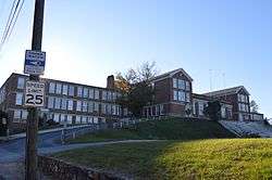
| 11 |
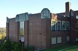
Robert E. Lee High School |
|
March 10, 2009
(#09000122) |
274 Churchville Ave.
38°09′25″N 79°04′40″W / 38.156944°N 79.077778°W / 38.156944; -79.077778 (Robert E. Lee High School) |
|
| 12 |
J.C.M. Merrillat House |
|
September 16, 1982
(#82004602) |
521 E. Beverley St.
38°09′09″N 79°03′55″W / 38.152500°N 79.065278°W / 38.152500; -79.065278 (J.C.M. Merrillat House) |
|
| 13 |
Thomas J. Michie House |
|
September 9, 1982
(#82004603) |
324 E. Beverley St.
38°08′59″N 79°04′03″W / 38.149722°N 79.067500°W / 38.149722; -79.067500 (Thomas J. Michie House) |
|
| 14 |
C.W. Miller House |
|
June 19, 1979
(#79003300) |
210 N. New St.
38°09′07″N 79°04′20″W / 38.151944°N 79.072222°W / 38.151944; -79.072222 (C.W. Miller House) |
|
| 15 |
Montgomery Hall Park |
|
February 15, 2018
(#100002139) |
1000 Montgomery Ave.
38°08′37″N 79°05′31″W / 38.143586°N 79.091964°W / 38.143586; -79.091964 (Montgomery Hall Park) |
|
| 16 |
National Valley Bank |
|
June 19, 1979
(#79003301) |
12-14 W. Beverly St.
38°08′58″N 79°04′23″W / 38.149306°N 79.073056°W / 38.149306; -79.073056 (National Valley Bank) |
|
| 17 |
Newtown Historic District |
|
September 8, 1983
(#83003318) |
Roughly bounded by Lewis St. and S. Jefferson Sts., the former Chesapeake and Ohio railroad line, and Allegheny and Churchville Aves., including Thornrose Cemetery
38°09′00″N 79°04′40″W / 38.150000°N 79.077778°W / 38.150000; -79.077778 (Newtown Historic District) |
|
| 18 |
Oakdene |
|
November 24, 1982
(#82001827) |
605 E. Beverley St.
38°09′08″N 79°03′52″W / 38.152222°N 79.064583°W / 38.152222; -79.064583 (Oakdene) |
|
| 19 |
The Oaks |
|
June 19, 1979
(#79003302) |
437 E. Beverly St.
38°09′06″N 79°03′58″W / 38.151667°N 79.066111°W / 38.151667; -79.066111 (The Oaks) |
|
| 20 |
Old Main |
|
August 13, 1974
(#74002246) |
235 W. Frederick St.
38°09′02″N 79°04′36″W / 38.150556°N 79.076667°W / 38.150556; -79.076667 (Old Main) |
|
| 21 |
Rose Terrace |
|
June 19, 1979
(#79003303) |
150 N. Market St.
38°09′08″N 79°04′16″W / 38.152222°N 79.071111°W / 38.152222; -79.071111 (Rose Terrace) |
|
| 22 |
Sears House |
|
February 23, 1972
(#72001530) |
Sears Hill Rd. in Woodrow Wilson City Park
38°08′45″N 79°04′20″W / 38.145833°N 79.072222°W / 38.145833; -79.072222 (Sears House) |
|
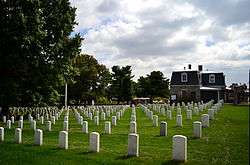
| 23 |
Staunton National Cemetery |
|
February 26, 1996
(#96000034) |
901 Richmond Ave.
38°08′25″N 79°02′59″W / 38.140278°N 79.049722°W / 38.140278; -79.049722 (Staunton National Cemetery) |
|
| 24 |
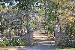
Steephill |
|
February 23, 1984
(#84003599) |
200 Park Boulevard
38°09′22″N 79°05′16″W / 38.156111°N 79.087778°W / 38.156111; -79.087778 (Steephill) |
|
| 25 |
Stuart Addition Historic District |
|
May 3, 1984
(#84003604) |
Roughly bounded by Augusta, Sunnyside, Market, and New Sts.
38°09′11″N 79°04′19″W / 38.153056°N 79.071944°W / 38.153056; -79.071944 (Stuart Addition Historic District) |
|
| 26 |
Stuart House |
|
May 5, 1972
(#72001531) |
120 Church St.
38°08′51″N 79°04′33″W / 38.147500°N 79.075833°W / 38.147500; -79.075833 (Stuart House) |
|
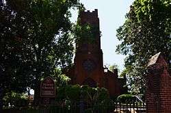
| 27 |
Trinity Episcopal Church |
|
May 5, 1972
(#72001532) |
Beverley and Lewis Sts.
38°08′56″N 79°04′31″W / 38.148889°N 79.075278°W / 38.148889; -79.075278 (Trinity Episcopal Church) |
|
| 28 |
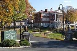
Virginia School for the Deaf and the Blind |
|
November 12, 1969
(#69000361) |
E. Beverly St. and Pleasant Terrace
38°09′02″N 79°03′50″W / 38.150556°N 79.063889°W / 38.150556; -79.063889 (Virginia School for the Deaf and the Blind) |
|
| 29 |
Booker T. Washington High School |
|
September 3, 2014
(#14000550) |
1114 W. Johnson St.
38°08′51″N 79°04′54″W / 38.147500°N 79.081667°W / 38.147500; -79.081667 (Booker T. Washington High School) |
|
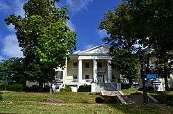
| 30 |
Waverly Hill |
|
July 8, 1982
(#82004604) |
3001 N. Augusta St.
38°10′10″N 79°02′40″W / 38.169444°N 79.044444°W / 38.169444; -79.044444 (Waverly Hill) |
|
| 31 |
Western State Hospital Complex |
|
November 25, 1969
(#69000362) |
Junction of U.S. Routes 11 and 250; also 301 Greenville Ave. and the southeastern corner of the junction of U.S. Routes 11 and 250
38°08′42″N 79°04′02″W / 38.145000°N 79.067222°W / 38.145000; -79.067222 (Western State Hospital Complex) |
Boundaries repeatedly increased at 301 Greenville Ave., on February 21, 2007, July 24, 2007, and March 23, 2010 |
| 32 |
Wharf Area Historic District |
|
November 9, 1972
(#72001533) |
Middlebrook Ave. between S. New and S. Lewis Sts., including S. Augusta St. to Johnson St.; also east to Lewis Creek
38°08′51″N 79°04′23″W / 38.147500°N 79.073056°W / 38.147500; -79.073056 (Wharf Area Historic District) |
Lewis Creek represents a boundary increase of July 19, 1982 |
| 33 |
Woodrow Wilson Birthplace |
|
October 15, 1966
(#66000926) |
N. Coalter St. between Beverly and Frederick Sts.
38°09′02″N 79°04′08″W / 38.150694°N 79.068889°W / 38.150694; -79.068889 (Woodrow Wilson Birthplace) |
|
.jpg)
.jpg)
_Staunton_VA.JPG)
.jpg)
.jpg)