List of Farm to Market Roads in Texas (600–699)
|
Texas Farm to Market Road and Ranch to Market Road markers | |
| Highway names | |
|---|---|
| Interstates | Interstate Highway X (IH-X, I-X) |
| US Highways | U.S. Highway X (US X) |
| State | State Highway X (SH X) |
| Loops: | Loop X |
| Spurs: | Spur X |
| Farm or Ranch to Market Roads: |
Farm to Market Road X (FM X) Ranch-to-Market Road X (RM X) |
| Park Roads: | Park Road X (PR X) |
| System links | |
Farm to Market Roads in Texas are owned and maintained by the Texas Department of Transportation (TxDOT).
FM 600
| |
|---|---|
| Location | Haskell, Jones and Taylor counties |
| Length | 54.543 mi[1][nb 1] (87.778 km) |
| Existed | July 25, 1945[1]–present |
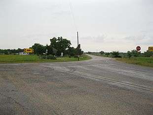
Farm to Market Road 600 (or FM 600) is located in Haskell, Jones and Taylor counties.
FM 600 begins at I-20 in Abilene and runs in a northern direction along West Lake Road before turning northeast at FM 3308 and turning back north at FM 3034. In northern Abilene, the highway runs near the western shore of Fort Phantom Hill Lake, leaving the city limits north of the FM 1082 intersection. FM 600 runs through rural areas of Jones County, intersecting US 180 east of Anson and has a short overlap with SH 6 through the town of Avoca. After the overlap with SH 6, the highway runs in an eastern direction before turning back north at County Road 223. FM 600 crosses over Lake Stamford before sharing an overlap with FM 618 near Paint Creek. The highway runs through rural areas of Haskell County before ending at an intersection with US 380 on the eastern edge of Haskell.
FM 600 was designated on July 25, 1945, running from US 380 (now SH 6) to a point 8 miles to the northeast. On December 16, 1948, the highway was extended further north to FM 142. On September 27, 1960, FM 600 was extended north to FM 618. On October 22, 1962, FM 600 was rerouted over a section of FM 142 south and west to US 380 (now SH 6), while the old route east and south to Lueders was transferred to FM 142. FM 600 absorbed FM 1834 north of FM 618 and FM 1193 south of US 380, extending the highway to I-20.[2][3][4] On June 27, 1995, the section of FM 600 between I-20 and FM 3034 was internally re-designated as Urban Road 600 by TxDOT.[5]
- Junction list
| County | Location | mi[6] | km | Destinations | Notes |
|---|---|---|---|---|---|
| Taylor | Abilene | 0.0 | 0.0 | I-20 exit 286C | |
| 1.3 | 2.1 | ||||
| Jones | 2.6 | 4.2 | |||
| 8.5 | 13.7 | South end of FM 1082 overlap | |||
| 9.2 | 14.8 | North end of FM 1082 overlap | |||
| | 20.9 | 33.6 | |||
| | 23.9 | 38.5 | |||
| Avoca | 28.3 | 45.5 | South end of SH 6 overlap | ||
| 28.7 | 46.2 | North end of SH 6 overlap | |||
| | 36.5 | 58.7 | |||
| Haskell | | 43.4 | 69.8 | ||
| | 46.5 | 74.8 | South end of FM 618 overlap | ||
| | 48.4 | 77.9 | North end of FM 618 overlap | ||
| Haskell | 57.3 | 92.2 | |||
1.000 mi = 1.609 km; 1.000 km = 0.621 mi
| |||||
FM 601
| |
|---|---|
| Location | Shackelford County |
| Length | 12.673 mi[7] (20.395 km) |
| Existed | July 25, 1945[7]–present |
FM 602
| |
|---|---|
| Location | Floyd County |
| Length | 13.103 mi[8] (21.087 km) |
| Existed | May 23, 1951[8]–present |
Farm to Market Road 602 is located in Floyd County. It runs from FM 786 at Rushing Chapel to FM 1958. There is a concurrency with US 70.
FM 602 was designated on May 23, 1951 from FM 786 at Rushing Chapel south to US 70. On October 26, 1983 the section from US 70 to FM 1958 was added, creating a concurrency with US 70.
FM 602 (1945)
| |
|---|---|
| Location | Callahan County |
| Existed | June 6, 1945[8]–September 26, 1945 |
The first FM 602 was designated on June 6, 1945 from Cross Plains south to the Brown County line. On August 23, 1945, SH 279 extended north over FM 602, but FM 602 was not cancelled yet. On September 26, 1945, FM 602 was cancelled as it was already a portion of SH 279.
FM 603
| |
|---|---|
| Location | Callahan County |
| Length | 11.231 mi[9] (18.075 km) |
| Existed | June 6, 1945[9]–present |
Farm to Market Road 603 (FM 603) is located in rural Callahan County.[9]
FM 603 begins at SH 36 west of the community of Denton.[10] It proceeds north, passing through the community of Eula. It crosses FM 18 before reaching its northern terminus at I-20 west of Clyde.[11]
FM 603 was designated on June 6, 1945 from Eula to what was then US 80, a distance of 4.8 miles (7.7 km). On September 19, 1951, US 80 was relocated a mile to the north, and the old route was replaced by FM 18.[12] On October 31, 1958, FM 603 was extended south to SH 36, increasing its length to 10.6 miles (17.1 km). On September 20, 1961, it was extended an additional half mile to the north, to the new routing of US 80, which later became I-20.[9]
FM 604
| |
|---|---|
| Location | Taylor, Callahan, and Shackelford counties |
| Length | 51.086 mi[13] (82.215 km) |
| Existed | June 6, 1945[13]–present |
FM 605
| |
|---|---|
| Location | Jones County |
| Length | 14.132 mi[14] (22.743 km) |
| Existed | June 6, 1945[14]–present |
FM 606
| |
|---|---|
| Location | Willacy County |
| Length | 0.795 mi[15] (1.279 km) |
| Existed | October 26, 1954[15]–present |
Farm to Market Road 606 is located in Willacy County, in the Rio Grande Valley. The highway is located entirely within the community of Port Mansfield, passing through mainly residential areas.
FM 606 begins at its southern terminus, Texas State Highway 186, as a two-lane, paved road. The highway is located less than 200 yards from the Gulf of Mexico.[16] The road proceeds north-northwest, passing numerous small houses and empty housing lots and intersecting several small local roads. The highway bends slightly, proceeding in a northward direction and passing several more houses before intersecting County Road 4150. The route continues northward, passing several more small houses and lots before passing a small park and the Fred Stone County Fishing Pier.[17] The highway proceeds a short distance northward before reaching its northern terminus at a dead end point.[18][19]
FM 606 was designated on October 26, 1954 on the current route, from FM 497 (now SH 186) to a dead end point.
FM 606 (1945)
| |
|---|---|
| Location | Jones County |
| Existed | July 26, 1945[15]–October 22, 1954 |
The first FM 606 was designated on July 26, 1945 from US 180 at Boys Chapel 4 miles north to Hamlin Lake. On December 16, 1948, the route was extended north 4.1 miles to US 83. FM 606 was cancelled on October 22, 1954 and combined with FM 126.
FM 607
| |
|---|---|
| Location | Henderson County |
| Length | 14.160 mi[20] (22.788 km) |
| Existed | November 20, 1951[20][21]–present |
Farm to Market Road 607 is located in Henderson County. It runs from SH 31 at Brownsboro to Loop 60 at La Rue.
FM 607 was designated on November 20, 1951 on the current route.
FM 607 (1945)
| |
|---|---|
| Location | Nolan County |
| Existed | July 28, 1945[20]–November 20, 1951 |
The first FM 607 was designated on July 28, 1945 from FM 53 east via Nolan to Dora. On August 26, 1948 the road was extended to the Taylor County line. FM 607 was cancelled on November 20, 1951 and combined with FM 126.
FM 608
| |
|---|---|
| Location | Nolan, Fisher counties |
| Length | 39.425 mi[22] (63.448 km) |
| Existed | July 26, 1945[22]–present |
FM 608 was designated on July 26, 1945, from US 80 (now Busines I-20) in Roscoe south 8 miles to Highland School. On February 27, 1948, FM 608 extended to Maryneal. On September 29, 1954, FM 608 extended northeast to SH 70. On October 31, 1957, FM 608 extended to the Nolan-Fisher County Line. On September 27, 1960, FM 608 extended north to FM 611, completing its current route.
FM 609
| |
|---|---|
| Location | Fayette County |
| Length | 20.095 mi[23] (32.340 km) |
| Existed | May 23, 1951[23]–present |
Farm to Market Road 609 is located in Fayette County. It runs from US 90 in Flatonia northeast to Business SH 71-E west of La Grange.
FM 609 was designated om May 23, 1951 from US 90 in Flatonia northeast 3.8 miles to a road intersection. On November 20, 1951, the road was extended 8.7 miles northeast. On December 17, 1952, the road was extended northeast to SH 71 (now Business SH 71-E), replacing FM 1294. On September 5, 1973 the section from SH 71 northwest 2.5 miles was added, creating a concurrency with SH 71. This concurrency was removed in 1977, when the section was cancelled.
FM 609 (1945)
| |
|---|---|
| Location | Fisher County |
| Existed | July 23, 1945[23]–December 16, 1948 |
The first FM 609 was designated on July 23, 1945 from Longworth west to SH 70. FM 609 was cancelled on December 16, 1948 and combined with FM 57.
FM 610
| |
|---|---|
| Location | Fisher and Stonewall counties |
| Length | 20.611 mi[24] (33.170 km) |
| Existed | July 23, 1945[24]–present |
FM 611 was designated on July 23, 1945, from SH 70 to the Stonewall-Fisher County Line. Seven days later, FM 610 extended to Aspermont.
FM 611
{{infobox road small |state=TX |type=FM |route=611 |length_mi=26.098 |length_ref=[25] |formed=July 23, 1945[25] |location=Fisher County }]
FM 611 was designated on July 23, 1945, from US 180 northward 4 miles to Hobbs. On May 23, 1951, FM 611 extended east to SH 70, replacing FM 646. On October 31, 1957, FM 611 extended south 5 miles. On October 31, 1958, FM 611 extended to its end at FM 419.
FM 612
| |
|---|---|
| Location | Borden and Scurry |
| Length | 21.906 mi[26] (35.254 km) |
| Existed | July 31, 1945[26]–present |
FM 613
| |
|---|---|
| Location | Taylor County |
| Length | 10.118 mi[27] (16.283 km) |
| Existed | July 30, 1945[27]–present |
FM 614
| |
|---|---|
| Location | Taylor County |
| Length | 6.534 mi[28] (10.515 km) |
| Existed | July 30, 1945[28]–present |
FM 615
| |
|---|---|
| Location | Fayette County |
| Length | 2.623 mi[29] (4.221 km) |
| Existed | May 23, 1951[29]–present |
FM 615 was designated on May 23, 1951, from US 77, 2.5 miles north of Schulenburg, eastward 2.8 miles.
FM 615 (1945)
| |
|---|---|
| Location | Taylor County |
| Existed | July 30, 1945[29]–December 16, 1948 |
The first FM 615 was designated on July 30, 1945 from Merkel southwest to Blair. FM 615 was cancelled in 1948 and combined with FM 126.
FM 616
| |
|---|---|
| Location | Victoria, Jackson and Matagorda counties |
| Length | 46.188 mi[30] (74.332 km) |
| Existed | July 25, 1945[30]–present |
Farm to Market Road 616 is located in Victoria, Jackson, and Matagorda counties. It runs from FM 404 at Bloomington to SH 35 at Blessing.
FM 616 was designated on July 25, 1945 from SH 172 at La Ward east 5 miles. On August 4, 1945, FM 616 was changed to that it instead went from SH 172 west 5 miles to Lolita. On February 25, 1949, the road was extended north 3.2 miles to a road intersection. On July 14 of that year, a 6-mile section from the end of FM 616 to SH 111 was added. on March 27, 1951, the section from SH 111 to Lolita was renumbered FM 1593, while the section from FM 234 at Vanderbilt to Lolita was added. On September 29, 1954, the road was extended west to La Salle, replacing a section of FM 234, and east to SH 35 at Blessing, replacing FM 1727 (part is former Spur 93 and previously SH 177). On October 31, 1958, the road was extended southwest to FM 404 (now SH 185) at Bloomington, replacing FM 1302.
FM 617
| |
|---|---|
| Location | Haskell County |
| Length | 28.713 mi[31] (46.209 km) |
| Existed | July 27, 1945[31]–present |
FM 618
| |
|---|---|
| Location | Haskell County |
| Length | 16.544 mi[32] (26.625 km) |
| Existed | July 27, 1945[32]–present |
FM 619
| |
|---|---|
| Location | Williamson and Lee counties |
| Length | 23.011 mi[33] (37.033 km) |
| Existed | June 11, 1945[33]–present |
Farm to Market Road 619 (FM 619) is located in Lee and Williamson counties.[33]
FM 619 begins in Lee County at FM 696, just north of the Bastrop County line.[34] It travels northward and soon enters Williamson County. The route is primarily rural and does not go through any major cities or communities, other than passing just east of Taylor, where it has a brief concurrency with FM 112 and crosses US 79.[35] The route's northern terminus is at FM 1331, south of Granger Lake.[33]
The highway has one spur route, FM Spur 619, which runs from just north of the Williamson–Lee county line eastward and southward to the county line. It is a former alignment of the main route through the community of Beaukiss.[33]
FM 619 was designated in Williamson County on June 11, 1945, beginning at FM 112 and ending in the community of Structure. The southern extension to the Lee County line, along what is the present-day route and its spur route south of the junction, occurred on December 17, 1952. On September 29, 1954, a southward extension into Lee County was designated, and the two routes were joined via a new alignment, creating the spur route. The northward extension to FM 1331 took effect on June 28, 1963.[33]
FM 620
| |
|---|---|
| Location | Travis and Williamson counties |
| Existed | July 9, 1945–October 1, 1956 |
RM 620
| |
|---|---|
| Location | Travis and Williamson counties |
| Length | 23.239 mi[36] (37.400 km) |
| Existed | October 1, 1956[36]–present |
Ranch to Market Road 620 is located in Travis and Williamson counties. It runs from SH 71 in Bee Cave to I-35 in Round Rock. RM 620 runs concurrent with the service roads of the SH 45 toll road.
RM 620 was designated on July 9, 1945 as FM 620, from US 81 (Later Loop 384 and after that, Business I-35-L) in Round Rock to SH 29 (now US 183). On April 17, 1946, the road was extended to the Travis County line. On August 26, 1948, it was extended 4.1 miles to Hickmuntown (also known as Four Points). On December 17, 1952, the road was extended 13.5 miles southwest to RM 93 (now SH 71). FM 620 was changed to RM 620 on October 1, 1956. In 1995, the entire route was transferred to UR 620. On February 28, 2013, the section from I-35 east to Business I-35-L (Business I-35-L was removed at the same time, and this section is now Mays Street) was removed from the state highway system and turned over to the city of Round Rock.
FM 621
| |
|---|---|
| Location | Hays and Guadalupe counties |
| Length | 12.848 mi[37] (20.677 km) |
| Existed | July 21, 1945[37]–present |
FM 622
| |
|---|---|
| Location | Goliad and Victoria counties |
| Length | 17.886 mi[38] (28.785 km) |
| Existed | July 19, 1945[38]–present |
FM 623
| |
|---|---|
| Location | Live Oak and Bee counties |
| Length | 21.965 mi[39] (35.349 km) |
| Existed | July 27, 1945[39]–present |
FM 624
| |
|---|---|
| Location | South Texas |
| Length | 113.802 mi[40] (183.147 km) |
| Existed | July 9, 1945[40]–present |
FM 625
| |
|---|---|
| Location | Jim Wells County |
| Length | 11.670 mi[41] (18.781 km) |
| Existed | July 9, 1945[41]–present |
FM 626
| |
|---|---|
| Location | Karnes County |
| Length | 11.444 mi[42] (18.417 km) |
| Existed | July 9, 1945[42]–present |
FM 627
| |
|---|---|
| Location | Karnes and DeWitt counties |
| Length | 17.009 mi[43] (27.373 km) |
| Existed | July 9, 1945[43]–present |
FM 628
| |
|---|---|
| Location | Kleberg County |
| Existed | July 9, 1945[44]–October 1, 1956 |
RM 628
| |
|---|---|
| Location | Kleberg County |
| Length | 11.666 mi[45] (18.775 km) |
| Existed | October 1, 1956[45]–present |
FM 629
| |
|---|---|
| Location | Refugio County |
| Length | 3.500 mi[46] (5.633 km) |
| Existed | July 5, 1945[46]–present |
FM 630
| |
|---|---|
| Location | San Patricio County |
| Length | 10.463 mi[47] (16.839 km) |
| Existed | July 9, 1945[47]–present |
FM 631
| |
|---|---|
| Location | San Patricio County |
| Length | 20.038 mi[48] (32.248 km) |
| Existed | July 9, 1945[48]–present |
FM 632
| |
|---|---|
| Location | Karnes |
| Length | 0.872 mi[49] (1.403 km) |
| Existed | October 29, 1993[49]–present |
FM 632 (1945-1969)
| |
|---|---|
| Location | San Patricio County |
| Existed | July 9, 1945[49]–March 15, 1969 |
The first use of the FM 632 designation was in San Patricio County. FM 632 was designated on July 9, 1945 from Gregory southeast to Ingleside. On June 1, 1948 the road was extended to Aransas Pass. FM 632 was cancelled on January 13, 1969 and transferred to SH 361.
RM 632
| |
|---|---|
| Location | Mason County |
| Existed | May 7, 1974[49]–March 5, 1976 |
RM 632 was cancelled on March 5, 1976 and removed from the highway system.
FM 632 (1973-1976)
| |
|---|---|
| Location | Mason County |
| Existed | September 5, 1973[49]–May 7, 1974 |
The second use of the FM 632 designation was in Mason County. FM 632 was designated on September 5, 1973 from US 87, 0.5 mile south of US 377 north of Mason, east and south to SH 29. On May 7, 1974 the road was extended north and west to RM 1871, a break in the route was added at RM 386, and FM 632 was changed to RM 632.
FM 632 (1979-1989)
| |
|---|---|
| Location | Live Oak County |
| Existed | September 26, 1979[49]–March 28, 1989 |
The third use of the FM 632 designation was in Live Oak County, from US 59/US 281 northeast to US 59 in George West. FM 632 was cancelled on March 28, 1989 and transferred to US 59.
FM 633
| |
|---|---|
| Location | Navarro County |
| Length | 4.770 mi[50] (7.677 km) |
| Existed | July 2, 1945[50]–present |
FM 634
| |
|---|---|
| Location | Limestone County |
| Length | 0.367 mi[51] (0.591 km) |
| Existed | October 31, 1958[51]–present |
Farm to Market Road 634 is located in Limestone County. It runs from SH 171 northwest of Mexia southwest to Mexia State School.
FM 634 was designated on October 31, 1958 on the current route.
FM 634 (1945)
| |
|---|---|
| Location | Navarro County |
| Existed | July 2, 1945[51]–July 20, 1948 |
The first FM 634 was designated on July 2, 1945 from Silver City to Blooming Grove. On September 26, 1945 the road was extended to SH 22 (former Spur 31). FM 634 was cancelled on July 20, 1948 and reassigned to FM 55.
FM 635
| |
|---|---|
| Location | Navarro County |
| Length | 2.142 mi[52] (3.447 km) |
| Existed | July 2, 1945[52]–present |
FM 636
| |
|---|---|
| Location | Navarro County |
| Length | 12.625 mi[53] (20.318 km) |
| Existed | July 2, 1945[53]–present |
FM 637
| |
|---|---|
| Location | Navarro County |
| Length | 8.264 mi[54] (13.300 km) |
| Existed | July 2, 1945[54]–present |
FM 638
| |
|---|---|
| Location | Navarro and Freestone counties |
| Length | 13.566 mi[55] (21.832 km) |
| Existed | July 2, 1945[55]–present |
FM 639
| |
|---|---|
| Location | Navarro County |
| Length | 10.459 mi[56] (16.832 km) |
| Existed | July 2, 1945[56]–present |
Farm to Market Road 639 is located in Navarro County. It runs from SH 22, 1.7 miles west of Frost, to FM 55. There is a concurrency with FM 744.
FM 639 was designated on July 2, 1945 from SH 22, 1.7 miles west of Frost to Emmett. On July 15, 1949 the road was extended to FM 1127 at Rush Prairie. On October 26, 1949 the road was extended to SH 31 at Dawson, replacing FM 1127. On November 1, 1962 the road was shortened to end at FM 744 at Emmett; the section from Emmett east 2.4 miles to FM 918 (as well as FM 918 itself) was transferred to FM 744, the section from FM 918 south 2.1 miles was renumbered FM 1578, the section from 2.1 miles south of FM 918 south 2.3 miles was removed from the highway system (as it was inundated) and the section from 4.4 miles south of FM 918 south to SH 31 was transferred to FM 709. On August 31, 1971 the road was extended south and east to FM 55, creating a concurrency with FM 744 and replacing FM 3164. Note that one section from FM 744 to the former end of FM 3164 has not been built yet.
FM 640
| |
|---|---|
| Location | Wharton County |
| Length | 3.016 mi[57] (4.854 km) |
| Existed | May 23, 1951[57]–present |
Farm to Market Road 640 (FM 640) is a state highway in the U.S. state of Texas that remains within Wharton County. The three-mile-long highway starts at FM 102 east of Glen Flora, heads to the north and ends at FM 1161 in Spanish Camp.
A two-lane highway along its entire route, FM 640 begins at a stop sign on FM 102 1.1 miles (1.8 km) to the east of Glen Flora.[58] According to the United States Geological Survey 1953 Glen Flora 7.5' quadrangle map, the intersection is midway between Glen Flora and the one-time community of Sorrelle.[59] FM 640 heads straight to the north-northeast for 0.8 miles (1.3 km) then curves sharply to the northwest.[58] Just after the curve, the highway crosses Baughman Slough, a small watercourse.[59] After going northwest for a short distance, FM 640 bends to the right twice until it is going to the north-northeast. After about 1.0 mile (1.6 km) from the first curve, the highway curves to the north-northwest. For the next 0.9 miles (1.4 km), FM 640 goes in a straight line to the north-northwest. After curving to the left and right, FM 640 goes 0.3 miles (0.5 km) before coming to a stop sign at FM 1161 in Spanish Camp.[58] In its final stretch the highway crosses Peach Creek and there were a number of natural gas wells in the area in 1952.[60]
FM 640 was designated on July 2, 1945 to start in Navarro County at a cemetery to the northeast of Streetman. From the cemetery, the highway went southwest about 4.7 miles (7.6 km) to the Freestone County line. On July 3, 1946, the highway was cancelled and the right-of-way was transferred to FM 246. On September 10, 1968 this section of FM 246 was renumbered as FM 416(640 was already taken). On May 23, 1951, FM 640 was redesignated to start at FM 102 near Glen Flora in Wharton County and continue in a northerly direction to FM 1161 in Spanish Camp. The distance was estimated at 3.1 miles (5.0 km).[57]
FM 640 (1945)
| |
|---|---|
| Location | Navarro County |
| Existed | July 2, 1945[57]–July 3, 1946 |
The first FM 640 was designated on July 2, 1945 from Cemetery, northeast of Streetman, southwest to the Freestone County line. FM 640 was cancelled on July 3, 1946 and became a portion of FM 246.
FM 641
| |
|---|---|
| Location | Navarro County |
| Length | 3.260 mi[61] (5.246 km) |
| Existed | July 2, 1945[61]–present |
FM 642
| |
|---|---|
| Location | Navarro County |
| Length | 8.734 mi[62] (14.056 km) |
| Existed | July 2, 1945[62]–present |
FM 643
| |
|---|---|
| Location | Kent County |
| Length | 8.179 mi[63] (13.163 km) |
| Existed | August 4, 1945–present |
FM 644
| |
|---|---|
| Location | Scurry and Mitchell counties |
| Length | 46.949 mi[64] (75.557 km) |
| Existed | July 9, 1945[64]–present |
FM 645
| |
|---|---|
| Location | Anderson County |
| Length | 14.475 mi[65] (23.295 km) |
| Existed | May 23, 1951[65]–present |
FM 645 (1945)
| |
|---|---|
| Location | Upshur County |
| Existed | August 9, 1945[65]–May 23, 1951 |
The first FM 645 was designated from US 271 south of Gilmer southeast to Glenwood. Later, FM 645 was redesignated from US 271 at Bettie northwest to Thomas (also known as Simpsonville). FM 645 was cancelled on May 23, 1951 and combined with FM 852. On June 2, 1967, this section of FM 852 was cancelled and combined with FM 2088.
FM 646
| |
|---|---|
| Location | Galveston County |
| Length | 22.042 mi[66] (35.473 km) |
| Existed | January 16, 1953[66]–present |
Farm to Market Road 646 is a designator that has been used three times. The current use is in Galveston County, from FM 2004 at Hitchcock to FM 517 at San Leon. There is a concurrency with SH 6 in Santa Fe.
The highway begins at FM 2004 in Hitchcock, Texas. It runs north to Texas State Highway 6 in Santa Fe, Texas. It briefly merges with Highway 6, heading northwest, and then branches off and keeps heading north. The highway has intersections with Farm to Market Road 1764 and Farm to Market Road 517 before turning northeast and intersecting Interstate 45 soon after. The highway continues northeast and passes into Dickinson, Texas, where it intersects Texas State Highway 3 and turns east before intersecting Farm to Market Road 1266. The highway intersects Farm to Market Road 3436 before turning northeast again. The highway intersects Texas State Highway 146 and passes through Bacliff, Texas. Once it reaches Bayshore Drive, it turns abruptly southeast and continues into San Leon. The highway ends at its second intersection with FM 517.
FM 646 was designated on January 16, 1953 from FM 517 south to SH 6 near Alta Loma. It was formerly FM 517,[67] and before that, FM 520.[68] On October 31, 1958 the road was extended 6.9 miles to the Brazoria County line. On May 30, 1961 the section of FM 646 from SH 6 to the Brazoria County line was transferred to FM 1561. On October 15, 1964 the road was extended to FM 2004, replacing a section of FM 1561 and creating a concurrency with SH 6. On May 25, 1976 the road was extended north 1.6 miles to I-45 & FM 3002. On February 8, 1980 the road was extended to FM 517 southwest of Bacliff, replacing FM 3002. On July 20, 1982 by district request, the road was extended to FM 517 in San Leon, replacing a section of FM 3436. On June 27, 1995 the section from SH 6 to UR 517 at San Leon was transferred to UR 646.
FM 646 is the possible route of Texas State Highway 99, known as the Grand Parkway between Highway 146 and Interstate 45. It will become the third loop around the city of Houston. However, many businesses would have to be destroyed for the highway to be built along the FM, so a change to the plans is likely.
FM 646 (1945-1951)
| |
|---|---|
| Location | Fisher County |
| Existed | July 23, 1945[66]–May 23, 1951 |
The first use of the FM 646 designation was in Fisher County, from Rotan west 5 miles. On July 14, 1949 the road was extended southwest 4 miles to a road intersection. FM 646 was cancelled on May 23, 1951 and combined with FM 611.
FM 646 (1951-1952)
| |
|---|---|
| Location | Polk County |
| Existed | May 23, 1951[66]–January 14, 1952 |
The second use of the FM 646 designation was in Polk County, from FM 62 at Camden southeast to Barnes and then south to Hortense as a replacement of a section of FM 62. This designation was short-lived as FM 646 was transferred to FM 942 six months later.
FM 647
| |
|---|---|
| Location | Wharton County |
| Length | 7.123 mi[69] (11.463 km) |
| Existed | May 23, 1951[69]–present |
FM 647 (1945)
| |
|---|---|
| Location | Rains County |
| Existed | August 13, 1945–September 26, 1945 |
The first FM 647 was designated on August 13, 1945 from Emory to Dunbar. On August 22, 1945 the road was extended to 1 mile south of the Hopkins County line. FM 647 was cancelled on September 26, 1945 and became a portion of SH 19.
RM 648
| |
|---|---|
| Location | Gillespie County |
| Length | 11.454 mi[70] (18.433 km) |
| Existed | 1956[70]–present |
FM 648
| |
|---|---|
| Location | Gillespie County |
| Existed | 1945–1956 |
FM 649
| |
|---|---|
| Location | Starr, Jim Hogg, Webb Counties |
| Length | 76.817 mi[71][nb 2] (123.625 km) |
| Existed | 1945[71]–present |
Farm to Market Road 649 (FM 649) is a farm to market road in South Texas.[71]
FM 649 begins in the Rio Grande Valley at a junction with US 83 in Garceno.[72] The route travels northward through sparsely populated sections of Starr County before entering Jim Hogg County.[73] In the vicinity of the unincorporated community of Randado, FM 649 has a brief concurrency with SH 16 before resuming its northward journey.[74] The highway enters Webb County and passes through Mirando City before reaching its northern terminus at SH 359 west of Oilton.[71][75]
FM 649 was designated in Starr County in 1945. Its southern terminus has always been at US 83 in Garceno; its original north end was at the Starr–Jim Hogg county line. In 1948, it was extended northward into Jim Hogg County, to FM 496 at Randado; this section of FM 496 became SH 16 in 1965.[76] In 1954, the northern segment into Webb County was added, to what was then US 59 near Oilton; that section of US 59 became SH 359 in 1959. This extension replaced FM 1904, which went from FM 496 to US 59.[71][77]
FM 650
| |
|---|---|
| Location | Starr County |
| Length | 4.683 mi[78] (7.537 km) |
| Existed | 1945[78]–present |
FM 651
| |
|---|---|
| Location | Garza, Crosby, Floyd Counties |
| Length | 60.337 mi[79] (97.103 km) |
| Existed | August 23, 1945[79]–present |
Farm to Market Road 651 is a 60.337-mile-long (97.103 km) farm-to-market road located in the South Plains region.
FM 651 begins at an intersection with State Highway 207 in Post. The highway runs northeast and turns north just before the Farm to Market Road 261 intersection. FM 651 turns northwest just north of Farm to Market Road 2794 and turns north again near Crosby County Road 214. The highway enters the town of Crosbyton where it meets U.S. Route 82/State Highway 114. FM 651 predominately runs north before ending at Floyd County Road 232.
FM 651 was designated on August 23, 1945, from Crosbyton southward 10 miles. On October 14, 1946 (agreed on May 12, 1947), FM 651 extended north 5.7 miles to Big Four School. On July 20, 1948, FM 651 extended northward 2 miles to White River Canyon. On May 23, 1951, FM 651 extended south 9.5 miles to a road intersection. On November 20, 1951, FM 651 extended east 3 miles to Kalgary. On December 17, 1952, the section of FM 651 from 3 miles west of Kalgary to Kalgary was renumbered FM 2082 (which became part of FM 261 on July 19, 1954). FM 651 was extended north to US 82, replacing FM 151, and southeast to FM 122 (now SH 207), replacing FM 1618. On April 14, 1959, a spur connection in Lakeview was added.
- Junction list
| County | Location | mi | km | Destinations | Notes |
|---|---|---|---|---|---|
| Garza | Post | ||||
| | |||||
| Crosby | | ||||
| | |||||
| | |||||
| Crosbyton | |||||
| | |||||
| | |||||
| Floyd | | South end of FM 1958 overlap | |||
| | North end of FM 1958 overlap | ||||
| | |||||
| | County Road 232 | ||||
| 1.000 mi = 1.609 km; 1.000 km = 0.621 mi | |||||
FM 652
| |
|---|---|
| Location | Culberson, Reeves, and Loving counties |
| Existed | 1951–1958 |
FM 652 was redesignated RM 652 in 1958 (see below).
RM 652
| |
|---|---|
| Location | Culberson, Reeves, and Loving counties |
| Length | 58.605 mi[80] (94.316 km) |
| Existed | 1958–present |
RM 652 is a 58.6-mile-long (94.3 km) ranch to market road in West Texas near the Texas/New Mexico state line.
The western terminus of RM 652 is in Culberson County at US 62 / US 180, near the Texas/New Mexico state line. The route travels east into Reeves County, intersecting US 285 at Orla. RM 652 then crosses the Pecos River into Loving County, before ending at Eddy County Rd. 1 at the Texas/New Mexico state line.[80][81][82]
In 1951, FM 652 was assigned to a 6.5-mile road from US 285 at Orla, northeastward to the Loving County line at the Pecos River. In 1956, it was extended northeastward 10.0 miles to its current eastern terminus at the Texas/New Mexico state line. In 1958, it was redesignated RM 652 and extended 53.0 miles westward from Orla to US 62 south of Pine Springs. In 1960, the western terminus was adjusted, so that RM 652 now met US 62 north approximately 10.0 miles northeast of Pine Springs. This shortened RM 652 by 5.5 miles. In 1975, the western terminus was moved to the northeast again, giving RM 652 its current western terminus. The 1960-defined section of RM 652 between US 62 and RM 1108 was cancelled, and the section of RM 1108 from US 62 near the Texas/New Mexico border southeastward 5.2 miles was transferred to RM 652.[80]
FM 652 (1945)
| |
|---|---|
| Location | Ector County |
| Existed | July 9, 1945–September 26, 1945 |
On July 9, 1945, FM 652 was assigned to a road to the north of Odessa in Ector County from SH 51(now US 385) to SH 302. On September 26, 1945, this assignment was cancelled because it was already a part of SH 158.
FM 653
| |
|---|---|
| Location | Wharton County |
| Length | 2.997 mi[83] (4.823 km) |
| Existed | 1945[83]–present |
FM 654
| |
|---|---|
| Location | Foard County |
| Length | 4.908 mi[84] (7.899 km) |
| Existed | May 23, 1951–present |
FM 654 (1945)
| |
|---|---|
| Location | Bowie County |
| Existed | August 13, 1945–October 1, 1946 |
The first FM 654 was designated on August 13, 1945 from SH 26, 2 miles south of De Kalb, west 4 miles. FM 654 was cancelled on October 1, 1946 and became a portion of FM 561. This portion of FM 561 became part of FM 44 in 1958.
FM 655
| |
|---|---|
| Location | Brazoria County |
| Length | 5.792 mi[85] (9.321 km) |
| Existed | August 24, 1945[85]–present |
Farm to Market Road 655 is a state highway in the U.S. state of Texas. Ninety-nine percent of FM 655 is a private road for the Texas Department of Corrections, as the Ramsey, Terrell, and Stringfellow units are on this highway. The road itself is five miles (8 km) long, and at the end of the road, there is an FM 655 "spur" to either the left or right, for prison access. The spurs have a combined length of around two miles (3 km).
FM 655 begins as two spurs at the Ramsey, Stringfellow, and Terrell units of the Texas Department of Corrections in Brazoria County. The mainline of FM 655 follows the northern spur while the FM 655 spur follows the southern spur, with both beginning at prison buildings and heading through farm fields before joining. From here, FM 655 continues east through farmland within the prison. After leaving the prison, the highway heads into Bonney and ends at FM 521.[85][86][87]
FM 655 was designated in 1945 to run from SH 288 (now FM 521) west to the Ramsey Prison Farm. On January 11, 1980, FM 655 was defined onto its current alignment, with the southern spur added.[85]
FM 656
| |
|---|---|
| Location | Hall and Motley counties |
| Length | 21.095 mi[88] (33.949 km) |
| Existed | 1945[88]–present |
FM 657
| |
|---|---|
| Location | Hall County |
| Length | 15.032 mi[89] (24.192 km) |
| Existed | 1945[89]–present |
FM 658
| |
|---|---|
| Location | Hall County |
| Length | 11.135 mi[90] (17.920 km) |
| Existed | 1945[90]–present |
FM 659
| |
|---|---|
| Location | El Paso County |
| Length | 9.748 mi[91][nb 3] (15.688 km) |
| Existed | September 4, 1945–present |
FM 659, also known as locally as N. Zaragoza Road in El Paso, is a 9.8 mile state road in El Paso County.
Designated in September 1945, FM 659 begins at an intersection with FM 76, the North Loop Road, and travels northeast for 9.8 miles to a junction with U.S. 62, also known as Montana Avenue. An extension of the road 2.7 miles south of FM 76 to the Rio Grande river was proposed on December 16, 1948, but canceled on February 25, 1954. On June 27, 1995, the entire road was eternally designated as Urban Road 659 by TxDOT.[92]
FM 659 begins at an intersection with Farm to Market Road 76 in southeastern El Paso, with Zaragoza Road continuing south to the El Paso Ysleta Port of Entry at the Ysleta–Zaragoza International Bridge. The highway travels in a slight northeast direction and crosses Interstate 10. At Interstate 10, FM 659's name briefly changes from Zaragoza Road to George Dieter Road. The highway turns right at George Dieter Road, with the Zaragoza Road designation continuing. FM 659 travels northeast through a heavily developed area of the city, passing by many residential areas and commercial shopping centers. FM 659 turns right at Montwood Drive before briefly traveling along the frontage road of Loop 375. Past Loop 375, FM 659 resumes running in its northeast direction before ending at US 62/US 180 near Homestead Meadows South.
- Junction list
The entire route is in El Paso, El Paso County.
| mi[93] | km | Destinations | Notes | ||
|---|---|---|---|---|---|
| 0.0 | 0.0 | ||||
| 1.3 | 2.1 | I-10 exit 32 | |||
| 4.9 | 7.9 | Loop 375 exit 40 | |||
| 5.1 | 8.2 | Loop 375 exit 40 | |||
| 9.9 | 15.9 | Interchange | |||
| 1.000 mi = 1.609 km; 1.000 km = 0.621 mi | |||||
FM 660
| |
|---|---|
| Location | Ellis County |
| Length | 16.654 mi[94] (26.802 km) |
| Existed | August 31, 1945–present |
Farm to Market Road 660 (FM 660) is a farm to market road in Ellis County, Texas.[94]
FM 660 begins in rural eastern Ellis County at an intersection with SH 34 just over 1 mile east of Ennis, Texas. It travels northbound from the east–west stretch of SH 34, bridging Fourmile Creek before it banks east as it merges onto Crisp Road. As it passes through the unincorporated community of Crisp, Texas, it then banks north and snakes towards an intersection with FM 813. At this intersection, FM 813 terminates as FM 660 banks east through Bristol, Texas, before banking north and making its way down Sugar Ridge. As it travels northbound, FM 660 briefly makes it way through the Trinity River Floodplain and crests over a levee locally known as "The Bristol Bump" because of its sharp and sudden crest potentially sending unsuspecting drivers airborne for a brief moment. FM 660 then travels northeast towards Ferris, Texas through the foothills bordering the Trinity River Floodplain, intersecting with FM 710 roughly 6 miles northeast of Bristol and 2.5 miles east of Ferris. FM 660 then intersects with Interstate 45 just before reaching its northern terminus with Business Interstate 45 in downtown Ferris.
FM 660 was designated on August 31, 1945. It consisted of an 8-mile stretch connecting Bristol to the SH 34 intersection.[94] The northern extension to Ferris was later added on April 1, 1948, bringing FM 660 to its present-day length.
FM 661
| |
|---|---|
| Location | Ellis County |
| Length | 2.817 mi[95] (4.534 km) |
| Existed | 1945[95]–present |
FM 662
| |
|---|---|
| Location | Midland County |
| Length | 5.275 mi[96] (8.489 km) |
| Existed | September 26, 1979[96]–present |
Farm to Market Road 662 is located in Midland County.
The current FM 662 was designated on September 26, 1979 from FM 1369 (now SH 158) to Industrial Avenue at of distance of 3.2 miles. On August 29, 1989, the highway was extended 2.1 miles to FM 1788. On June 27, 1995, all of FM 662 was eternally re-designated as Urban Road 662 by TxDOT.[97]
FM 662 (1945)
| |
|---|---|
| Location | Ellis and Navarro counties |
| Existed | August 31, 1945–December 11, 1961 |
The first FM 662 was designated on August 31, 1945 from US 75 (now I-45), 2.8 miles south of Ennis, to Hopewell School. On October 31, 1957 the road was extended east 6 miles to FM 1129. FM 662 was cancelled on November 1, 1961 and transferred to FM 85.
FM 663
| |
|---|---|
| Location | Ellis County |
| Length | 4.832 mi[98] (7.776 km) |
| Existed | 1945[98]–present |
FM 664
| |
|---|---|
| Location | Ellis County |
| Length | 22.076 mi[99] (35.528 km) |
| Existed | 1945[99]–present |
Farm to Market Road 664 (FM 664) is a rural and suburban farm to market road in Ellis County, Texas.[99]
FM 664, known locally as Ovilla Road, is a major access road for the northern sections of Ellis County. It begins at Bus. US 287, the former route of US 287 in Waxahachie. It briefly travels north along the de facto frontage road for southbound I-35E at Exit #401B. After passing the interstate, the route continues north approximately nine miles into Ovilla, where it makes an abrupt right-hand turn and continues to the east for the remainder of its length.[nb 4] It crosses I-35E again (passing over the Boxcar Willie Memorial Overpass) and also SH 342 in Red Oak before terminating at FM 983 near Ferris.[99][100]
FM 664 was designated on August 31, 1945, and ran from near Waxahachie to Ovilla, with a southern terminus at US 287 (later Loop 528, now signed as US 287 Business).[101] It was lengthened to US 77 (now the I-35E freeway) on September 20, 1961. An extension east 4 miles on June 1, 1965 and another to Ferris on June 4, 1970 brought the route to its current length.[99]
- Junction list
The entire route is in Ellis County.
| Location | mi[102] | km | Destinations | Notes | |
|---|---|---|---|---|---|
| Waxahachie | 0.0 | 0.0 | I-35E exit 401B | ||
| 1.4 | 2.3 | ||||
| | 6.4 | 10.3 | |||
| Red Oak | 13.0 | 20.9 | Interchange; I-35E exit 410B | ||
| 14.8 | 23.8 | ||||
| Ferris | 22.1 | 35.6 | |||
| 1.000 mi = 1.609 km; 1.000 km = 0.621 mi | |||||
FM 665
| |
|---|---|
| Location | Jim Wells and Nueces counties |
| Length | 46.066 mi[103] (74.136 km) |
| Existed | 1945–present |
Farm to Market Road 665 (FM 665) is a farm to market road located in Jim Wells and Nueces counties, Texas.[103]
FM 665 begins in downtown Alice, at an intersection with SH 44 / SH 359.[104] The route travels to the south along Cameron Street before turning to the east, and passes Alice International Airport before entering Nueces County.[105] FM 665 intersects US 77 (Future I-69E) in Driscoll and passes through the town of Petronila before turning more toward the northeast to enter Corpus Christi.[106] The route intersects SH 357 in the outskirts of Corpus Christi before crossing the SH 358 expressway and entering downtown.[107] FM 665 ends at an intersection with Spur 544 (signed as business route of SH 44).[103]
FM 665 was designated on September 10, 1945, from US 77 in Driscoll to SH 44 in Corpus Christi. It was extended to Alice on September 21, 1955, replacing a portion of FM 666 from Driscoll to current FM 666 and the entirety of FM 736 from FM 70 to SH 359, though signage did not change until the updated official travel map was given out.[108][109] The portion east of SH 357 in Corpus Christi was redesignated as Urban Road 665 on June 27, 1995; as with other urban roads, TxDOT continues to sign the route with the Farm Road marker.[110]
FM 666
| |
|---|---|
| Location | San Patricio and Nueces counties |
| Length | 36.594 mi[111] (58.892 km) |
| Existed | September 10, 1945[111]–present |
Farm to Market Road 666 (FM 666) is a farm-to-market road in the U.S. state of Texas that serves Nueces County and San Patricio County.[111]
FM 666 begins at FM 70 in Bishop and continues north, intersecting SH 44 in Banquete and FM 624 in Bluntzer.[112][113] The road crosses into San Patricio County at the city of San Patricio, and, during the end of its route, is parallel to Interstate 37 to its east. FM 666 ends in the city of Mathis at SH 359; the roadway continues as a business route of SH 359 through Mathis.[114] FM 666 was designated on September 10, 1945 from SH 44 in Banquete southward and eastward to US 77 in Driscoll. On July 14, 1949, the designation was extended north to US 59 (present-day SH 359) in Mathis. On November 2, 1955, the section of FM 666 from US 77 to its current junction with FM 665 was transferred to FM 665. On October 31, 1957, FM 666 was extended south to its current southern terminus at FM 70.[111]
- Junction list
| County | Location | mi[115] | km | Destinations | Notes |
|---|---|---|---|---|---|
| Nueces | | 0.0 | 0.0 | ||
| | 8.5 | 13.7 | |||
| | 11.8 | 19.0 | |||
| Banquete | 16.1 | 25.9 | |||
| | 19.5 | 31.4 | |||
| Bluntzer | 22.5 | 36.2 | |||
| | 23.2 | 37.3 | |||
| San Patricio | Mathis | 36.7 | 59.1 | ||
| 1.000 mi = 1.609 km; 1.000 km = 0.621 mi | |||||
FM 667
| |
|---|---|
| Location | Ellis and Navarro counties |
| Length | 21.216 mi[116] (34.144 km) |
| Existed | 1945[116]–present |
FM 668
| |
|---|---|
| Location | Fisher and Jones counties |
| Length | 6.061 mi[117] (9.754 km) |
| Existed | 1945[117]–present |
FM 669
| |
|---|---|
| Location | Howard, Borden, and Garza counties |
| Length | 68.805 mi[118] (110.731 km) |
| Existed | 1945[118]–present |
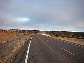
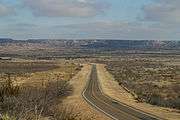
Farm to Market Road 669 (FM 669) is a Farm to Market Road in West Texas. It extends in a northerly direction for 68.8 miles (110.7 km) from Big Spring in Howard County to Post in Garza County.
Beginning at a complex junction with Farm to Market Road 700 and Texas State Highway 350 on the north side of Big Spring, Farm to Market Road 669 initially runs for 15 miles (24 km) in a northerly direction across the level plains of the Llano Estacado, passing numerous cotton fields and rural farm homes. Near the intersection of FM 1785, FM 669 drops off the Caprock and enters the rolling ranch and oil country of Borden County. The undulating, broken land of Borden County was carved by numerous ephemeral tributaries of the upper Colorado River that typically originate as springs along the Caprock Escarpment to the west and generally flow across the county in an easterly direction.[119]
After crossing the Colorado River, about 5 miles (8.0 km) north of the Howard-Borden county line, FM 669 continues north toward Gail, the county seat of Borden County.[120] Near Gail, one passes two prominent erosional remnants of the Llano Estacado. To the south of Gail, one can see a conspicuous landmark known as Mushaway Peak (also known as Muchakooaga, Muchaque Peak or Cordova Peak); this small butte stands on high ground between Grape Creek and Bull Creek, two tributaries of the upper Colorado River.[121] A much larger mesa, called Gail Mountain, stands on the western edge of Gail and provides a scenic backdrop for this small town.[122]
In Gail, FM 669 crosses U.S. Highway 180, which runs west-east from Lamesa to Snyder and beyond. Continuing north, FM 669 draws closer to the edge of the Llano Estacado, which can be seen 5 miles (8.0 km) to the west. Approximately 6 miles (9.7 km) north of Gail is a junction with FM 2350, which leads to Fluvanna and the Brazos Wind Ranch, to the east.
Farther north, near the Borden-Garza county line, FM 669 reaches a high point that divides the drainage of the upper Brazos and Colorado rivers. Along this drainage divide, the land is highly denuded with many small buttes and hoodoos. Less than a mile north of the county line is a historical marker that describes an archaeological site where the "Garza Point" was first identified. These distinctive arrowheads were constructed from local flint, chert, and obsidian by Native Americans living and hunting in this area around A.D. 1440 to 1500.[123]
Around 5 miles (8.0 km) north of the Borden-Garza county line, FM 669 crosses the Double Mountain Fork, a major tributary of the upper Brazos River.[124] From the colorful sandy bed of the Double Mountain Fork, FM 669 climbs 450 feet (140 m) over a distance of 6 miles (9.7 km) as it ascends the Caprock to the high plains of the Llano Estacado. FM 669 remains on the level plains for a short distance of only 3 miles (4.8 km) before suddenly dropping off the Caprock and descending 200 feet (61 m) back to the rolling plains and to the town of Post, the county seat of Garza County. Within the city limits of Post, FM 669 terminates at a junction with U.S. Route 380.[125]
FM 669 was designated in 1945 from US 180 at Gail south 10 miles. On March 30, 1949, FM 669 extended south 2.5 miles to a county road. On November 20, 1951, FM 669 extended to FM 1584 at Vealmoor. On May 5, 1952, FM 669 extended to US 87, replacing FM 1857 on this route. On October 27, 1953, the section of FM 669 from FM 1785 to US 87 was transferred to FM 1785. FM 669 instead extended south to SH 350 near Big Spring, replacing FM 817 from SH 350 to the Borden County Line. On November 21, 1956, FM 669 extended north to FM 1313. On May 1, 1965, the section of FM 1313 from FM 669 to US 380 was transferred to FM 669.
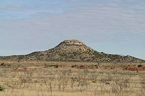 Mushaway Peak, Borden County.
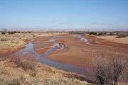
 Farm to Market Road 669, Garza County.
- Junction list
| County | Location | mi[126] | km | Destinations | Notes |
|---|---|---|---|---|---|
| Howard | | 0.0 | 0.0 | ||
| | 10.8 | 17.4 | South end of FM 846 overlap | ||
| | 11.7 | 18.8 | North end of FM 846 overlap | ||
| Borden | | 18.9 | 30.4 | ||
| Gail | 37.1 | 59.7 | |||
| | 44.4 | 71.5 | |||
| Garza | | 65.7 | 105.7 | ||
| Post | 68.8 | 110.7 | |||
1.000 mi = 1.609 km; 1.000 km = 0.621 mi
| |||||
FM 670
| |
|---|---|
| Location | Mitchell County |
| Length | 15.227 mi[127] (24.505 km) |
| Existed | 1945[127]–present |
FM 671
| |
|---|---|
| Location | Caldwell County |
| Length | 7.779 mi[128] (12.519 km) |
| Existed | 1945[128]–present |
FM 672
| |
|---|---|
| Location | Caldwell and Bastrop counties |
| Length | 13.256 mi[129] (21.333 km) |
| Existed | 1945[129]–present |
FM 673
| |
|---|---|
| Location | Bee County |
| Length | 26.118 mi[130] (42.033 km) |
| Existed | 1945[130]–present |
FM 674
| |
|---|---|
| Location | Edwards and Kinney counties |
| Existed | October 24, 1945–October 17, 1959 |
RM 674
| |
|---|---|
| Location | Edwards and Kinney counties |
| Length | 56.436 mi[131] (90.825 km) |
| Existed | October 17, 1959[131]–present |
FM 675
| |
|---|---|
| Location | Cameron County |
| Length | 4.168 mi[132] (6.708 km) |
| Existed | 1945[132]–present |
FM 676
| |
|---|---|
| Location | Hidalgo County |
| Length | 6.889 mi[133] (11.087 km) |
| Existed | 1945[133]–present |
The Alton bus crash occurred along FM 676 in Alton, Texas on September 21, 1989.[134]
FM 677
| |
|---|---|
| Location | Montague County |
| Length | 30.395 mi[135] (48.916 km) |
| Existed | 1946–present |
Farm to Market Road 677 (FM 677) is a farm to market road in Montague County, Texas.[135]
FM 677 is one of the longest farm to market roads in Montague County, and is a two-lane route for its entire length. It begins in Forestburg at a junction with FM 477.[136] It travels northward through the rural eastern part of the county, reaching St. Jo and an intersection with US 82. It continues northward, through the unincorporated communities of Capps Corner and Illinois Bend, close to the Cooke County line.[137] It briefly turns to the west before resuming its northward journey toward the Red River. The FM 677 designation ends as the route crosses into Love County, Oklahoma across the Taovoyas Indian Bridge; the roadway continues as Oklahoma State Highway 89.[135]
A spur of FM 677 exists in Illinois Bend, traveling northward from mainline FM 677 approximately 0.268 mi (0.431 km). It is signed as Spur 677 using the traditional state highway spur marker.[135]
FM 677 was designated on January 31, 1946 northward from US 82 in St. Jo approximately 5.3 mi (8.5 km). It was extended north 2.5 miles on May 23, 1951, south 2.9 miles on November 20, 1951, and again southward on December 17, 1952, to Hardy near the FM 1630 intersection.[138] The route's designation was extended further northward to 3 miles north of Capps Corner on December 2, 1953 and to Illinois Bend on September 29, 1954; the same day also so the lengthening to Forestburg. The connection to the Red River was made on April 24, 1958, and the concurrency with US 82 in St. Jo was removed on June 30, 1961. The connection to Oklahoma was made on December 20, 1988. A spur connection was added on April 25, 1996.[135]
While the designation file indicates that the route enters Cooke County, this contradicts the information in TxDOT's planning file.[135][137]
FM 678
| |
|---|---|
| Location | Cooke County |
| Length | 23.743 mi[139] (38.211 km) |
| Existed | 1945[139]–present |
FM 679
| |
|---|---|
| Location | Comanche and Eastland counties |
| Length | 7.161 mi[140] (11.525 km) |
| Existed | April 23, 1958[140]–present |
FM 679 (1946)
| |
|---|---|
| Location | Randall County |
| Existed | February 21, 1946–December 14, 1956 |
The first FM 679 was designated on February 21, 1946 from US 60 at Umbarger south to Buffalo Lake. On October 25, 1947 the northern terminus was moved to a county road north of US 60 (now FM 1062). On SEptember 21,, 1955 the road was extended south 3.8 miles along Buffalo Lake. FM 679 was cancelled on December 14, 1956 and transferred to FM 168.
FM 680
| |
|---|---|
| Location | Hardeman County |
| Length | 16.787 mi[141] (27.016 km) |
| Existed | May 23, 1951[141]–present |
FM 680 (1946)
| |
|---|---|
| Location | Randall County |
| Existed | February 21, 1946–April 11, 1946 |
The first FM 680 was designated on February 21, 1946 as an extension of Georgia Street in Amarillo, from the Potter County Line south to US 87. Two months later FM 680 was cancelled and transferred to FM 286.
FM 681
| |
|---|---|
| Location | Hidalgo County |
| Length | 29.048 mi[142] (46.748 km) |
| Existed | 1946[142]–present |
FM 682
| |
|---|---|
| Location | DeWitt and Victoria counties |
| Length | 19.224 mi[143] (30.938 km) |
| Existed | 1946[143]–present |
FM 683
| |
|---|---|
| Location | Carson County |
| Length | 6.235 mi[144] (10.034 km) |
| Existed | 1946[144]–present |
FM 684
| |
|---|---|
| Location | Floyd and Motley counties |
| Length | 17.868 mi[145] (28.756 km) |
| Existed | May 23, 1951[145]–present |
FM 684 (1946)
| |
|---|---|
| Location | Dallas County |
| Existed | February 23, 1946–August 8, 1946 |
The first FM 684 was designated on February 23, 1946 from US 80 near the triple overpass at Dallas to Irving and then on to Loop 183 close to where Belt Line Road intersects SH 183 near the Dallas/Tarrant County line. Two months later FM 684 was cancelled and reassigned to SH 356.
FM 685
| |
|---|---|
| Location | Travis and Williamson Counties |
| Length | 4.392 mi[146][nb 5] (7.068 km) |
| Existed | 1946–present |
Farm to Market Road 685 (FM 685) is a farm to market road in Greater Austin, Texas.[146]
FM 685 begins in Pflugerville at the northern terminus of Dessau Road and at the eastern terminus of FM 1825.[34] The route runs to the northeast through Pflugerville to an interchange with the SH 45 Toll / SH 130 Toll toll road. From here, FM 685 runs north along the frontage road of the toll road, before separating from SH 130 in southern Hutto. The route continues to the northeast before ending at a junction with US 79 in central Hutto.[35]
FM 685 was designated in Williamson County on May 15, 1946 on an existing roadway, running from US 79 at Hutto southward to the Travis County line. The designation was extended into Travis County and Pflugerville on December 17, 1952, to its current southern terminus at FM 1825.[146]
When the SH 130 toll road was constructed, the segment between Pflugerville and Hutto used the right-of-way of FM 685. The FM 685 designation was subsequently applied to the frontage roads of the toll road.
- Junction list
| County | Location | mi[147] | km | Destinations | Notes |
|---|---|---|---|---|---|
| Travis | Pflugerville | 0.0 | 0.0 | ||
| 2.3 | 3.7 | SH 130 exit 428A | |||
| 2.9 | 4.7 | ||||
| Williamson | | 6.0 | 9.7 | SH 130 exit 426/425 | |
| Hutto | 8.0 | 12.9 | |||
| 1.000 mi = 1.609 km; 1.000 km = 0.621 mi | |||||
FM 686
| |
|---|---|
| Location | Liberty County |
| Length | 11.943 mi[148] (19.220 km) |
| Existed | 1946[148]–present |
RM 687
| |
|---|---|
| Location | Hutchinson County |
| Length | 18.506 mi[149] (29.783 km) |
| Existed | 1946[149]–present |
FM 688
| |
|---|---|
| Location | Forney |
| Length | 2.313 mi[150] (3.722 km) |
| Existed | January 18, 1960–present |
FM 688 runs through Forney along an old routing of U.S. Route 80. The highway begins at an interchange with US 80 and ends at an intersection with Farm to Market Road 548. The road is known locally as Broad Street. It was designated on January 18, 1960 on its current route.
- Major intersections
The entire route is in Forney, Kaufman County.
| mi[151] | km | Destinations | Notes | ||
|---|---|---|---|---|---|
| 0.0 | 0.0 | Traffic must travel to FM 460 to access US 80 | |||
| 0.6 | 0.97 | West end of FM 740 overlap | |||
| 0.9 | 1.4 | East end of FM 740 overlap | |||
| 2.3 | 3.7 | ||||
1.000 mi = 1.609 km; 1.000 km = 0.621 mi
| |||||
FM 688 (1946)
| |
|---|---|
| Location | Taylor County |
| Existed | May 15, 1946–November 27, 1957 |
The first FM 688 was designated on May 15, 1946 from US 84 at Lawn to US 83 at Ovalo. On December 16, 1948 the section from Lawn to the Callahan County line was added. On July 11, 1951 the section from Lawn to the Callahan County line was transferred to FM 604, and a 1.6 mile section was also transferred to FM 604 on February 20, 1952. On November 27, 1957 the remainder of FM 688 was cancelled and transferred to FM 382.
FM 689
| |
|---|---|
| Location | Floyd County |
| Length | 16.208 mi[152] (26.084 km) |
| Existed | June 26, 1996[152]–present |
FM 689 (1946)
| |
|---|---|
| Location | Kerr, Bandera and Medina counties |
| Existed | June 4, 1946–August 29, 1990 |
The first FM 689 was designated on June 4, 1946 from PR 19 inside Kerrville State Park (now Kerrville-Schreiner Park) south through Camp Verde to Bandera in substitution for RM 481. On April 27, 1948 the road was extended to SH 16, replacing a portion of PR 19. On October 28, 1953 the road was extended 18.8 miles south of Bandera, creating a concurrency with SH 16. On December 15, 1954 the road was extended 8.3 miles south to US 90. On February 1, 1972, FM 689 was signed, but not designated, as SH 173.[153] On November 15, 1978 the section of FM 689 from SH 16 to PR 19 was transferred to Loop 534 (but still signed as SH 173).[154][155] FM 689 was cancelled on August 29, 1990 as the extension of SH 173 over this road was officially designated.[156]
RM 690
| |
|---|---|
| Location | Burnet County |
| Length | 5.719 mi[157] (9.204 km) |
| Existed | June 1, 1965–present |
FM 690 (1946)
| |
|---|---|
| Location | Parmer County |
| Existed | May 29, 1945–November 21, 1957 |
FM 690 was designated on May 29, 1945 from US 84, 2 miles east of Farwell, to Oklahoma Lane School. On December 16, 1948 the road was extended east 10 miles via Midway School to a road intersection. On July 7, 1951 the connection to Oklahoma Lane School was cancelled and became a portion of FM 1731. On October 29, 1953 the road was extended 6.6 miles to 1 mile east of Lazbuddie. On April 24, 1954 the road was extended another 2 miles east. FM 690 was cancelled on November 21, 1957 and transferred to FM 145, although the US 84-FM 299 section remained signed as FM 690 until 1958.
FM 691
| |
|---|---|
| Location | Grayson County |
| Length | 5.302 mi[158] (8.533 km) |
| Existed | 1946[158]–present |
Farm to Market Road 691 (or FM 691) is located in Grayson County. The highway is known locally as Grayson Drive in the Sherman–Denison metropolitan area.
FM 691 begins at an intersection with Perimeter Road near North Texas Regional Airport in Sherman and has an intersection with FM 1417 just east of here. The highway passes Grayson College before sharing an overlap with FM 131. FM 691 straddles the Sherman-Denison line and crosses US 75 before ending at an intersection with SH 91.
FM 691 was designated on April 16, 1946 from Camp Perrin to US 75 (now SH 91). On June 27, 1995 the entire highway was internally designated as Urban Road 691 by TxDOT.[159]
- Junction list
The entire route is in Grayson County.
| Location | mi[160] | km | Destinations | Notes | |
|---|---|---|---|---|---|
| | 0.0 | 0.0 | Perimeter Road, Grayson Drive – North Texas Regional Airport | Western terminus; continues west as Grayson Drive | |
| Sherman | 0.5 | 0.80 | Continues west as Grayson Drive | ||
| | 2.1 | 3.4 | West end of FM 131 overlap | ||
| | 3.3 | 5.3 | East end of FM 131 overlap | ||
| Sherman–Denison line | 4.1 | 6.6 | US 75 exit 65 | ||
| Denison | 5.3 | 8.5 | Eastern terminus | ||
1.000 mi = 1.609 km; 1.000 km = 0.621 mi
| |||||
FM 692
| |
|---|---|
| Location | Newton County |
| Length | 15.063 mi[161] (24.242 km) |
| Existed | May 23, 1951[161]–present |
Farm to Market Road 692 (FM 692) is a 15.063-mile (24.242 km) farm to market road located in Newton County, Texas.[161] The route runs from Texas State Highway 63 in Burkeville north to Louisiana Highway 191 at the Louisiana state line north of South Toledo Bend. FM 692 is maintained by the Texas Department of Transportation.
FM 692 begins at a junction with State Highway 63 in Burkeville. From here, the highway heads north a rural area. The route then turns to the northeast, following a twisting route through farmland. After turning north again, the road crosses three creeks and passes Gunter Cemetery.[162] The highway then reaches a junction with Texas Recreational Road 255 in South Toledo Bend. After passing Texas State Highway Spur 135 north of that junction, FM 692 crosses a channel connecting the Toledo Bend Reservoir to the Sabine River and heads north alongside the Toledo Bend Dam. FM 692 ends at the Louisiana border while along the dam; the road continues into Louisiana as Highway 191.[163][164]
On May 23, 1951, FM 692 was designated along part of its current route, 2.8 miles (4.5 km) from State Highway 63 northward. The highway was extended 2.8 more miles on November 20, 1951.
On September 27, 1960, FM 692 was extended north 6.6 miles. On September 20, 1961, FM 652 extended north 1.4 miles. On MAy 6, 1964, it extended north 0.8 miles. On August 26, 1969, FM 692 extended to the Louisiana State Line, which brought the route to its current length. FM 692 has not changed its route since its 1969 expansion.[161]
FM 692 (1946)
| |
|---|---|
| Location | Nueces County |
| Existed | June 4, 1946[161]–September 5, 1946 |
The original FM 692 was designated on June 4, 1946 from FM 665 southwest of Corpus Christi southeast 9.3 miles, then northeast to FM 693 (now SH 358). FM 692 was cancelled three months later and reassigned to SH 357.
RM 693
| |
|---|---|
| Location | Kinney County |
| Length | 18.571 mi[165] (29.887 km) |
| Existed | May 23, 1951[165][nb 6]–present |
Ranch to Market Road 693 (RM 693) is a 18.571 mi (29.887 km) farm-to-market road in southwest Kinney County, Texas.[165] The southern terminus is at US 277.[166] RM 693 travels northeast through unincorporated Kinney County before ending at a junction with US 90 west of Brackettville.[165][167]
FM 693 was designated on May 23, 1951, from US 90 southwestward 7.6 miles. On November 20, 1951, FM 693 was extended to US 277. The designation was changed from an FM to an RM on October 17, 1959.
FM 693 (1946)
| |
|---|---|
| Location | Nueces County |
| Existed | June 4, 1946[165]–September 5, 1946 |
The original FM 693 was designated on June 4, 1946 from SH 286 south of Corpus Christi southeast to Corpus Christi NAS. FM 693 was cancelled three months later and reassigned to SH 358.
FM 694
| |
|---|---|
| Location | Hartley County |
| Length | 12.599 mi[168] (20.276 km) |
| Existed | 1946[168]–present |
FM 695
| |
|---|---|
| Location | Dallam County |
| Length | 3.324 mi[169] (5.349 km) |
| Existed | 1946[169]–present |
FM 696
| |
|---|---|
| Location | Bastrop, Lee and Burleson counties |
| Length | 35.485 mi[170] (57.108 km) |
| Existed | 1946[170]–present |
Farm to Market Road 696 (FM 696) is located in Bastrop, Lee and Burleson counties.[33]
FM 696 was designated on Jul 31, 1946, from SH 20 (now US 290) northeast 1.1 miles to Butler. On November 23, 1948, FM 696 was extended northeast to the Bastrop-Lee county line, and another section from Blue in Lee County east to FM 112 was added, creating a gap. On July 14, 1949, FM 696 extended from the Bastrop-Lee county line to Blue, closing the gap. On September 27, 1960, FM 696 extended east to a road intersection 6 miles east of US 77, replacing a section of FM 112. On June 11, 1965, FM 696 extended southeast to SH 21, replacing FM 1574.
FM 697
| |
|---|---|
| Location | Grayson County |
| Length | 14.794 mi[171] (23.809 km) |
| Existed | 1946[171]–present |
FM 698
| |
|---|---|
| Location | Nacogdoches County |
| Length | 6.682 mi[172] (10.754 km) |
| Existed | 1946[172]–present |
FM 699
| |
|---|---|
| Location | Panola and Shelby counties |
| Length | 30.169 mi[173] (48.552 km) |
| Existed | 1946[173]–present |
Notes
- ↑ The certified length given is shorter than the actual mileage, as the TxDOT description of FM 600 considers it to be discontinuous at rather than concurrent with SH 6 and FM 618.
- ↑ The certified length given is shorter than the actual mileage, as the TxDOT description of FM 649 considers it to be discontinuous at rather than concurrent with SH 16.
- ↑ The certified length given is shorter than the actual mileage, as the TxDOT description of FM 659 considers it to be discontinuous at Loop 375.
- ↑ Although traveling west–east from Ovilla to Ferris, the route is signed south–north.
- ↑ The certified length given is shorter than the actual mileage, as the TxDOT description of FM 685 considers it to be discontinuous at SH 130.
- ↑ RM 693 was previously designated as FM 693 from 1951 to 1959.
References
- 1 2 Transportation Planning and Programming Division (n.d.). "Farm to Market Road No. 600". Highway Designation Files. Texas Department of Transportation. Retrieved 2015-11-16.
- ↑ Transportation Planning and Programming Division (n.d.). "Farm to Market Road No. 1834". Highway Designation Files. Texas Department of Transportation. Retrieved September 12, 2017.
- ↑ Transportation Planning and Programming Division (n.d.). "Farm to Market Road No. 1193". Highway Designation Files. Texas Department of Transportation. Retrieved September 12, 2017.
- ↑ Transportation Planning and Programming Division (n.d.). "Farm to Market Road No. 142". Highway Designation Files. Texas Department of Transportation. Retrieved September 12, 2017.
- ↑ Transportation Planning and Programming Division (n.d.). "Urban Road No. 600". Highway Designation Files. Texas Department of Transportation. Retrieved September 12, 2017.
- ↑ Google (September 12, 2017). "Overview Map of FM 600" (Map). Google Maps. Google. Retrieved September 12, 2017.
- 1 2 Transportation Planning and Programming Division (n.d.). "Farm to Market Road No. 601". Highway Designation Files. Texas Department of Transportation. Retrieved 2015-11-16.
- 1 2 3 Transportation Planning and Programming Division (n.d.). "Farm to Market Road No. 602". Highway Designation Files. Texas Department of Transportation. Retrieved 2015-11-15.
- 1 2 3 4 Transportation Planning and Programming Division (n.d.). "Farm to Market Road No. 603". Highway Designation Files. Texas Department of Transportation. Retrieved 2015-11-15.
- ↑ Transportation Planning and Programming Division (2012). Texas County Mapbook (PDF) (Map) (2012 ed.). 1:120,000. Texas Department of Transportation. p. 335. OCLC 867856197. Retrieved 2011-09-29.
- ↑ Transportation Planning and Programming Division (2012). Texas County Mapbook (PDF) (Map) (2012 ed.). 1:120,000. Texas Department of Transportation. p. 334. OCLC 867856197. Retrieved 2011-09-29.
- ↑ Transportation Planning and Programming Division (n.d.). "Farm to Market Road No. 18". Highway Designation Files. Texas Department of Transportation. Retrieved 2011-09-29.
- 1 2 Transportation Planning and Programming Division (n.d.). "Farm to Market Road No. 604". Highway Designation Files. Texas Department of Transportation. Retrieved 2015-11-16.
- 1 2 Transportation Planning and Programming Division (n.d.). "Farm to Market Road No. 605". Highway Designation Files. Texas Department of Transportation. Retrieved 2015-11-16.
- 1 2 3 Transportation Planning and Programming Division (n.d.). "Farm to Market Road No. 606". Highway Designation Files. Texas Department of Transportation. Retrieved October 3, 2012.
- ↑ Statewide Planning Map (Map). Cartography by Transportation Planning and Programming Division. Texas Department of Transportation. 2012. Archived from the original on October 23, 2012. Retrieved October 3, 2012.
- ↑ Charles, Thomas (April 29, 2012). "Where to Fish in Port Mansfield, Texas?". Livestrong.com. Retrieved October 3, 2012.
- ↑ Google (2012-03-12). "Overview map of Farm to Market Road 606 Distances Between Interchanges" (Map). Google Maps. Google. Retrieved 2012-03-12.
- ↑ Transportation Planning and Programming Division (2012). Texas County Mapbook (PDF) (Map) (2012 ed.). 1:120,000. Texas Department of Transportation. p. 475. OCLC 867856197. Retrieved October 3, 2012.
- 1 2 3 Transportation Planning and Programming Division (n.d.). "Farm to Market Road No. 607". Highway Designation Files. Texas Department of Transportation. Retrieved 2015-11-16.
- ↑ Transportation Planning and Programming Division (n.d.). "Farm to Market Road No. 314". Highway Designation Files. Texas Department of Transportation. Retrieved 2015-11-16.
- 1 2 Transportation Planning and Programming Division (n.d.). "Farm to Market Road No. 608". Highway Designation Files. Texas Department of Transportation. Retrieved 2015-11-16.
- 1 2 3 Transportation Planning and Programming Division (n.d.). "Farm to Market Road No. 609". Highway Designation Files. Texas Department of Transportation. Retrieved 2015-11-16.
- 1 2 Transportation Planning and Programming Division (n.d.). "Farm to Market Road No. 610". Highway Designation Files. Texas Department of Transportation. Retrieved 2015-11-16.
- 1 2 Transportation Planning and Programming Division (n.d.). "Farm to Market Road No. 611". Highway Designation Files. Texas Department of Transportation. Retrieved 2015-11-16.
- 1 2 Transportation Planning and Programming Division (n.d.). "Farm to Market Road No. 612". Highway Designation Files. Texas Department of Transportation. Retrieved 2015-11-16.
- 1 2 Transportation Planning and Programming Division (n.d.). "Farm to Market Road No. 613". Highway Designation Files. Texas Department of Transportation. Retrieved 2015-11-16.
- 1 2 Transportation Planning and Programming Division (n.d.). "Farm to Market Road No. 614". Highway Designation Files. Texas Department of Transportation. Retrieved 2015-11-16.
- 1 2 3 Transportation Planning and Programming Division (n.d.). "Farm to Market Road No. 615". Highway Designation Files. Texas Department of Transportation. Retrieved 2015-11-16.
- 1 2 Transportation Planning and Programming Division (n.d.). "Farm to Market Road No. 616". Highway Designation Files. Texas Department of Transportation. Retrieved 2015-11-15.
- 1 2 Transportation Planning and Programming Division (n.d.). "Farm to Market Road No. 617". Highway Designation Files. Texas Department of Transportation. Retrieved 2015-11-16.
- 1 2 Transportation Planning and Programming Division (n.d.). "Farm to Market Road No. 618". Highway Designation Files. Texas Department of Transportation. Retrieved 2015-11-16.
- 1 2 3 4 5 6 7 Transportation Planning and Programming Division (n.d.). "Farm to Market Road No. 619". Highway Designation Files. Texas Department of Transportation. Retrieved 2015-11-15.
- 1 2 Transportation Planning and Programming Division (2012). Texas County Mapbook (PDF) (Map) (2012 ed.). 1:120,000. Texas Department of Transportation. p. 461. OCLC 867856197. Retrieved 2011-09-28.
- 1 2 Transportation Planning and Programming Division (2012). Texas County Mapbook (PDF) (Map) (2012 ed.). 1:120,000. Texas Department of Transportation. p. 460. OCLC 867856197. Retrieved 2011-09-28.
- 1 2 Transportation Planning and Programming Division (n.d.). "Ranch to Market Road No. 620". Highway Designation Files. Texas Department of Transportation. Retrieved 2015-11-15.
- 1 2 Transportation Planning and Programming Division (n.d.). "Farm to Market Road No. 621". Highway Designation Files. Texas Department of Transportation. Retrieved 2015-11-16.
- 1 2 Transportation Planning and Programming Division (n.d.). "Farm to Market Road No. 622". Highway Designation Files. Texas Department of Transportation. Retrieved 2015-11-16.
- 1 2 Transportation Planning and Programming Division (n.d.). "Farm to Market Road No. 623". Highway Designation Files. Texas Department of Transportation. Retrieved 2015-11-16.
- 1 2 Transportation Planning and Programming Division (n.d.). "Farm to Market Road No. 624". Highway Designation Files. Texas Department of Transportation. Retrieved 2015-11-16.
- 1 2 Transportation Planning and Programming Division (n.d.). "Farm to Market Road No. 625". Highway Designation Files. Texas Department of Transportation. Retrieved 2015-11-16.
- 1 2 Transportation Planning and Programming Division (n.d.). "Farm to Market Road No. 626". Highway Designation Files. Texas Department of Transportation. Retrieved 2015-11-16.
- 1 2 Transportation Planning and Programming Division (n.d.). "Farm to Market Road No. 627". Highway Designation Files. Texas Department of Transportation. Retrieved 2015-11-16.
- ↑ (PDF) https://publicdocs.txdot.gov/minord/MinuteOrderDocLib/003676474.pdf. Missing or empty
|title=(help) - 1 2 Transportation Planning and Programming Division (n.d.). "Ranch to Market Road No. 628". Highway Designation Files. Texas Department of Transportation. Retrieved 2015-11-16.
- 1 2 Transportation Planning and Programming Division (n.d.). "Farm to Market Road No. 629". Highway Designation Files. Texas Department of Transportation. Retrieved 2015-11-16.
- 1 2 Transportation Planning and Programming Division (n.d.). "Farm to Market Road No. 630". Highway Designation Files. Texas Department of Transportation. Retrieved 2015-11-16.
- 1 2 Transportation Planning and Programming Division (n.d.). "Farm to Market Road No. 631". Highway Designation Files. Texas Department of Transportation. Retrieved 2015-11-16.
- 1 2 3 4 5 6 Transportation Planning and Programming Division (n.d.). "Farm to Market Road No. 632". Highway Designation Files. Texas Department of Transportation. Retrieved 2016-04-27.
- 1 2 Transportation Planning and Programming Division (n.d.). "Farm to Market Road No. 633". Highway Designation Files. Texas Department of Transportation. Retrieved 2015-11-18.
- 1 2 3 Transportation Planning and Programming Division (n.d.). "Farm to Market Road No. 634". Highway Designation Files. Texas Department of Transportation. Retrieved 2015-01-05.
- 1 2 Transportation Planning and Programming Division (n.d.). "Farm to Market Road No. 635". Highway Designation Files. Texas Department of Transportation. Retrieved 2015-11-18.
- 1 2 Transportation Planning and Programming Division (n.d.). "Farm to Market Road No. 636". Highway Designation Files. Texas Department of Transportation. Retrieved 2015-11-18.
- 1 2 Transportation Planning and Programming Division (n.d.). "Farm to Market Road No. 637". Highway Designation Files. Texas Department of Transportation. Retrieved 2015-11-18.
- 1 2 Transportation Planning and Programming Division (n.d.). "Farm to Market Road No. 638". Highway Designation Files. Texas Department of Transportation. Retrieved 2015-11-18.
- 1 2 Transportation Planning and Programming Division (n.d.). "Farm to Market Road No. 639". Highway Designation Files. Texas Department of Transportation. Retrieved 2015-11-18.
- 1 2 3 4 Transportation Planning and Programming Division (n.d.). "Farm to Market Road No. 640". Highway Designation Files. Texas Department of Transportation. Retrieved 2015-11-18.
- 1 2 3 Google (June 9, 2013). "List of Farm to Market Roads in Texas (600–699)" (Map). Google Maps. Google. Retrieved June 9, 2013.
- 1 2 1953 Glen Flora 7.5' quad
- ↑ 1952 Egypt 7.5' quad
- 1 2 Transportation Planning and Programming Division (n.d.). "Farm to Market Road No. 641". Highway Designation Files. Texas Department of Transportation. Retrieved 2015-11-18.
- 1 2 Transportation Planning and Programming Division (n.d.). "Farm to Market Road No. 642". Highway Designation Files. Texas Department of Transportation. Retrieved 2015-11-18.
- ↑ Transportation Planning and Programming Division (n.d.). "Farm to Market Road No. 643". Highway Designation Files. Texas Department of Transportation. Retrieved 2015-11-18.
- 1 2 Transportation Planning and Programming Division (n.d.). "Farm to Market Road No. 544". Highway Designation Files. Texas Department of Transportation. Retrieved 2015-11-18.
- 1 2 3 Transportation Planning and Programming Division (n.d.). "Farm to Market Road No. 645". Highway Designation Files. Texas Department of Transportation. Retrieved 2015-11-18.
- 1 2 3 4 Transportation Planning and Programming Division (n.d.). "Farm to Market Road No. 646". Highway Designation Files. Texas Department of Transportation. Retrieved 2015-11-15.
- ↑ Transportation Planning and Programming Division (n.d.). "Farm to Market Road No. 517". Highway Designation Files. Texas Department of Transportation. Retrieved September 2, 2011.
- ↑ Transportation Planning and Programming Division (n.d.). "Farm to Market Road No. 520". Highway Designation Files. Texas Department of Transportation. Retrieved September 2, 2011.
- 1 2 Transportation Planning and Programming Division (n.d.). "Farm to Market Road No. 647". Highway Designation Files. Texas Department of Transportation. Retrieved August 1, 2017.
- 1 2 Transportation Planning and Programming Division (n.d.). "Ranch to Market Road No. 648". Highway Designation Files. Texas Department of Transportation. Retrieved August 1, 2017.
- 1 2 3 4 5 Transportation Planning and Programming Division (n.d.). "Farm to Market Road No. 649". Highway Designation Files. Texas Department of Transportation. Retrieved 2011-09-29.
- ↑ Transportation Planning and Programming Division (2012). Texas County Mapbook (PDF) (Map) (2012 ed.). 1:120,000. Texas Department of Transportation. p. 385. OCLC 867856197. Retrieved 2011-09-29.
- ↑ Transportation Planning and Programming Division (2012). Texas County Mapbook (PDF) (Map) (2012 ed.). 1:120,000. Texas Department of Transportation. p. 384. OCLC 867856197. Retrieved 2011-09-29.
- ↑ Transportation Planning and Programming Division (2012). Texas County Mapbook (PDF) (Map) (2012 ed.). 1:120,000. Texas Department of Transportation. p. 383. OCLC 867856197. Retrieved 2011-09-29.
- ↑ Transportation Planning and Programming Division (2012). Texas County Mapbook (PDF) (Map) (2012 ed.). 1:120,000. Texas Department of Transportation. p. 382. OCLC 867856197. Retrieved 2011-09-29.
- ↑ Transportation Planning and Programming Division (n.d.). "Farm to Market Road No. 496". Highway Designation Files. Texas Department of Transportation. Retrieved 2011-09-29.
- ↑ Transportation Planning and Programming Division (n.d.). "U.S. Highway No. 59". Highway Designation Files. Texas Department of Transportation. Retrieved 2011-09-29.
- 1 2 Transportation Planning and Programming Division (n.d.). "Farm to Market Road No. 650". Highway Designation Files. Texas Department of Transportation. Retrieved August 1, 2017.
- 1 2 Transportation Planning and Programming Division (n.d.). "Farm to Market Road No. 651". Highway Designation Files. Texas Department of Transportation. Retrieved September 30, 2016.
- 1 2 3 Transportation Planning and Programming Division (n.d.). "Ranch to Market Road No. 652". Highway Designation Files. Texas Department of Transportation. Retrieved 2011-09-21.
- ↑ Transportation Planning and Programming Division (2012). Texas County Mapbook (PDF) (Map) (2012 ed.). 1:120,000. Texas Department of Transportation. p. 92. OCLC 867856197. Retrieved 2011-09-21.
- ↑ Transportation Planning and Programming Division (2012). Texas County Mapbook (PDF) (Map) (2012 ed.). 1:120,000. Texas Department of Transportation. p. 102. OCLC 867856197. Retrieved 2011-09-21.
- 1 2 Transportation Planning and Programming Division (n.d.). "Farm to Market Road No. 653". Highway Designation Files. Texas Department of Transportation. Retrieved August 1, 2017.
- ↑ Transportation Planning and Programming Division (n.d.). "Farm to Market Road No. 654". Highway Designation Files. Texas Department of Transportation. Retrieved August 1, 2017.
- 1 2 3 4 Transportation Planning and Programming Division (n.d.). "Farm to Market Road No. 655". Highway Designation Files. Texas Department of Transportation. Retrieved October 27, 2011.
- ↑ Google (October 27, 2011). "overview of Farm to Market Road 655" (Map). Google Maps. Google. Retrieved October 27, 2011.
- ↑ County Grid Map 564 (PDF) (Map). Texas Department of Transportation. 2010. Retrieved October 27, 2011.
- 1 2 Transportation Planning and Programming Division (n.d.). "Farm to Market Road No. 656". Highway Designation Files. Texas Department of Transportation. Retrieved August 1, 2017.
- 1 2 Transportation Planning and Programming Division (n.d.). "Farm to Market Road No. 657". Highway Designation Files. Texas Department of Transportation. Retrieved August 1, 2017.
- 1 2 Transportation Planning and Programming Division (n.d.). "Farm to Market Road No. 658". Highway Designation Files. Texas Department of Transportation. Retrieved August 1, 2017.
- ↑ Transportation Planning and Programming Division (n.d.). "Farm to Market Road No. 659". Highway Designation Files. Texas Department of Transportation. Retrieved July 3, 2017.
- ↑ Transportation Planning and Programming Division (n.d.). "Urban Road No. 659". Highway Designation Files. Texas Department of Transportation. Retrieved July 3, 2017.
- ↑ Google (July 3, 2017). "Overview Map of FM 659" (Map). Google Maps. Google. Retrieved July 3, 2017.
- 1 2 3 Transportation Planning and Programming Division (n.d.). "Farm to Market Road No. 660". Highway Designation Files. Texas Department of Transportation. Retrieved August 14, 2016.
- 1 2 Transportation Planning and Programming Division (n.d.). "Farm to Market Road No. 661". Highway Designation Files. Texas Department of Transportation. Retrieved August 1, 2017.
- 1 2 Transportation Planning and Programming Division (n.d.). "Farm to Market Road No. 662". Highway Designation Files. Texas Department of Transportation. Retrieved August 1, 2017.
- ↑ Transportation Planning and Programming Division (n.d.). "Urban Road No. 662". Highway Designation Files. Texas Department of Transportation. Retrieved August 2, 2017.
- 1 2 Transportation Planning and Programming Division (n.d.). "Farm to Market Road No. 663". Highway Designation Files. Texas Department of Transportation. Retrieved August 1, 2017.
- 1 2 3 4 5 Transportation Planning and Programming Division (n.d.). "Farm to Market Road No. 664". Highway Designation Files. Texas Department of Transportation. Retrieved January 6, 2011.
- ↑ Transportation Planning and Programming Division (2014). Texas County Mapbook (PDF) (Map) (2014 ed.). 1:120,000. Texas Department of Transportation. p. 418. Retrieved December 6, 2014.
- ↑ Transportation Planning and Programming Division (n.d.). "State Highway Loop No. 528". Highway Designation Files. Texas Department of Transportation. Retrieved January 7, 2011.
- ↑ "Overview Map of FM 664". Google Maps. Retrieved April 15, 2017.
- 1 2 3 Transportation Planning and Programming Division (n.d.). "Farm to Market Road No. 665". Highway Designation Files. Texas Department of Transportation. Retrieved 2011-01-06.
- ↑ Transportation Planning and Programming Division (2012). Texas County Mapbook (PDF) (Map) (2012 ed.). 1:120,000. Texas Department of Transportation. p. 440. OCLC 867856197. Retrieved 2011-01-06.
- ↑ Transportation Planning and Programming Division (2012). Texas County Mapbook (PDF) (Map) (2012 ed.). 1:120,000. Texas Department of Transportation. p. 441. OCLC 867856197. Retrieved 2011-01-06.
- ↑ Transportation Planning and Programming Division (2012). Texas County Mapbook (PDF) (Map) (2012 ed.). 1:120,000. Texas Department of Transportation. p. 471. OCLC 867856197. Retrieved 2011-01-06.
- ↑ Transportation Planning and Programming Division (2012). Texas County Mapbook (PDF) (Map) (2012 ed.). 1:120,000. Texas Department of Transportation. p. 470. OCLC 867856197. Retrieved 2011-01-06.
- ↑ Transportation Planning and Programming Division (n.d.). "Farm to Market Road No. 666". Highway Designation Files. Texas Department of Transportation. Retrieved 2011-01-06.
- ↑ Transportation Planning and Programming Division (n.d.). "Farm to Market Road No. 736". Highway Designation Files. Texas Department of Transportation. Retrieved 2011-01-06.
- ↑ Transportation Planning and Programming Division (n.d.). "Urban Road No. 665". Highway Designation Files. Texas Department of Transportation. Retrieved 2011-01-06.
- 1 2 3 4 Transportation Planning and Programming Division (n.d.). "Farm to Market Road No. 666". Highway Designation Files. Texas Department of Transportation. Retrieved July 5, 2014.
- ↑ Transportation Planning and Programming Division (2014). Texas County Mapbook (PDF) (Map) (2014 ed.). 1:120,000. Texas Department of Transportation. p. 376. Retrieved December 3, 2014.
- ↑ Transportation Planning and Programming Division (2014). Texas County Mapbook (PDF) (Map) (2014 ed.). 1:120,000. Texas Department of Transportation. p. 375. Retrieved December 3, 2014.
- ↑ Transportation Planning and Programming Division (2014). Texas County Mapbook (PDF) (Map) (2014 ed.). 1:120,000. Texas Department of Transportation. p. 374. Retrieved December 3, 2014.
- ↑ Google (July 3, 2017). "Overview Map of FM 666" (Map). Google Maps. Google. Retrieved July 3, 2017.
- 1 2 Transportation Planning and Programming Division (n.d.). "Farm to Market Road No. 667". Highway Designation Files. Texas Department of Transportation. Retrieved August 1, 2017.
- 1 2 Transportation Planning and Programming Division (n.d.). "Farm to Market Road No. 668". Highway Designation Files. Texas Department of Transportation. Retrieved August 1, 2017.
- 1 2 Transportation Planning and Programming Division (n.d.). "Farm to Market Road No. 669". Highway Designation Files. Texas Department of Transportation.
- ↑ Hunt, William R. & Leffler, John. "Borden County". Handbook of Texas Online. Retrieved February 5, 2011.
- ↑ Hunt, William R. "Gail, TX". Handbook of Texas Online. Retrieved January 31, 2011.
- ↑ Anonymous. "Mushaway Peak". Handbook of Texas Online. Retrieved January 28, 2011.
- ↑ Anonymous. "Gail Mountain". Handbook of Texas Online. Retrieved February 5, 2011.
- ↑ Runkles, Frank A. "Garza Site". Handbook of Texas Online. Retrieved February 4, 2011.
- ↑ Anonymous. "Double Mountain Fork of the Brazos River". Handbook of Texas Online. Retrieved January 29, 2011.
- ↑ Lucko, Paul M. "Post, TX". Handbook of Texas Online. Retrieved January 28, 2011.
- ↑ Google (August 2, 2017). "Overview Map of FM 669" (Map). Google Maps. Google. Retrieved August 2, 2017.
- 1 2 Transportation Planning and Programming Division (n.d.). "Farm to Market Road No. 670". Highway Designation Files. Texas Department of Transportation. Retrieved August 1, 2017.
- 1 2 Transportation Planning and Programming Division (n.d.). "Farm to Market Road No. 671". Highway Designation Files. Texas Department of Transportation. Retrieved August 1, 2017.
- 1 2 Transportation Planning and Programming Division (n.d.). "Farm to Market Road No. 672". Highway Designation Files. Texas Department of Transportation. Retrieved August 1, 2017.
- 1 2 Transportation Planning and Programming Division (n.d.). "Farm to Market Road No. 673". Highway Designation Files. Texas Department of Transportation. Retrieved August 1, 2017.
- 1 2 Transportation Planning and Programming Division (n.d.). "Ranch to Market Road No. 674". Highway Designation Files. Texas Department of Transportation. Retrieved August 1, 2017.
- 1 2 Transportation Planning and Programming Division (n.d.). "Farm to Market Road No. 675". Highway Designation Files. Texas Department of Transportation. Retrieved August 1, 2017.
- 1 2 Transportation Planning and Programming Division (n.d.). "Farm to Market Road No. 676". Highway Designation Files. Texas Department of Transportation. Retrieved August 1, 2017.
- ↑ "Highway Accident Report - Collision between Mission Consolidated Independent School District School Bus and Valley Coca-Cola Bottling Company, Inc. Tractor-Semitrailer Intersection of Bryan Road and Texas Farm-to-Market Road 676 Alton, Texas September 21, 1989" (PDF). National Transportation Safety Board. p. 27 (PDF p. 34/95).
- 1 2 3 4 5 6 Transportation Planning and Programming Division (n.d.). "Farm to Market Road No. 677". Highway Designation Files. Texas Department of Transportation. Retrieved 2011-01-14.
- ↑ Transportation Planning and Programming Division (2012). Texas County Mapbook (PDF) (Map) (2012 ed.). 1:120,000. Texas Department of Transportation. p. 449. OCLC 867856197. Retrieved 2011-01-14.
- 1 2 Transportation Planning and Programming Division (2012). Texas County Mapbook (PDF) (Map) (2012 ed.). 1:120,000. Texas Department of Transportation. p. 448. OCLC 867856197. Retrieved 2011-01-14.
- ↑ Brian Hart. "Hardy, TX". Handbook of Texas Online. Retrieved 2011-01-14.
- 1 2 Transportation Planning and Programming Division (n.d.). "Farm to Market Road No. 678". Highway Designation Files. Texas Department of Transportation. Retrieved August 2, 2017.
- 1 2 Transportation Planning and Programming Division (n.d.). "Farm to Market Road No. 679". Highway Designation Files. Texas Department of Transportation. Retrieved August 2, 2017.
- 1 2 Transportation Planning and Programming Division (n.d.). "Farm to Market Road No. 680". Highway Designation Files. Texas Department of Transportation. Retrieved August 2, 2017.
- 1 2 Transportation Planning and Programming Division (n.d.). "Farm to Market Road No. 681". Highway Designation Files. Texas Department of Transportation. Retrieved August 2, 2017.
- 1 2 Transportation Planning and Programming Division (n.d.). "Farm to Market Road No. 682". Highway Designation Files. Texas Department of Transportation. Retrieved August 2, 2017.
- 1 2 Transportation Planning and Programming Division (n.d.). "Farm to Market Road No. 683". Highway Designation Files. Texas Department of Transportation. Retrieved August 2, 2017.
- 1 2 Transportation Planning and Programming Division (n.d.). "Farm to Market Road No. 684". Highway Designation Files. Texas Department of Transportation. Retrieved August 2, 2017.
- 1 2 3 Transportation Planning and Programming Division (n.d.). "Farm to Market Road No. 685". Highway Designation Files. Texas Department of Transportation. Retrieved 2011-04-07.
- ↑ Google (July 3, 2017). "Overview Map of FM 685" (Map). Google Maps. Google. Retrieved July 3, 2017.
- 1 2 Transportation Planning and Programming Division (n.d.). "Farm to Market Road No. 686". Highway Designation Files. Texas Department of Transportation. Retrieved August 2, 2017.
- 1 2 Transportation Planning and Programming Division (n.d.). "Ranch to Market Road No. 687". Highway Designation Files. Texas Department of Transportation. Retrieved August 2, 2017.
- ↑ Transportation Planning and Programming Division (n.d.). "Farm to Market Road No. 688". Highway Designation Files. Texas Department of Transportation. Retrieved July 26, 2016.
- ↑ "Map of FM 688". Google Maps. Retrieved August 3, 2016.
- 1 2 Transportation Planning and Programming Division (n.d.). "Farm to Market Road No. 689". Highway Designation Files. Texas Department of Transportation. Retrieved July 3, 2017.
- ↑ (PDF) https://publicdocs.txdot.gov/minord/MinuteOrderDocLib/003674251.pdf. Missing or empty
|title=(help) - ↑ (PDF) https://publicdocs.txdot.gov/minord/MinuteOrderDocLib/003674343.pdf. Missing or empty
|title=(help) - ↑ Transportation Planning and Programming Division (n.d.). "State Highway Loop No. 534". Highway Designation Files. Texas Department of Transportation. Retrieved July 3, 2017.
- ↑ Transportation Planning and Programming Division (n.d.). "State Highway No. 173". Highway Designation Files. Texas Department of Transportation. Retrieved July 3, 2017.
- ↑ Transportation Planning and Programming Division (n.d.). "Ranch to Market Road No. 690". Highway Designation Files. Texas Department of Transportation. Retrieved August 2, 2017.
- 1 2 Transportation Planning and Programming Division (n.d.). "Farm to Market Road No. 691". Highway Designation Files. Texas Department of Transportation. Retrieved August 2, 2017.
- ↑ Transportation Planning and Programming Division (n.d.). "Urban Road No. 691". Highway Designation Files. Texas Department of Transportation. Retrieved August 2, 2017.
- ↑ Google (August 2, 2017). "Overview Map of FM 691" (Map). Google Maps. Google. Retrieved August 2, 2017.
- 1 2 3 4 5 Transportation Planning and Programming Division (n.d.). "Farm to Market Road No. 692". Highway Designation Files. Texas Department of Transportation. Retrieved August 12, 2012.
- ↑ Texas County Map Book (Map). Texas Department of Transportation. 2010. p. 616. Archived from the original (PDF) on 2012-08-14. Retrieved August 12, 2012.
- ↑ Texas County Map Book (Map). Texas Department of Transportation. 2010. p. 615. Archived from the original (PDF) on 2012-08-14. Retrieved August 12, 2012.
- ↑ Google (August 12, 2012). "Overview Map of Farm to Market Road 692 - Distances Between Interchanges" (Map). Google Maps. Google. Retrieved August 12, 2012.
- 1 2 3 4 5 Transportation Planning and Programming Division (n.d.). "Ranch to Market Road No. 693". Highway Designation Files. Texas Department of Transportation. Retrieved 2011-01-03.
- ↑ Transportation Planning and Programming Division (2012). Texas County Mapbook (PDF) (Map) (2012 ed.). 1:120,000. Texas Department of Transportation. p. 259. OCLC 867856197. Retrieved 2011-01-06.
- ↑ Transportation Planning and Programming Division (2012). Texas County Mapbook (PDF) (Map) (2012 ed.). 1:120,000. Texas Department of Transportation. p. 288. OCLC 867856197. Retrieved 2011-01-06.
- 1 2 Transportation Planning and Programming Division (n.d.). "Farm to Market Road No. 694". Highway Designation Files. Texas Department of Transportation. Retrieved August 2, 2017.
- 1 2 Transportation Planning and Programming Division (n.d.). "Farm to Market Road No. 695". Highway Designation Files. Texas Department of Transportation. Retrieved August 2, 2017.
- 1 2 Transportation Planning and Programming Division (n.d.). "Farm to Market Road No. 696". Highway Designation Files. Texas Department of Transportation. Retrieved August 2, 2017.
- 1 2 Transportation Planning and Programming Division (n.d.). "Farm to Market Road No. 697". Highway Designation Files. Texas Department of Transportation. Retrieved August 2, 2017.
- 1 2 Transportation Planning and Programming Division (n.d.). "Farm to Market Road No. 698". Highway Designation Files. Texas Department of Transportation. Retrieved August 2, 2017.
- 1 2 Transportation Planning and Programming Division (n.d.). "Farm to Market Road No. 699". Highway Designation Files. Texas Department of Transportation. Retrieved August 2, 2017.