Texas State Highway 111
| ||||
|---|---|---|---|---|
 | ||||
| Route information | ||||
| Maintained by TxDOT | ||||
| Length | 76.23 mi[1] (122.68 km) | |||
| Existed | by 1933–present | |||
| Major junctions | ||||
| West end |
| |||
|
| ||||
| East end |
| |||
| Highway system | ||||
| ||||

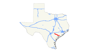
State Highway 111 or SH 111 is a state highway in the U.S. state of Texas that runs from Gonzales to Midfield in Southeast Texas.
Route description
SH 111 begins at an intersection with U.S. Route 183 at the unincorporated community of Hochheim. The official TXDOT route designation has the route dextended northwest with US 183 to Gonzales, but it is not currently measured or mapped as part of the route and is not signed as such. The route travels east to Yoakum, intersecting US 90 Alternate, before travelling into downtown Yoakum. The route then turns southeast the oil field regions toward an intersection with US 59 (Future I-69) at Edna. The route then turns due east, crossing over Lake Texana, before reaching its terminus at SH 71 at Midfield.
History
SH 111 was originally numbered on August 10, 1925 on a route beginning at Hallettsville, and travelling southeast to Edna and continuing to Lolita, before turning east to SH 59 east of Blessing, just south of Midfield, following the rail line of the St. Louis, Brownsville, and Mexico Railway.[2] On April 3, 1931, it was rerouted southward before reaching Blessing, instead going toward the community of Olivia on Matagorda Bay. On January 20, 1932, it was extended south from SH 57 to Olivia.[3] On August 2, 1932, it was rerouted to go through LaWard[4], and SH 172 was designated. On October 26, 1932, the route was conditionally designated over most of that routing, with an extension from Hallettsville west to Gonzales.[5] On September 18, 1933, a section from Hallettsville to Eagle Lake was added, and the section from Hallettsville to Edna was cancelled.[6] On November 22, 1933, the road from Gonazles to Eagle Lake was renumbered as SH 200.[7] On January 9, 1934, the routing was redesignated over its current routing from Midfield to Edna.[8] On September 21, 1937, it extended to Yoakum.[9] On September 26, 1939, SH 111 extended west to Hochheim over a section of SH 95. The route was not completed between Yoakum and Edna until the late 1940s. On October 4, 1968, SH 111 extended north to Gonzales over a section of US 183.
Major intersections
| County | Location | mi | km | Destinations | Notes |
|---|---|---|---|---|---|
| Gonzales | Gonzales | 0.00 | 0.00 | Western end of US 183 concurrency SH 111 is unsigned along this concurrency | |
| DeWitt | Hochheim | Eastern end of US 183 concurrency Western terminus of signed portion of SH 111 | |||
| Yoakum | |||||
| Northern end of Bus. US 77 concurrency | |||||
| Southern end of Bus. US 77 concurrency | |||||
| Lavaca | | ||||
| Jackson | Edna | Diamond interchange with frontage roads; U.S. 59 is the future Interstate 69 | |||
| | |||||
| Matagorda | Midfield | ||||
1.000 mi = 1.609 km; 1.000 km = 0.621 mi
| |||||
References
- ↑ Texas Department of Transportation,
- ↑ (PDF) https://publicdocs.txdot.gov/minord/MinuteOrderDocLib/003676912.pdf. Missing or empty
|title=(help) - ↑ (PDF) https://publicdocs.txdot.gov/minord/MinuteOrderDocLib/003673810.pdf. Missing or empty
|title=(help) - ↑ (PDF) https://publicdocs.txdot.gov/minord/MinuteOrderDocLib/003673820.pdf. Missing or empty
|title=(help) - ↑ (PDF) https://publicdocs.txdot.gov/minord/MinuteOrderDocLib/003673818.pdf. Missing or empty
|title=(help) - ↑ (PDF) https://publicdocs.txdot.gov/minord/MinuteOrderDocLib/003673835.pdf. Missing or empty
|title=(help) - ↑ (PDF) https://publicdocs.txdot.gov/minord/MinuteOrderDocLib/003673840.pdf. Missing or empty
|title=(help) - ↑ (PDF) https://publicdocs.txdot.gov/minord/MinuteOrderDocLib/003673843.pdf. Missing or empty
|title=(help) - ↑ (PDF) https://publicdocs.txdot.gov/minord/MinuteOrderDocLib/003673903.pdf. Missing or empty
|title=(help)