Hinatuan, Surigao del Sur
| Hinatuan | ||
|---|---|---|
| Municipality | ||
| Municipality of Hinatuan | ||
| ||
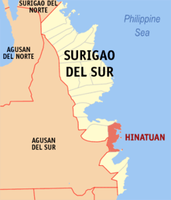 Map of Surigao del Sur with Hinatuan highlighted | ||
.svg.png) Hinatuan Location within the Philippines | ||
| Coordinates: 8°22′N 126°20′E / 8.37°N 126.33°ECoordinates: 8°22′N 126°20′E / 8.37°N 126.33°E | ||
| Country |
| |
| Region | Caraga (Region XIII) | |
| Province | Surigao del Sur | |
| District | 2nd District | |
| Barangays | 24 (see Barangays) | |
| Government [1] | ||
| • Type | Sangguniang Bayan | |
| • Mayor | Shem "Titing" G. Garay | |
| • Vice Mayor | Candelario Viola, Jr. | |
| • Electorate | 25,813 voters (2016) | |
| Area [2] | ||
| • Total | 299.10 km2 (115.48 sq mi) | |
| Population (2015 census)[3] | ||
| • Total | 39,842 | |
| • Density | 130/km2 (350/sq mi) | |
| Time zone | UTC+8 (PST) | |
| ZIP code | 8310 | |
| PSGC | 166809000 | |
| IDD : area code | +63 (0)86 | |
| Climate type | Tropical rainforest climate | |
| Income class | 2nd municipal income class | |
| Revenue (₱) | 143,891,122.13 (2016) | |
| Native languages |
Surigaonon Agusan language Cebuano Tagalog | |
| Website |
hinatuan | |

Hinatuan is a second class municipality in the province of Surigao del Sur, Philippines. According to the 2015 census, it has a population of 39,842 people.[3]
Hinatuan is approximately 44 kilometers (27 miles) north of Bislig, a component city in the same province.
Barangays
Hinatuan is politically subdivided into 24 barangays.
Demographics
| Population census of Hinatuan | |||||||||||||||||||||||||||||||||||||||||||||||||
|---|---|---|---|---|---|---|---|---|---|---|---|---|---|---|---|---|---|---|---|---|---|---|---|---|---|---|---|---|---|---|---|---|---|---|---|---|---|---|---|---|---|---|---|---|---|---|---|---|---|
|
| ||||||||||||||||||||||||||||||||||||||||||||||||
| Source: Philippine Statistics Authority[3][4][5][6] | |||||||||||||||||||||||||||||||||||||||||||||||||
Attractions
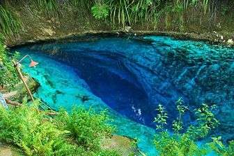
Hinatuan Enchanted River
Clear blue waters of the underground river in Brgy. Talisay, Hinatuan, popularly called as the "Hinatuan Enchanted River" is a known attraction among tourists both locally and internationally.
References
- ↑ "Municipality". Quezon City, Philippines: Department of the Interior and Local Government. Retrieved 31 May 2013.
- ↑ "Province: Surigao del Sur". PSGC Interactive. Quezon City, Philippines: Philippine Statistics Authority. Retrieved 12 November 2016.
- 1 2 3 Census of Population (2015). "Caraga". Total Population by Province, City, Municipality and Barangay. PSA. Retrieved 20 June 2016.
- ↑ Census of Population and Housing (2010). "Caraga". Total Population by Province, City, Municipality and Barangay. NSO. Retrieved 29 June 2016.
- ↑ Censuses of Population (1903–2007). "Caraga". Table 1. Population Enumerated in Various Censuses by Province/Highly Urbanized City: 1903 to 2007. NSO.
- ↑ "Province of Surigao del Sur". Municipality Population Data. Local Water Utilities Administration Research Division. Retrieved 17 December 2016.
External links

- Philippine Standard Geographic Code
- Philippine Census Information
- Local Governance Performance Management System
Places adjacent to Hinatuan, Surigao del Sur | |
|---|---|
Tandag (capital) | |
| Municipalities | |
| Component cities | |
This article is issued from
Wikipedia.
The text is licensed under Creative Commons - Attribution - Sharealike.
Additional terms may apply for the media files.