Magallanes, Agusan del Norte
| Magallanes | ||
|---|---|---|
| Municipality | ||
| Municipality of Magallanes | ||
 .jpg) 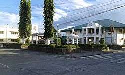 From top, left to right: Aerial view of Magallanes; Nuestra Senora del Rosario Parish; Magallanes Municipal and SB Hall | ||
| ||
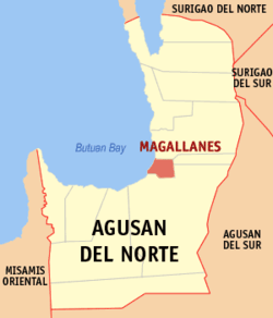 Map of Agusan del Norte with Magallanes highlighted | ||
.svg.png) Magallanes Location within the Philippines | ||
| Coordinates: 9°01′N 125°31′E / 9.02°N 125.52°ECoordinates: 9°01′N 125°31′E / 9.02°N 125.52°E | ||
| Country |
| |
| Region | Caraga (Region XIII) | |
| Province | Agusan del Norte | |
| District | 2nd District | |
| Founded[1] | 21 June 1969 | |
| Barangays | 8 (see Barangays) | |
| Government [2] | ||
| • Type | Sangguniang Bayan | |
| • Mayor | Demosthenes H. Arabaca | |
| • Electorate | 14,457 voters (2016) | |
| Area [3] | ||
| • Total | 44.31 km2 (17.11 sq mi) | |
| Population (2015 census)[4] | ||
| • Total | 21,007 | |
| • Density | 470/km2 (1,200/sq mi) | |
| Time zone | UTC+8 (PST) | |
| ZIP code | 8604 | |
| PSGC | 160208000 | |
| IDD : area code | +63 (0)85 | |
| Climate type | Tropical rainforest climate | |
| Income class | 4th municipal income class | |
| Revenue (₱) | 73,629,222.72 (2016) | |
| Native languages |
Agusan language Butuanon Cebuano Higaonon Tagalog | |
| Website |
www | |
Magallanes, officially the Municipality of Magallanes, (Cebuano: Lungsod sa Magallanes; Tagalog: Bayan ng Magallanes), is a 4th class municipality in the province of Agusan del Norte, Philippines. According to the 2015 census, it has a population of 21,007 people.[4]
The municipality was named after the Portuguese surname of the maritime explorer Ferdinand Magellan. Formerly part of Butuan, Magallanes was created as a municipality on June 21, 1969, through Republic Act 5660.[1]
Geography
Magallanes is located at 9°01′N 125°31′E / 9.02°N 125.52°E.
According to the Philippine Statistics Authority, the municipality has a land area of 44.31 square kilometres (17.11 sq mi) [3] constituting 1.62% of the 2,730.24-square-kilometre- (1,054.15 sq mi) total area of Agusan del Norte.
The topography of the land is mostly flat and rolling, surrounded by mountains. Swamps characterize much of the landscape that is situated at the mouth of the two major rivers in the province, the Agusan and Baug Rivers.
The elevation of most of lands is 2 feet (0.61 m) below sea level. The town center is in the river delta and has to be kept protected by dikes. The land gradually rises in the north-west to the 99-metre- (325 ft) high Mount Taod-oy at barangay Taod-oy and the 162-metre- (531 ft) high Mount Panaytayon.
Around 2,834.89 hectares (7,005.2 acres) of Magallanes lands have slope of 0 to 3 percent, 399.28 hectares (986.6 acres) have 8 to 18 percent, 1,497.30 hectares (3,699.9 acres) 18 to 30 percent and 250.53 hectares (619.1 acres) 30 to 50 percent.
Hydrosol, San Miguel Loam, San Miguel Clay Loam, Malalag Silt Loam and Butuan Loam are its soil types. Upper Miocene, Cretaceous-Paleogene and recent sedimentary materials are the rock elements that make up Magallanes lands.
Land use
Of its total land area, 4,109 hectares (10,150 acres) are classified as alienable and disposable. The other 882 hectares (2,180 acres) are forestlands. 149.95 hectares (370.5 acres) or 3 percent is built-up, 92.26 hectares (228.0 acres) of that for social facilities and the other 59.69 hectares (147.5 acres) for roads. Around 3,210.72 hectares (7,933.9 acres) or 64.33 percent of its lands are utilized for agriculture, the other 1,630.33 hectares (4,028.6 acres) or 33.20 percent, for forest use. Four hectares are also being utilized for tourism in special use. Within the agricultural area, 1,727.63 hectares (4,269.1 acres) are under CARP coverage.
Climate
Magallanes is generally outside the "typhoon belt". Its climate is, by Philippine classification, Type II. There is no definite dry season in the area. Maximum rain is from November to January. Lying within the eastern coast, the place is within the pathway north-east monsoons, trade winds and storms.
Barangays
Magallanes is politically subdivided into eight barangays.[5]
| PSGC | Barangay | Population | ±% p.a. | |||
|---|---|---|---|---|---|---|
| 2015[4] | 2010[6] | |||||
| 160208001 | Buhang | 18.5% | 3,878 | 4,021 | −0.69% | |
| 160208002 | Caloc-an | 20.8% | 4,369 | 4,154 | 0.97% | |
| 160208003 | Guiasan | 7.0% | 1,467 | 1,166 | 4.47% | |
| 160208009 | Marcos | 17.3% | 3,639 | 3,824 | −0.94% | |
| 160208005 | Poblacion | 8.9% | 1,876 | 1,930 | −0.54% | |
| 160208010 | Santo Niño | 7.9% | 1,663 | 1,741 | −0.87% | |
| 160208011 | Santo Rosario | 13.2% | 2,764 | 3,189 | −2.69% | |
| 160208008 | Taod-oy | 6.4% | 1,351 | 1,456 | −1.42% | |
| Total | 21,007 | 21,481 | −0.42% | |||
Demographics
| Population census of Magallanes | ||
|---|---|---|
| Year | Pop. | ±% p.a. |
| 1970 | 7,377 | — |
| 1975 | 11,412 | +9.14% |
| 1980 | 15,994 | +6.98% |
| 1990 | 16,211 | +0.13% |
| 1995 | 17,523 | +1.47% |
| 2000 | 19,895 | +2.76% |
| 2007 | 20,930 | +0.70% |
| 2010 | 21,481 | +0.95% |
| 2015 | 21,007 | −0.42% |
| Source: Philippine Statistics Authority[4][6][7][8] | ||
In the 2015 census, Magallanes had a population of 21,007.[4] The population density was 470 inhabitants per square kilometre (1,200/sq mi).
Economy
The town has two plywood manufacturing firms: EMCO (Brgy. Santo Rosario) and PSPI (Brgy. Marcos), and one safety matches manufacturing firm: JAKA Equities Corp (Brgy. Marcos). The three manufacturing plants are all on the main street and operating near the Baug River and Agusan River.
A 2,000-hectare (4,900-acre) of prawn/shrimp farm in Magallanes used to be the Philippines' top exporter of first class prawn/shrimp to Japan, until the entire farm was hit by a white spot disease in 2001 leading to the collapse of the industry.
Attractions
.jpg)
- Philippine Centennial Tree
- The Department of Environment and Natural Resources (DENR) awarded Magallanes as the place that host the Oldest Tree (more than 500 years old) in the Philippines called Bitaug.
- Lisagan Festival
- Magallanes celebrates its annual fiesta every third Saturday of October in honor of patroness Nuestra Señora del Rosario, Our Lady of the Rosary, which includes thanksgiving mass, parades and more.
- The 'Lisagan Festival' held on Sunday after the fiesta includes street dancing similar to Sinulog Festival and fluvial procession at the Agusan River and Baug River. The town parish doesn't allow major public gathering like disco, live bands and other similar events the night before the fiesta.
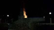
- Magellan Shrine
- Located at Poblacion near the Municipal Hall, the shrine was the site of the 'first' Catholic mass in Mindanao on April 8, 1521. It was believed that the Magellan's Cross in Cebu was also erected here by the explorer Ferdinand Magellan and his men before they sail North. Evidence showed church ruins near the Agusan River.
- Agusan River
- The Agusan River is the widest and navigable river in Mindanao.
Transportation
Magallanes can be reached through the Mindanao gateways:
Air
- Bancasi Airport of Butuan and Laguindingan International Airport of Cagayan de Oro and Iligan
- PAL Express and Cebu Pacific have daily flights from Manila to Butuan and v.v. Cebu-Butuan-Cebu flights via Cebu Pacific scheduled Mondays, Wednesdays and Saturdays, and PAL.
.jpg)
Sea
- Port of Nasipit
- Port of Surigao
- Macabalan Port of Cagayan de Oro
There are several major shipping lines serving the Manila and Cebu routes namely: 2Go, Cokaliong, and PSACC.
The boat ride from Butuan to Magallanes, navigating the Agusan River, takes about 45 minutes.
Land
Bachelor Express and PhilTranCo is the dominant public land transport from Manila and Tacloban passing Surigao, Cabadbaran and Butuan to Cagayan de Oro and Davao. The public mode of transportation within the municipality is by motorcabs and pedicabs. Passenger vans commonly known as V-Hire are also available for Butuan routes.
References
- 1 2 "Republic Act No. 5660; An Act Creating the Municipality of Magallanes, Province of Agusan". The Corpus Juris. 21 June 1969. Archived from the original on 16 October 2016. Retrieved 16 October 2016.
- ↑ "Municipality". Quezon City, Philippines: Department of the Interior and Local Government. Retrieved 31 May 2013.
- 1 2 "Province: Agusan del Norte". PSGC Interactive. Quezon City, Philippines: Philippine Statistics Authority. Retrieved 12 November 2016.
- 1 2 3 4 5 Census of Population (2015). "Caraga". Total Population by Province, City, Municipality and Barangay. PSA. Retrieved 20 June 2016.
- ↑ "Municipal: Magallanes, Agusan del Norte". PSGC Interactive. Quezon City, Philippines: Philippine Statistics Authority. Retrieved 8 January 2016.
- 1 2 Census of Population and Housing (2010). "Caraga". Total Population by Province, City, Municipality and Barangay. NSO. Retrieved 29 June 2016.
- ↑ Censuses of Population (1903–2007). "Caraga". Table 1. Population Enumerated in Various Censuses by Province/Highly Urbanized City: 1903 to 2007. NSO.
- ↑ "Province of Agusan del Norte". Municipality Population Data. Local Water Utilities Administration Research Division. Retrieved 17 December 2016.
- ↑ "Malaking Sanga ng Pambansang Sentenaryong Puno ng Pilipinas, Nabali!". rmn. Retrieved 4 Jul 2017.
External links
| Wikimedia Commons has media related to Magallanes, Agusan del Norte. |
Places adjacent to Magallanes, Agusan del Norte | ||||||||||
|---|---|---|---|---|---|---|---|---|---|---|
| ||||||||||
Cabadbaran (capital) | |
| Municipalities | |
| Component city | |
| Highly urbanized city |
|